Hilaire Belloc - The Collected Works of Hilaire Belloc
Здесь есть возможность читать онлайн «Hilaire Belloc - The Collected Works of Hilaire Belloc» — ознакомительный отрывок электронной книги совершенно бесплатно, а после прочтения отрывка купить полную версию. В некоторых случаях можно слушать аудио, скачать через торрент в формате fb2 и присутствует краткое содержание. Жанр: unrecognised, на английском языке. Описание произведения, (предисловие) а так же отзывы посетителей доступны на портале библиотеки ЛибКат.
- Название:The Collected Works of Hilaire Belloc
- Автор:
- Жанр:
- Год:неизвестен
- ISBN:нет данных
- Рейтинг книги:5 / 5. Голосов: 1
-
Избранное:Добавить в избранное
- Отзывы:
-
Ваша оценка:
The Collected Works of Hilaire Belloc: краткое содержание, описание и аннотация
Предлагаем к чтению аннотацию, описание, краткое содержание или предисловие (зависит от того, что написал сам автор книги «The Collected Works of Hilaire Belloc»). Если вы не нашли необходимую информацию о книге — напишите в комментариях, мы постараемся отыскать её.
Nonfiction:
History
The Book of the Bayeux Tapestry
The Path to Rome
The Old Road
The French Revolution
Blenheim
Tourcoing
Crécy
Waterloo
Malplaquet
Poitiers
First and Last
Europe and the Faith
Survivals and New Arrivals: The Old and New Enemies of the Catholic Church
The Jews
The Historic Thames
A Change in the Cabinet
A General Sketch of the European War: The First Phase
The Two Maps of Europe
Economics
Servile State
Essays:
Avril: Essays on the Poetry of the French Renaissance
Hills and the Sea
On Nothing and Kindred Subjects
On Everything
On Anything
On Something
This and That
On
The Free Press
Fiction:
Novels & Short Stories
The Mercy of Allah
The Green Overcoat
Poetry:
A Moral Alphabet
Bad Child's Book of Beasts
More Beasts For Worse Children
The Modern Traveller
Cautionary Tales for Children
More Peers
The Collected Works of Hilaire Belloc — читать онлайн ознакомительный отрывок
Ниже представлен текст книги, разбитый по страницам. Система сохранения места последней прочитанной страницы, позволяет с удобством читать онлайн бесплатно книгу «The Collected Works of Hilaire Belloc», без необходимости каждый раз заново искать на чём Вы остановились. Поставьте закладку, и сможете в любой момент перейти на страницу, на которой закончили чтение.
Интервал:
Закладка:
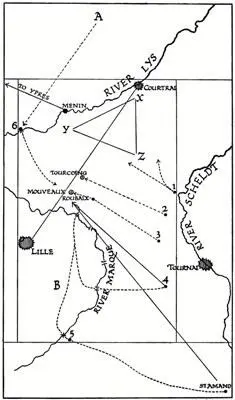
The object of the whole convergence from the Scheldt on one hand, and from Clerfayt’s northern position upon the other, being to cut off the French forces which lay at and south of Courtrai from Lille, and the main line of the French army, it is evident that the actual fighting and the chances of success or disaster would take place within a smaller interior oblong, which I have also marked upon the sketch map. This smaller or interior oblong measures about sixteen miles at its base by about twenty-five miles in length, and includes all the significant points of the action.
The points marked 1, 2, 3, 4, and 5 respectively are the points at which the five columns advancing from the Scheldt valley northward were to find themselves before dawn on the morning of Saturday the 17th of May. We are already acquainted with them. They are Warcoing, Bailleul, Templeuve, Froidmont, and Pont-à-Marcq respectively; while the point marked 6 is Wervicq, from which Clerfayt was to start simultaneously with the five southern columns with the object of meeting his fellows round Tourcoing.
The town of Courtrai will be perceived to lie in the north-eastern angle of this inner oblong, the town of Lille rather below the middle of its western side. In all the country round Courtrai, and especially to the south of it, within the triangle X Y Z, lay the mass of Souham’s command of 40,000 men. There were many posts, of course, scattered outside that triangle, and connecting Courtrai with Lille; but the links were weak, and the main force was where I have indicated it to be.
A large body of French troops being encamped just under the walls of Lille at B (by which letter I mark Sainghin camp), and that fortress also possessing a garrison, the plan of cutting both these off from the 40,000 French that lay in the country near Courtrai involved getting the main part of the allies up from these points of departure on the south, and Clerfayt’s body down from its point of departure on the north to meet upon the line drawn between Lille and Courtrai. Upon this line (which also roughly corresponds to the only main road between the two cities) may be perceived, lying nearer Lille than the centre of such line, the small town of Tourcoing and the village of Mouveaux. It was upon these two points that four of the five southern columns were to converge northward, the second and third column reaching them first, the fourth and fifth marching up from the left in aid; and it was also, of course, upon these two points that Clerfayt was to march southward from the post at Wervicq, that had been given him as his point of departure before dawn upon that Saturday morning. If everything went perfectly, the great mass of the allied army should have found itself, by noon of Saturday the 17th, as I have said, astraddle of the Lille-Courtrai road, and effectively cutting off the French troops to the north.
What was the nature of the wide countryside over which these various movements were to take place?
It was part of that great plain of Flanders which stretches from the River Scheldt almost unbroken to the Straits of Dover and the North Sea. In the whole of the great oblong represented by my sketch map there is hardly a point 150 feet above the water level of the main river valleys, while the great mass of that territory is diversified by no more than very broad and very shallow rolls of land, the crests of which are sometimes and exceptionally as much as fifty feet above the troughs, but the greater part thirty, twenty, or even less. Here and there an isolated hummock shows upon the landscape, but the general impression of one who walks across from the valley of the Lys to that of the Scheldt is of a flat, monotonous land in which one retains no memory of ascent or descent, and in which the eye but rarely perceives, and that only from specially chosen points, any wide horizon.
To-day the greater part of this country suffers from the curse of industrialism and repeats—of course, with far less degradation—the terrible aspect of our own manufacturing towns. Roubaix and Tourcoing in particular are huge straggling agglomerations of cotton-spinners and their hands. A mass of railways and tramways cut the countryside, and the evil presence of coal-smoke mars it everywhere: at least within the region of Lille, Tourcoing, and Roubaix.
In May 1794, though a considerable industry had begun to grow up in Lille itself, the wide, open countryside round the town was entirely agricultural. Much of it was what soldiers call “blind” country: that is, it was cut up into fields with numerous hedges; there were long farm walls and a great number of small watercourses fringed with trees. But, on the other hand, there was very little wood. Moreover, though there were few places from which one could overlook any considerable view, the “blindness” of the field, as a whole, has been much exaggerated in the attempt to excuse or explain the disaster of which it was the theatre. The southern part of it is open enough, and so is the north-eastern portion, in which the first column operated. Of the soil no particular mention is needed; most of the great roads were paved; the weather had created no difficulty in the going, and the only trouble in this respect lay in the northern part, where Clerfayt’s command was condemned to advance over patches of loose and difficult sand, which made the road, or rather rare lanes, very heavy.
It will at once be perceived that, in view of the operations planned, one principal obstacle exists in the terrain, the River Lys. Few bridges crossed this stream, and for the purpose of turning the French position and coming across the Lys from the north to the neighbourhood of Mouveaux, there was in those days no bridge save the bridge at Wervicq (at the point marked 6 on the plan at the beginning of this section); but this difficulty we have seen to be lessened by the presence in Clerfayt’s command of a section of pontoons.
At first sight one might perceive no other considerable obstacle save the Lys to the general movement of the allied army. But when the peculiar course of the little River Marque is pointed out, and the nature of its stream described, the reader will perceive that it exercised some little effect upon the fortunes of the battle, and might have exercised a much greater one to the advantage of the British troops had not the Duke of York blundered in a fashion which will be later described.
In the first place, it should be noted that this little stream (it is no wider than a canal, will barely allow two barges to pass in its lower course, and will not float one to the southward of Lille) turns up quite close to Roubaix, and at the nearest point is not a mile from the market-place of that town.
Now the significance of such a conformation to the battlefield of Tourcoing lay in the fact that it was impossible for any considerable force to manœuvre between the third column (which was marching upon Roubaix) and the Marque River. Had the Marque not existed, Kinsky, with the fourth column, would have been free to march parallel with York, just as York marched parallel with Otto, while the Arch-Duke with his fifth column, instead of having been given a rendezvous right down south at Pont-à-Marcq (the point marked 5 on my sketch), would have gone up the main road from St. Amand to Lille, and have marched parallel with Kinsky, just as Kinsky would have marched parallel with York. In other words, the fourth and the fifth columns, instead of being ordered along the dotted lines marked upon my sketch (the elbows in which lines correspond to the crossing places of the Marque), would have proceeded along the uninterrupted arrow lines which I have put by the side of them.
Читать дальшеИнтервал:
Закладка:
Похожие книги на «The Collected Works of Hilaire Belloc»
Представляем Вашему вниманию похожие книги на «The Collected Works of Hilaire Belloc» списком для выбора. Мы отобрали схожую по названию и смыслу литературу в надежде предоставить читателям больше вариантов отыскать новые, интересные, ещё непрочитанные произведения.


Обсуждение, отзывы о книге «The Collected Works of Hilaire Belloc» и просто собственные мнения читателей. Оставьте ваши комментарии, напишите, что Вы думаете о произведении, его смысле или главных героях. Укажите что конкретно понравилось, а что нет, и почему Вы так считаете.