Michael Graham - Wind Energy Handbook
Здесь есть возможность читать онлайн «Michael Graham - Wind Energy Handbook» — ознакомительный отрывок электронной книги совершенно бесплатно, а после прочтения отрывка купить полную версию. В некоторых случаях можно слушать аудио, скачать через торрент в формате fb2 и присутствует краткое содержание. Жанр: unrecognised, на английском языке. Описание произведения, (предисловие) а так же отзывы посетителей доступны на портале библиотеки ЛибКат.

- Название:Wind Energy Handbook
- Автор:
- Жанр:
- Год:неизвестен
- ISBN:нет данных
- Рейтинг книги:3 / 5. Голосов: 1
-
Избранное:Добавить в избранное
- Отзывы:
-
Ваша оценка:
Wind Energy Handbook: краткое содержание, описание и аннотация
Предлагаем к чтению аннотацию, описание, краткое содержание или предисловие (зависит от того, что написал сам автор книги «Wind Energy Handbook»). Если вы не нашли необходимую информацию о книге — напишите в комментариях, мы постараемся отыскать её.
delivers a fully updated treatment of key developments in wind technology since the publication of the book’s Second Edition in 2011. The criticality of wakes within wind farms is addressed by the addition of an entirely new chapter on wake effects, including ‘engineering’ wake models and wake control. Offshore, attention is focused for the first time on the design of floating support structures, and the new ‘PISA’ method for monopile geotechnical design is introduced.
The coverage of blade design has been completely rewritten, with an expanded description of laminate fatigue properties and new sections on manufacturing methods, blade testing, leading-edge erosion and bend-twist coupling. These are complemented by new sections on blade add-ons and noise in the aerodynamics chapters, which now also include a description of the Leishman-Beddoes dynamic stall model and an extended introduction to Computational Fluid Dynamics analysis.
The importance of the environmental impact of wind farms both on- and offshore is recognised by extended coverage, which encompasses the requirements of the Grid Codes to ensure wind energy plays its full role in the power system. The conceptual design chapter has been extended to include a number of novel concepts, including low induction rotors, multiple rotor structures, superconducting generators and magnetic gearboxes.
References and further reading resources are included throughout the book and have been updated to cover the latest literature. Importantly, the core subjects constituting the essential background to wind turbine and wind farm design are covered, as in previous editions. These include:
The nature of the wind resource, including geographical variation, synoptic and diurnal variations and turbulence characteristics The aerodynamics of horizontal axis wind turbines, including the actuator disc concept, rotor disc theory, the vortex cylinder model of the actuator disc and the Blade-Element/Momentum theory Design loads for horizontal axis wind turbines, including the prescriptions of international standards Alternative machine architectures The design of key components Wind turbine controller design for fixed and variable speed machines The integration of wind farms into the electrical power system Wind farm design, siting constraints and the assessment of environmental impact Perfect for engineers and scientists learning about wind turbine technology, the
will also earn a place in the libraries of graduate students taking courses on wind turbines and wind energy, as well as industry professionals whose work requires a deep understanding of wind energy technology.
Wind Energy Handbook — читать онлайн ознакомительный отрывок
Ниже представлен текст книги, разбитый по страницам. Система сохранения места последней прочитанной страницы, позволяет с удобством читать онлайн бесплатно книгу «Wind Energy Handbook», без необходимости каждый раз заново искать на чём Вы остановились. Поставьте закладку, и сможете в любой момент перейти на страницу, на которой закончили чтение.
Интервал:
Закладка:
From the point of view of wind energy, the most striking characteristic of the wind resource is its variability. The wind is highly variable, both geographically and temporally. Furthermore, this variability persists over a very wide range of scales, both in space and time. The importance of this is amplified by the cubic relationship to available energy.
On a large scale, spatial variability describes the fact that there are many different climatic regions in the world, some much windier than others. These regions are largely dictated by the latitude, which affects the amount of insolation. Within any one climatic region, there is a great deal of variation on a smaller scale, largely dictated by physical geography – the proportion of land and sea, the size of land masses, and the presence of mountains or plains, for example. The type of vegetation may also have a significant influence through its effects on the absorption or reflection of solar radiation, affecting surface temperatures, and on humidity.
More locally, the topography has a major effect on the wind climate. More wind is experienced on the tops of hills and mountains than in the lee of high ground or in sheltered valleys, for instance. More locally still, wind velocities are significantly reduced by obstacles such as trees or buildings.
At a given location, temporal variability on a large scale means that the amount of wind may vary from one year to the next, with even longer‐scale variations on a scale of decades or more. These long‐term variations are not well understood and may make it difficult to make accurate predictions of the economic viability of particular wind farm projects, for instance.
On timescales shorter than a year, seasonal variations are much more predictable, although there are large variations on shorter timescales still, which although reasonably well understood are often not very predictable more than a few days ahead. Depending on location, there may also be considerable variations with the time of day (diurnal variations), which again are usually fairly predictable. On these timescales, the predictability of the wind is important for integrating large amounts of wind power into the electricity network, to allow the other generating plant supplying the network to be organised appropriately.
On still shorter timescales of minutes down to seconds or less, wind speed variations known as turbulence can have a very significant impact on the design and performance of the individual wind turbines as well as on the quality of power delivered to the network and its effect on consumers.
Van der Hoven (1957) constructed a wind speed spectrum from long‐ and short‐term records at Brookhaven, New York, showing clear peaks corresponding to the synoptic, diurnal, and turbulent effects just referred to ( Figure 2.1). This spectrum shows a distinct ‘spectral gap’ between the diurnal and turbulent peaks, showing that the synoptic and diurnal variations can be treated as quite distinct from the higher frequency fluctuations of turbulence, with very little energy in the spectrum in the region between 2 hours and 10 minutes. As indicated in the next section, however, the nature of the wind regime in different geographical locations can vary widely, so the Van der Hoven spectrum cannot be assumed to be universally applicable, and the spectral gap may not always be so distinct. Nevertheless, the concept of a spectral gap at frequencies below 10 minutes is very often used, often implicitly, when making assumptions about the wind regime; for example, when defining turbulence intensity.
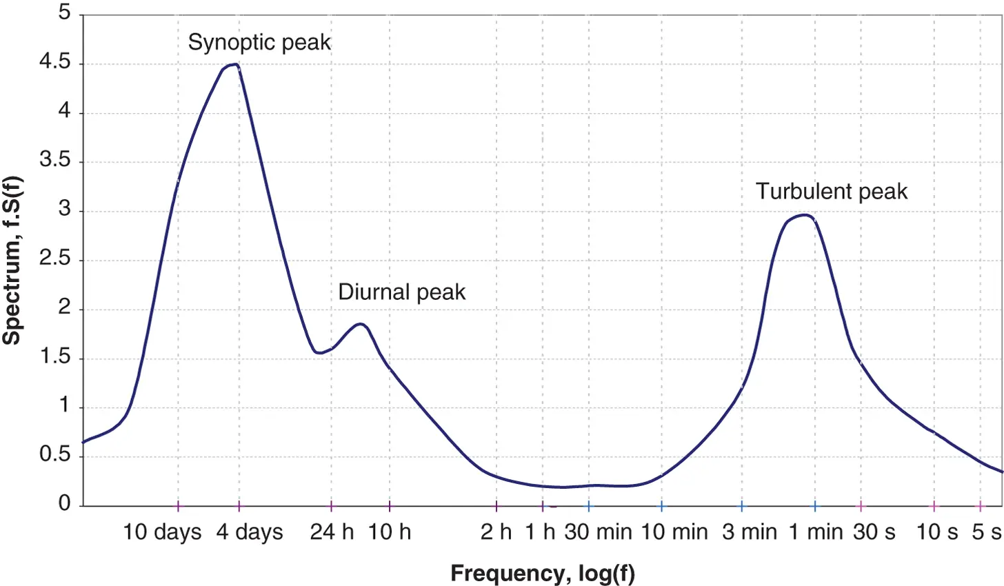
Figure 2.1 Wind spectrum from Brookhaven based on work by Van der Hoven (1957)
2.2 Geographical variation in the wind resource
Ultimately the winds are driven almost entirely by the sun's energy, causing differential surface heating. The heating is most intense on land masses closer to the equator, and obviously the greatest heating occurs in the daytime, which means that the region of greatest heating moves around the earth's surface as it spins on its axis. Warm air rises and circulates in the atmosphere to sink back to the surface in cooler areas. The resulting large‐scale motion of the air is strongly influenced by Coriolis forces due to the earth's rotation. The result is a large‐scale global circulation pattern. Certain identifiable features of this such as the trade winds and the ‘roaring forties’ are well known.
The non‐uniformity of the earth's surface, with its pattern of land masses and oceans, ensures that this global circulation pattern is disturbed by smaller‐scale variations on continental scales. These variations interact in a highly complex and non‐linear fashion to produce a somewhat chaotic result, which is at the root of the day‐to‐day unpredictability of the weather in particular locations. Clearly though, underlying tendencies remain that lead to clear climatic differences between regions. These differences are tempered by more local topographical and thermal effects.
Hills and mountains result in local regions of increased wind speed. This is partly a result of altitude – the boundary layer flow over the earth's surface means that wind speed generally increases with height above the ground, and hill tops and mountain peaks may ‘project’ into the higher wind speed layers. It is also partly a result of the acceleration of the wind flow over and around hills and mountains and funnelling through passes or along valleys aligned with the flow. Equally, topography may produce areas of reduced wind speed, such as sheltered valleys or areas in the lee of a mountain ridge or where the flow patterns result in stagnation points.
Thermal effects may also result in considerable local variations. Coastal regions are often windy because of differential heating between land and sea. While the sea is warmer than the land, a local circulation develops in which surface air flows from the land to the sea, with warm air rising over the sea and cool air sinking over the land. When the land is warmer, the pattern reverses. The land will heat up and cool down more rapidly than the sea surface, and so this pattern of land and sea breezes tends to reverse over a 24‐hour cycle. These effects were important in the early development of wind power in California, where an ocean current brings cold water to the coast, not far from desert areas that heat up strongly by day. An intervening mountain range funnels the resulting air flow through its passes, generating locally very strong and reliable winds (which are well correlated with peaks in the local electricity demand caused by air conditioning loads).
Thermal effects may also be caused by differences in altitude. Thus, cold air from high mountains can sink down to the plains below, causing quite strong and highly stratified ‘downslope’ winds.
The brief general descriptions of wind speed variations in Sections 2.1– 2.5are illustrative, and more detailed information can be found in standard meteorological texts. Section 10.1.3, in Chapter 10, describes how the wind regimes at candidate sites can be assessed, while wind forecasting is covered in Section 2.9and Section 11.6.3.
Section 2.6presents a more detailed description of the high frequency wind fluctuations known as turbulence , which are crucial to the design and operation of wind turbines and have a major influence on wind turbine loads. Extreme winds are also important for the survival of wind turbines, and these are described in Section 2.8.
2.3 Long‐term wind speed variations
There is evidence that the wind speed at any particular location may be subject to very slow long‐term variations. Although the availability of accurate historical records is a limitation, careful analysis by, for example, Palutikof et al. (1991) has demonstrated clear trends. Clearly these may be linked to long‐term temperature variations for which there is ample historical evidence. There is also much debate at present about the likely effects of global warming, caused by human activity, on climate, and this will undoubtedly affect wind climates in the coming decades.
Читать дальшеИнтервал:
Закладка:
Похожие книги на «Wind Energy Handbook»
Представляем Вашему вниманию похожие книги на «Wind Energy Handbook» списком для выбора. Мы отобрали схожую по названию и смыслу литературу в надежде предоставить читателям больше вариантов отыскать новые, интересные, ещё непрочитанные произведения.


Обсуждение, отзывы о книге «Wind Energy Handbook» и просто собственные мнения читателей. Оставьте ваши комментарии, напишите, что Вы думаете о произведении, его смысле или главных героях. Укажите что конкретно понравилось, а что нет, и почему Вы так считаете.