Iceland Within the Northern Atlantic, Volume 1
Здесь есть возможность читать онлайн «Iceland Within the Northern Atlantic, Volume 1» — ознакомительный отрывок электронной книги совершенно бесплатно, а после прочтения отрывка купить полную версию. В некоторых случаях можно слушать аудио, скачать через торрент в формате fb2 и присутствует краткое содержание. Жанр: unrecognised, на английском языке. Описание произведения, (предисловие) а так же отзывы посетителей доступны на портале библиотеки ЛибКат.
- Название:Iceland Within the Northern Atlantic, Volume 1
- Автор:
- Жанр:
- Год:неизвестен
- ISBN:нет данных
- Рейтинг книги:5 / 5. Голосов: 1
-
Избранное:Добавить в избранное
- Отзывы:
-
Ваша оценка:
Iceland Within the Northern Atlantic, Volume 1: краткое содержание, описание и аннотация
Предлагаем к чтению аннотацию, описание, краткое содержание или предисловие (зависит от того, что написал сам автор книги «Iceland Within the Northern Atlantic, Volume 1»). Если вы не нашли необходимую информацию о книге — напишите в комментариях, мы постараемся отыскать её.
Iceland Within the Northern Atlantic, Volume 1 — читать онлайн ознакомительный отрывок
Ниже представлен текст книги, разбитый по страницам. Система сохранения места последней прочитанной страницы, позволяет с удобством читать онлайн бесплатно книгу «Iceland Within the Northern Atlantic, Volume 1», без необходимости каждый раз заново искать на чём Вы остановились. Поставьте закладку, и сможете в любой момент перейти на страницу, на которой закончили чтение.
Интервал:
Закладка:
The GIFR crust has an anomalous thickness, ranging from 25 to 40 km, equivalent to that of a continental crust. It is not associated with any interpretable magnetic anomalies except locally between Iceland and the Faroes (Nuuns et al. 1983; Hjartarson et al. 2017).
1.3. Geodynamic characteristics of Iceland
One of the characteristics of Iceland is its sustained volcanic activity, accompanied by hydrothermal activity and almost permanent seismicity, although most of the time it is of low intensity and localized. Another major feature of the island lies in the presence of large glaciers and all that it implies from a geodynamic, climatic, touristic and industrial point of view.
1.3.1. Seismicity
While seismic activity in Iceland underlines all plate boundaries ( Figure 1.7), it is less continuous and less strong in the rift and is mainly concentrated in the transform zones that connect the active rift to the offshore segments of the ridge to the north and south of the island.
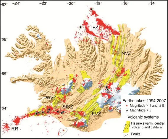
Figure 1.7. Seismicity in Iceland recorded by the SIL network between 1994 and 2007 (modified from Jakobsdóttir 2008). Volcanic systems according to Einarsson and Sæmundsson (1987). EVZ: East Volcanic Zone; NVZ: North Volcanic Zone; WVZ: West Volcanic Zone; ZFT: Tjörnes Fracture Zone; SISZ: South Iceland Seismic Zone
The Icelandic Rift corresponds to the onshore extensions of two segments of the North-MAR, the Reykjanes Ridge to the south and the Kolbeinsey Ridge to the north ( Figures 1.2and 1.5). It has three branches ( Figure 1.7), all offset eastward from the axis of the North-MAR. These branches of the rift consist of fissure swarms associated with active central volcanoes, a significant portion of which are located beneath the major glaciers of the island; they can be guessed from the ice-free topographic map ( Figure 1.2(b)). In the rift, seismicity is strongly linked to the functioning of magmatic systems ( Figure 1.7). This seismicity of volcanic origin and the volcanism itself (for example, the recent eruption of the Bárðarbunga volcano and its large flow of basaltic lava) testify to an important active magmatism supposed to be fed by the Icelandic hot spot.
The shift of the Icelandic rift with respect to the axis of the North-MAR is accommodated by two transform zones, the South Iceland Seismic Zone (SISZ) to the south and the Tjörnes Fracture Zone (TFZ) to the north. Both are inherited from an older history, that of the opening of the Atlantic ( Chapter 3) and linked to the “rift jump” phenomenon ( Chapter 2). It is in these two transform zones that seismicity is the most sustained ( Figure 1.7) with both quasi-permanent microseismicity and major recurrent seismicity whose magnitude can exceed 7 ( section 2.2.1).
The disposition of the two rift branches in the south of the island (WVZ and EVZ) resembles that of the overlapping spreading centers (OSC) described on fast-spreading ridges, rather than that of a true transform zone. Nevertheless, the associated seismicity characterizes well the left-lateral transform motion of the SISZ, connecting the EVZ to the Reykjanes Ridge. At present, the two branches of the rift do not have the same level of activity, and the WVZ accommodates only a small part of the extension; the question of whether this present low activity is representative of the last thousands or millions of years will be discussed in Chapter 2.
1.3.2. Icelandic volcanism
Since its insularization, 16 My ago, Iceland has formed a volcanic land located in a central position in the Atlantic Ocean, a site subject to numerous effusive fissural eruptions. Therefore, it is also one of the main areas of the northern hemisphere generating explosive eruptions emitting into the atmosphere ashes, tephra and gases.
Icelandic quaternary volcanism allows us to understand, by its outcrop along coastal cliffs or canyons, the mechanisms of formation of numerous eruptive figures in aerial or underwater basaltic environments. This is the case of rootless volcanoes and lava lakes ( section 1.2of Volume 2), the establishment of dykes or sills and their control by tectonics, or the evolution of stresses related to glaciations. We have shown that close mechanical and physical links probably exist between deglaciation, volcanism, seismicity and tectonic deformations ( section 2.1of Volume 2). The key process lies in variations in the adiabatic melting rate of the mantle near the lithosphere/asthenosphere boundary, induced by decompression related to crustal extension or glacio-isostatic discharge. The emission zones of these lava flows have therefore constrained the evolution of Iceland since the onset of glaciations. It also enabled the understanding of the formation of SDRs (Seaward Deeping Reflectors), a mode of accumulation of lava flows especially recognized by seismic reflection along the margins of the North Atlantic.
Tephra successions are commonly recorded in the cores drilled in the Greenland ice cap and in marine sediments deposited on the bottom of the North Atlantic. Some of these tephras were distally dated by radiocarbon as in the peat bogs of northern Europe, others by age patterns in ice or marine sedimentary accumulations ( sections 1.3and 3.2of Volume 2). More rarely, their dating has been performed directly by K-Ar analysis ( section 2.4of Volume 2). These emissions of tephra and associated gases have a significant environmental impact on ocean fertility, as the GIFR seabed is an important breeding ground for the majority of fish consumed, as well as on the health of human or animal populations and on air safety, as shown by the recent eruption of Eyjafjallajökull (2010).
1.3.3. Eustatism and the Icelandic glaciers
The full insularization of Iceland began about 16 My ago ( Figures 1.2and 1.8). The evolution of Iceland until around 9 My was mainly controlled by the tectonic and magmatic processes related to both the opening of the Atlantic Ocean and the evolution of the hot spot. They built a classically evolving volcanic island, even if its formation was unusual ( Chapter 3). The last rift jump ( Chapter 2) in the north of the island started about 8 My ago. Then a rift jump occurred in the south of the island around 3 My, when the great glaciations started. At the same time, Iceland’s shape was also influenced by global eustatic evolution, which allowed the development of marine abrasion surfaces around the island ( Figures 1.8and 1.9).
The development of radiometric dating ( section 2.4of Volume 2) allowed us to better constrain both the chronology of the progressive extinction of the paleorifts and also that of the glaciations with respect to the tectonic and paleo-oceanographic evolution of the North Atlantic. The impact of the glacial loading of rifts during periods of extended ice caps could explain pro parte this cyclic evolution linked to rift-jump.
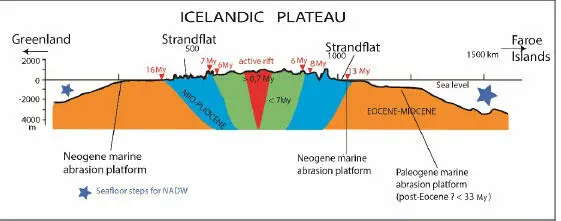
Figure 1.8. W-E topographic section of Iceland with its various morphological and geological dated constituents. The geology is partially hypothetical, adapted and completed from (Hjartason et al. 2007). K-Ar dates are in red. NADW: North Atlantic Deep Water
The upper plateau of the island, raised at about 600 m in altitude, is a relatively recent construction (<7 My) as far as the age of dyke injection and subaerialvolcanism is concerned. The peninsulas of Flateyjarskagi, Tröllaskagi and Tjörnes are mainly constituted by lava flows dated between 5 and 3 My, interspersed with glacial and marine formations, as in the sector of Husavik. The peninsulas of the northwest and east consist of much older lavas. The ages of these basaltic series usually range between 7 and 6 My very locally reaching 16 My at their base (in the west).
Читать дальшеИнтервал:
Закладка:
Похожие книги на «Iceland Within the Northern Atlantic, Volume 1»
Представляем Вашему вниманию похожие книги на «Iceland Within the Northern Atlantic, Volume 1» списком для выбора. Мы отобрали схожую по названию и смыслу литературу в надежде предоставить читателям больше вариантов отыскать новые, интересные, ещё непрочитанные произведения.


Обсуждение, отзывы о книге «Iceland Within the Northern Atlantic, Volume 1» и просто собственные мнения читателей. Оставьте ваши комментарии, напишите, что Вы думаете о произведении, его смысле или главных героях. Укажите что конкретно понравилось, а что нет, и почему Вы так считаете.