Iceland Within the Northern Atlantic, Volume 1
Здесь есть возможность читать онлайн «Iceland Within the Northern Atlantic, Volume 1» — ознакомительный отрывок электронной книги совершенно бесплатно, а после прочтения отрывка купить полную версию. В некоторых случаях можно слушать аудио, скачать через торрент в формате fb2 и присутствует краткое содержание. Жанр: unrecognised, на английском языке. Описание произведения, (предисловие) а так же отзывы посетителей доступны на портале библиотеки ЛибКат.
- Название:Iceland Within the Northern Atlantic, Volume 1
- Автор:
- Жанр:
- Год:неизвестен
- ISBN:нет данных
- Рейтинг книги:5 / 5. Голосов: 1
-
Избранное:Добавить в избранное
- Отзывы:
-
Ваша оценка:
Iceland Within the Northern Atlantic, Volume 1: краткое содержание, описание и аннотация
Предлагаем к чтению аннотацию, описание, краткое содержание или предисловие (зависит от того, что написал сам автор книги «Iceland Within the Northern Atlantic, Volume 1»). Если вы не нашли необходимую информацию о книге — напишите в комментариях, мы постараемся отыскать её.
Iceland Within the Northern Atlantic, Volume 1 — читать онлайн ознакомительный отрывок
Ниже представлен текст книги, разбитый по страницам. Система сохранения места последней прочитанной страницы, позволяет с удобством читать онлайн бесплатно книгу «Iceland Within the Northern Atlantic, Volume 1», без необходимости каждый раз заново искать на чём Вы остановились. Поставьте закладку, и сможете в любой момент перейти на страницу, на которой закончили чтение.
Интервал:
Закладка:
Strandflat is a marine abrasion surface that can be found along the whole North Atlantic. It has sometimes been attributed to the action of glaciers only, but is scoured both on the edge of continents and in Iceland by large glacial valleys that reuse a pre-existing hydrographic network. Between +20 and −50 m, the platform of the Icelandic strandflat contains mostly lava flows dated between 7 and 10 My. It is strongly shaped by the action of glaciers. Several ages, obtained from interglacial flows fossilizing the strandflat, are distributed between 1.8 My on Skagi to 0.13 My for Snæfellnes: it is therefore polygenetic. It is also continuous over several dozen square kilometers between the three great peninsulas of the west coast. In the rest of the island, it forms a relatively narrow terrace.

Figure 1.9. Global sea level evolution from the Eocene to the present day in relation to glaciations and the development of thermohaline circulation
COMMENT ON FIGURE 1.9.– ( 1) Compilation of sea level changes (based on (Abreu et al. 1998)). (2) Curve δ18O compiled by Cramer et al. (2008). (3) Eustatic curves defined by Miller et al. (2005, 2011, in black and blue) and Kominz et al. (2008, in brown). The blue background reflects the intensification of the thermohaline circulation. SH: Southern hemisphere, NH: Northern hemisphere. It can be compared with Figures 3.6. and 3.3(B) in Volume 2.
The submerged platform that lies between −200 m and −50 m around the island ( Figures 1.1and 1.3) truncates the Miocene and Oligocene effusive formations of the GIR (Hjartason et al. 2007; Chapter 3of this volume). This platform is itself scoured by glaciers ( Figures 1.3and 1.10) as is the West Coast of Spitsbergen or the coast of Newfoundland (Figure 3.1(A)), which are free of volcanic activity.
The evolution of the eustatic signature (Miller et al. 2005, 2011; Kominz et al. 2008) on long time scales indicates that the tectono-eustatic component has not exceeded 50 m since 60 My (Rowley 2013), mainly as a result of variations in seafloor production and mantle evolution.
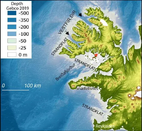
Figure 1.10. The Northwest Peninsula, western Iceland, and the strandflat
COMMENT ON FIGURE 1.10.– Subsident morphology with a very large strandflat (<50 m, clear) south of the Northwest Peninsula and west of Iceland with fossilized coastal cliffs, flooded glacial valleys up to the upstream cirque (red arrow) and eroded platform in the Vestfirðir sector. Neogene and Quaternary glacial overdeepenings are indicated by black arrows .
In fact, this surface could have been shaped in approximately the Lower Oligocene and especially at the end of this epoch (Chattian). The first evidence of the glaciations of the northern hemisphere dates back to 9 My (beginning of the Tortonian) thus trace since this period a thermal subsidence and a tilting of the platform of at least 150 m west of Iceland, allowing an accentuation of the thermohaline circulation ( section 3.1of Volume 2). The flooded glacial valleys of the southern part of the Northwest Peninsula ( Figure 1.10) also illustrate this evolution.
The eastern coast of the island, on the other hand, has a different history. It includes an older surface, located today at a depth of 1,000 m, which may have been shaped in the Bartonian age, a key period for the tectonics of the Atlantic margins ( Chapter 3).
1.4. References
Allen, R.M., Nolet, G., Morgan, W.J., Vogfjörd, K., Bergsson, B.H., Erlendsson, P., Foulger, G.R., Jakobsdóttir, S.S., Julian, B.R., Pritchard, M., Ragnarsson, S., Stefánsson, R. (2002). Imaging the mantle beneath Iceland using integrated seismological techniques. J. Geophys. Res. Atmos. , 107(12) [Online]. Available at: http://doi.org/10.1029/2001JB000595.
Anderson, D.L. (2001). Top-down tectonics? Science , 293, 2016–2018.
Andresen, A., Rehnström, E.F., Holte, M.K. (2007). Evidence for simultaneous contraction and extension at different crustal levels during the Caledonian orogeny in NE Greenland . J. Geol. Soc. London , 164, 869–880.
Barnett-Moore, N., Hassan, R., Müller, R., Williams, S.E., Flament, N. (2017). Dynamic topography and eustasy controlled the paleogeo-graphic evolution of northern Africa since the mid-Cretaceous. Tectonics , 36, 929–944.
Bessin, P., Guillocheau, F., Robin, C., Schroëtter, J.M., Bauer, H. (2015). Planation surfaces of the Armorican Massif (Western France): Denudation chronology of a Mesozoic land surface twice exhumed in response to relative crustal movements between Iberia and Eurasia. Geomorphology , 233, 75–91.
Campbell, I.H. (2007). Testing the plume theory. Chem. Geol ., 241(3–4), 153–176.
Campbell, I.H. and Kerr, A.C. (2007). The Great Plume Debate: Testing the plume theory. Chem. Geol. , 241(3–4), 149–152.
Chauvet, F., Geoffroy, L., Guillou, H., Maury, R.C., Le Gall, B., Agranier, A., Aviana, A. (2019). Eocene continental breakup in Baffin Bay. Tectonophysics , 757, 170–186.
Courtillot, V., Richards, M., Duncan, R. (1989). Flood basalts and hotspot tracks: Plume heads and tails. Science , 246(4926), 103–107.
Courtillot, V., Davaille, A., Besse, J., Stock, J. (2003). Three distinct types of hotspots in the Earth’s mantle. Earth Planet Sci. Lett. , 205, 295–308.
Cramer, B.S., Toggweiler, J.R., Wright, J.D., Katz, M.E., Miller, K.G. (2009). Ocean overturning since the late Cretaceous: Inferences from a new benthic foraminiferal isotope compilation. Paleoceanography , 24(14) [Online]. Available at: http://doi.org/10.1029/2008PA001683.
Einarsson, P. and Sæmundsson, K. (1987). Earthquake epicenters 1982–1985 and volcanic systems in Iceland. In Í hlutarins eðli. Festschrift for Þorbjörn Sigurgeirsson , Sigfússon, Þ.I. (ed.). Menningarsjóður, Reykjavík.
Foulger, G.R. (2012). Are “hot spots” hot spots? J. Geodin. , 58, 1–28.
Foulger, G.R. and Anderson, D.L. (2005). A cool model for the Iceland hotspot. J. Volcan. Geotherm. Res. , 141, 1–22.
Foulger, G.R., Pritchard, M.J., Julian, B.R., Evans, J.R., Allen, R.M., Nolet, G., Morgan, W.J., Bergsson, B.H., Erlendsson, P., Jakobsdóttir, S., Ragnarsson, S., Stefánsson, R., Vogfjörð, K.S. (2001). Seismic tomography shows that upwelling beneath Iceland is confined to the upper mantle . Geophys. J. Inter ., 146, 504–530.
Foulger, G.R., Natland, J.H., Anderson, D.L. (2005). A source for Icelandic magmas in remelted Iapetus crust. J. Volcan. Geotherm. Res. , 141, 23–44.
Hjartarson, Á., Erlendsson, Ö., Blischke, A. (2017). The Greenland–Iceland–Faroe Ridge complex. In The NE Atlantic Region: A Reappraisal of Crustal Structure, Tectonostratigraphy and Magmatic Evolution , Péron-Pinvidic, G., Hopper, J.R., Stoker, M., Gaina, C., Funck, T., Árting, U.E., Doornenbal, J.C. (eds). Geological Society of London, London.
Jakobsdóttir, S.S. (2008). Seismicity in Iceland: 1994–2007. Jökull , 58, 75–100.
Jokat, W., Ritzmann, O., Schmidt-Aursch, M.C., Drashev, G.S., Snow, J.E. (2003). Geophysical evidence for reduced melt production on the Arctic ultraslow Gakkel mid-ocean ridge. Nature , 423(6943), 962–965.
Lisiecki, L.E. and Raymo, M.E. (2005). A Pliocene-Pleistocene stack of 57 globally distributed benthic δ18O records. Paleoceanography , 20 [Online]. Available at: http://doi.org/10.1029/2004PA001071.
Читать дальшеИнтервал:
Закладка:
Похожие книги на «Iceland Within the Northern Atlantic, Volume 1»
Представляем Вашему вниманию похожие книги на «Iceland Within the Northern Atlantic, Volume 1» списком для выбора. Мы отобрали схожую по названию и смыслу литературу в надежде предоставить читателям больше вариантов отыскать новые, интересные, ещё непрочитанные произведения.


Обсуждение, отзывы о книге «Iceland Within the Northern Atlantic, Volume 1» и просто собственные мнения читателей. Оставьте ваши комментарии, напишите, что Вы думаете о произведении, его смысле или главных героях. Укажите что конкретно понравилось, а что нет, и почему Вы так считаете.