Iceland Within the Northern Atlantic, Volume 2
Здесь есть возможность читать онлайн «Iceland Within the Northern Atlantic, Volume 2» — ознакомительный отрывок электронной книги совершенно бесплатно, а после прочтения отрывка купить полную версию. В некоторых случаях можно слушать аудио, скачать через торрент в формате fb2 и присутствует краткое содержание. Жанр: unrecognised, на английском языке. Описание произведения, (предисловие) а так же отзывы посетителей доступны на портале библиотеки ЛибКат.

- Название:Iceland Within the Northern Atlantic, Volume 2
- Автор:
- Жанр:
- Год:неизвестен
- ISBN:нет данных
- Рейтинг книги:5 / 5. Голосов: 1
-
Избранное:Добавить в избранное
- Отзывы:
-
Ваша оценка:
Iceland Within the Northern Atlantic, Volume 2: краткое содержание, описание и аннотация
Предлагаем к чтению аннотацию, описание, краткое содержание или предисловие (зависит от того, что написал сам автор книги «Iceland Within the Northern Atlantic, Volume 2»). Если вы не нашли необходимую информацию о книге — напишите в комментариях, мы постараемся отыскать её.
Iceland Within the Northern Atlantic, Volume 2 — читать онлайн ознакомительный отрывок
Ниже представлен текст книги, разбитый по страницам. Система сохранения места последней прочитанной страницы, позволяет с удобством читать онлайн бесплатно книгу «Iceland Within the Northern Atlantic, Volume 2», без необходимости каждый раз заново искать на чём Вы остановились. Поставьте закладку, и сможете в любой момент перейти на страницу, на которой закончили чтение.
Интервал:
Закладка:
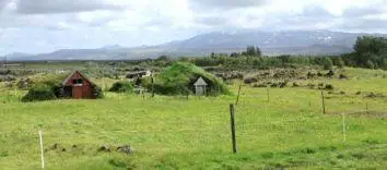
Figure I.3. Traditional sheepfolds in southern Iceland with the volcano Hekla in the background (Rangavellir) (Brigitte Van Vliet-Lanoë©)
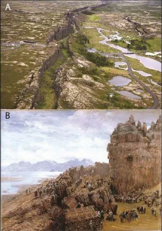
Figure I.4. (A) The Þingvellir graben, seen from an airplane (Þingvellir National Park Web site). The Alþing site is located in front of the white buildings (chapel). (B) Reconstruction of the Alþing in the Middle Ages by W.G. Collingwood (1897)
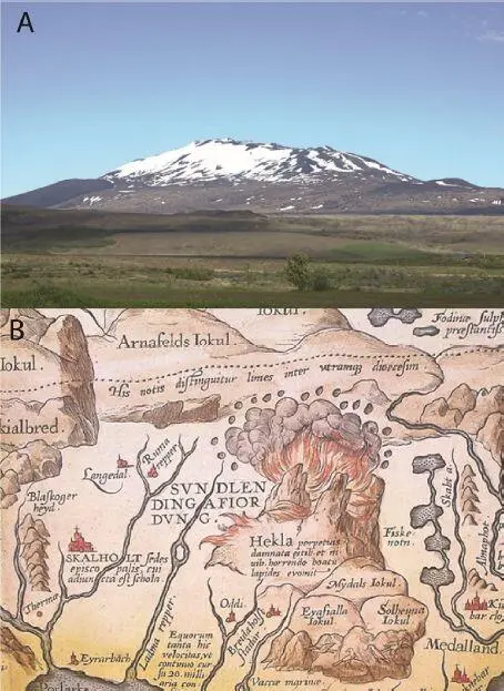
Figure I.5. (A) The Hekla volcano (Brigitte Van Vliet-Lanoë©) and (B) its cartographic representation on the map Islandia of Ortelius (1585)
Despite the island’s long isolation from continental Europe, there is a lot of information about its history. Indeed, Icelanders have jealously preserved their language and ancient books, including the famous sagas, and have often proved to be great writers and avid readers, even on isolated farms.
In addition to their literary and historical interest, the sagas represent a source of exceptional paleo-environmental information on a period whose climatic evolution was very complex: the Medieval Optimum and the climatic degradation that followed. The University of Iceland was founded in 1911 and, due to its special nature, Iceland is the country with the highest proportion of geologists and especially volcanologists among its population.
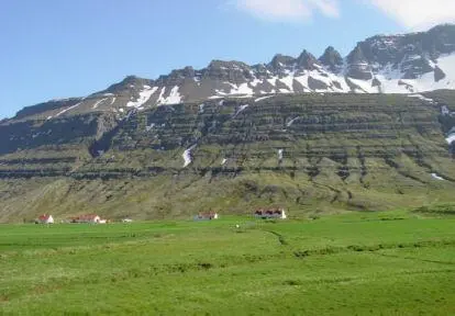
Figure I.6. Typical landscape of ancient basalts on the eastern coast of Iceland (Skridalur) (Brigitte Van Vliet-Lanoë©)
Iceland is a land of fire and ice, still sparsely populated (about 350,000 inhabitants in 2020), prized by tourists for its “unspoiled”, photogenic character and its many natural wonders, although Viking colonization quickly made the forest disappear. But recent tourist development has also caused an invasion of 4×4 vehicles, brand new hotels and vacation huts, raising the standard of living of the population, but gradually destroying a natural heritage – including the geological heritage – surprisingly well preserved until the early 21st century. Industrial development (geothermal, hydroelectricity and electrometallurgy) kept the population in the peripheral sectors of the island and above all modified the landscape of the coastal zones. Whatever one does or looks at in Iceland is de facto connected to the geological history of the island ( Figure I.6).
Despite its remoteness, Iceland is a land that directly influences Western Europe through its position in the north-central Atlantic, as a beacon of the Gulf Stream and thermohaline circulation, or through its meteorological depression. But it is also a land consisting mainly of layered basaltic piles, still active from a tectonic and volcanic point of view. We were reminded of it by the last eruption of the Eyjafjallajökull (March–October 2010) with its plume of ash that invaded Europe and disrupted intercontinental commercial flights ( Figures I.7and I.8).
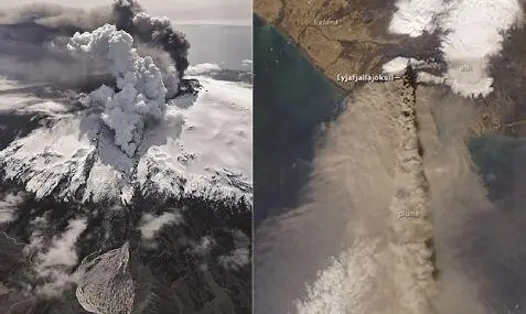
Figure I.7. The eruption of the Eyjafjallajökull in 2010: its jökulhlaup (Reykjavik Helicopter©) and plume (Earth Observatory, NASA)
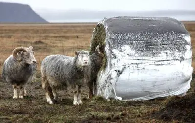
Figure I.8. Sheep disturbed by the ash from the eruption (Flickr©)
The glaciers are located on volcanic edifices, considered to be at least Quaternary. The largest ice cap, the Vatnajökull, rests on some of the most active volcanoes of the island, located above the summit of a deep magma plume.
Bárðarbunga ( Figure I.9) is one of the volcanoes found above the Icelandic hotspot and is located on the western margin of the present Vatnajökull ice cap.
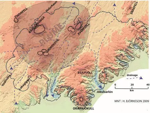
Figure I.9. Digital terrain model of Vatnajökull (black line: current cap boundary) completed with the flood drainage positioning and the potential extension (to a depth of 200 km) of the Icelandic mantle plume (in gray) (source: H. Björnsson, 2009)
The most recent eruption of this volcano (August 2014–February 2015; Figure I.10) was linked to the draining of a magma chamber located 12 km below the caldera, following the climate driven melting of the cap (about 1 m/year).
To the northwest, the most impressive lava flow since the 18th century, the Holhurhaun flow, occurred along a fracture line, in association with swarms of earthquakes that stretched to the Askja volcano in the north. The previous eruption, that of Veiðivötn, had flown toward the south in 1747, awakening the Torfa volcano at the same time.
The Bárðarbunga is also a source for jökulhlaups or megafloods, resulting from the melting of the glaciers by the heat of the lava emitted and which mostly flow toward the north.
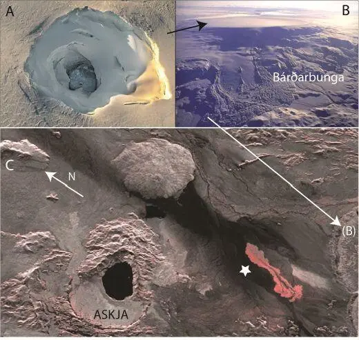
Figure I.10. (A and B) Views of the Bárðarbunga caldera obliterated by ice during the 2014 eruption with a melting cauldron to the west (A and black arrow) (photo: mbl.is/RAX). (C) Satellite image of the emersion of the Holhurhaun flow (star) on August 13, 2014 at the foot of the Bárðarbunga (B) (photo: TerraSAR-X)
Another major volcanic structure is located in the center of the ice cap, directly above the top of the mantle plume: it is the triple caldera of Grímsvötn ( Figures I.9and I.11), which emitted the vast majority of basaltic tephra that hide the glaciers and reach the lands surrounding the North Atlantic.
The most famous is the Saksunarvatn tephra splayed around 10,200 years cal BP. This volcano is never at rest; its current eruptive frequency is about 10 years and it also remained continuously active during the Ice Age, but with a lower frequency.
It is mainly responsible for the formation of subglacial lakes and is at the origin of most of the jökulhlaups that gully the emissaries of the Vatnajökull cap ( Figures I.12and I.13). At present, these floods mainly destroy road infrastructures such as the Main Highway (N1).
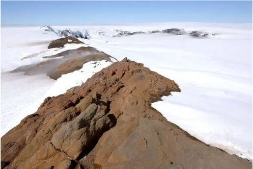
Figure I.11. Rim of the northern caldera of Grìmsvötn (Ragnar Sigurdsson©)
In northern Iceland, volcanic activity is also significant, in association with the northern rift. Many geothermal fields are exploited there, such as the Krafla field northeast of Lake Myvatn ( Figures I.14and I.15).
Читать дальшеИнтервал:
Закладка:
Похожие книги на «Iceland Within the Northern Atlantic, Volume 2»
Представляем Вашему вниманию похожие книги на «Iceland Within the Northern Atlantic, Volume 2» списком для выбора. Мы отобрали схожую по названию и смыслу литературу в надежде предоставить читателям больше вариантов отыскать новые, интересные, ещё непрочитанные произведения.


Обсуждение, отзывы о книге «Iceland Within the Northern Atlantic, Volume 2» и просто собственные мнения читателей. Оставьте ваши комментарии, напишите, что Вы думаете о произведении, его смысле или главных героях. Укажите что конкретно понравилось, а что нет, и почему Вы так считаете.