Bernard Debarbieux - The Politics of Mapping
Здесь есть возможность читать онлайн «Bernard Debarbieux - The Politics of Mapping» — ознакомительный отрывок электронной книги совершенно бесплатно, а после прочтения отрывка купить полную версию. В некоторых случаях можно слушать аудио, скачать через торрент в формате fb2 и присутствует краткое содержание. Жанр: unrecognised, на английском языке. Описание произведения, (предисловие) а так же отзывы посетителей доступны на портале библиотеки ЛибКат.
- Название:The Politics of Mapping
- Автор:
- Жанр:
- Год:неизвестен
- ISBN:нет данных
- Рейтинг книги:4 / 5. Голосов: 1
-
Избранное:Добавить в избранное
- Отзывы:
-
Ваша оценка:
The Politics of Mapping: краткое содержание, описание и аннотация
Предлагаем к чтению аннотацию, описание, краткое содержание или предисловие (зависит от того, что написал сам автор книги «The Politics of Mapping»). Если вы не нашли необходимую информацию о книге — напишите в комментариях, мы постараемся отыскать её.
The Politics of Mapping — читать онлайн ознакомительный отрывок
Ниже представлен текст книги, разбитый по страницам. Система сохранения места последней прочитанной страницы, позволяет с удобством читать онлайн бесплатно книгу «The Politics of Mapping», без необходимости каждый раз заново искать на чём Вы остановились. Поставьте закладку, и сможете в любой момент перейти на страницу, на которой закончили чтение.
Интервал:
Закладка:
What do citizens expect from cartographic experts? What we are increasingly seeing is that citizens are asking for training that empowers them to play a role in urban planning or development issues, and, more generally, spatial identity and development. They do not want to receive a lesson or an ideological message, but want to be supported in a process of expanding their capabilities (Sen 2010; Lévy et al . 2018).
In Medellín (see Figure 1.10), members of a neighborhood committee are asking academics to teach them how to produce and read maps, so that they can discuss the issues as equals with the local government, urbanists and other actors in urban society. To be fully effective, mapmakers must unapologetically abandon their engineering role and construct another, which consists not only of making themselves available, but also in adjusting their technicality (and especially their language) to the specificities of the issues and political scenes. The pluralism intrinsic to all political life also requires the plurality of cartographic projects and not just the variation of locations on a standardized base map. The commensuration of all of these citizen cartographies is not the point of departure, but the point of arrival, to be invented, of the public debate.
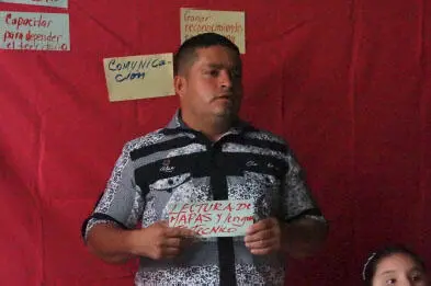
Figure 1.10. Citizen Mapping in Medellín, 2016 (source: original photograph by Jacques Lévy)
Like all political mediators, cartographers must accept the fact that they are actors in a world of actors. They are only actors among others, many others make maps and corporatist defenses are no longer appropriate. Maps circulate in a horizontal universe where no one can afford to address others as if they are in a dominant position.
In the old system, as it existed in the West in the 19th and 20th centuries, the pairing of cartographers with those of political or economic power dominated the scene. Innovations were emerging, such as the gradual emergence of a “thematic cartography”, which took the map out of the “headquarters”, but two significant limitations constrained the creativity of the field. First, a positivist epistemological paradigm gave the illusion that drawing a map was only about reproducing an already existing reality, and not about choosing a point of view and defining a method. This led to an impoverishment of languages and a belief that the Earth and the World only needed Euclidean geometry to be represented. Second, the concentration of cartographers in “countries”, those territories that are continuous inwardly and bounded outwardly, which constituted the privileged horizon of their “clients”, delayed the realization that networks constitute both the basic fabric of spaces and the fundamental spring of spatialities. This willful blindness has even diverted, until recently, the curiosity of specialists from the interest they should have shown in the remarkable achievements of Arab-Persian cartography from a thousand years ago. The impressive history of cartography launched by Harley and Woodward (1987–2015) has fortunately helped to show the extraordinary richness of the world’s cartographic culture. It was necessary to wait for the instructions for use, a geography inserted in a renewed science of the social capable of linking spatial productions, of which maps are obviously a part, and increasingly massively thanks to digital technology, to other human productions.
Ordinary citizens have been invited to the map table. Like everyone else, they need to acquire a minimum amount of technical skills to have access to the language of maps, but their arrival cannot be said to have “lowered the level” of communication in this field: quite the opposite, in fact. They also bring a breath of fresh air because they come with questions and are, moreover, quite capable of arguing if answers are proposed to them.
For all of these reasons, cartographic engineering is changing in nature and status. As can be observed in another field of spatial “technology”, urban action, cartographers and urban planners are no longer “experts” with all of the answers, but rather mediators with specific cognitive skills between inhabitants, habitability, for which politicians, including citizens, are responsible, and inhabitation, which society implements.
The relations between maps and politics are multiple. In this chapter, the themes of geopolitical propaganda, spatial ideologies, electoral geography, urban planning and citizen democracy show the multiplicity of the subject. In all cases, they raise the question of the specific role of the cartographer, whether they are a technician or a researcher. They must define their own place as a producer of knowledge without taking the place of citizens. This distinction in turn opens up a debate common to all on the ethics of knowledge and communication. The cartographer is not only someone through whom information passes, they are also the one who produces and disseminates it, which places on their shoulders, a responsibility commensurate with the questions and answers of which the act of drawing a map is an integral part. The cartographer’s contribution may sometimes seem modest, but it should never be underestimated because it is a part of the long chain of production, interpretation and action, of which the map is an increasingly present link.
While reinforcing the specificity and richness of its language, cartography has become established in the political scene and now plays a major role in the emergence and dynamics of its issues. A new, more open and more demanding age is therefore upon us.
1.7. References
Barker, R.G. (1968). Ecological Psychology: Concepts and Methods for Studying the Environment of Human Behavior . Stanford University Press, Stanford.
Bénit-Gbaffou, C. (2005). Politique des transports collectifs et démocratie locale à Los Angeles : entre participation et fragmentation. Flux , 2, 6–22.
Bénit-Gbaffou, C., Fol, S., Pflieger, G. (2007). Le front anti-métro en Californie. Controverses autour des politiques de transport en commun. L’Espace geographique , 36(2), 115–130.
Calbérac, Y., Lazzarotti, O., Lévy, J., Lussault, M. (2019). Carte d’identités. L’espace au singulier . Hermann, Paris.
Chavinier, E. and Lévy, J. (2009). Minarets : malaise dans l’alteridentité. EspacesTemps.net [Online]. Available at: https://www.espacestemps.net/articles/minarets-malaise-dans-alteridentite.
Collignon, B. (2002). Les toponymes inuit, mémoire du territoire. Étude de l’histoire des Inuinnait. Anthropologie et Sociétés , 26(2–3), 45–69.
Debarbieux, B. (2015). L’espace de l’imaginaire. Essais et détours . Éditions du CNRS, Paris.
Desbiens, C., Rivard, É., Hirt, I. (2017). Nous nous souvenons du territoire : la géographie québécoise face aux mémoires autochtones. Cahiers de géographie du Québec , 61(173), 293–313.
Elden, S. (2013). The Birth of Territory . University of Chicago Press, Chicago.
Ferry, J. M. (1991). Les puissances de l’expérience : le sujet et le verbe . Le Cerf, Paris.
Foucault, M. (1977). Vérité et pouvoir : entretien avec Fontana, M. L’Arc , 70, 16–26.
Frelat-Kahn, B. and Lazzarotti, O. (2012). Habiter : vers un nouveau concept . Armand Colin, Paris.
Gibson, J.J. (1977). The theory of affordances. In Perceiving, Acting, and Knowing: Toward an Ecological Psychology , Shaw, R. and Bransford, J. (eds). Lawrence Erlbaum Associates Inc, Hillsdale.
Читать дальшеИнтервал:
Закладка:
Похожие книги на «The Politics of Mapping»
Представляем Вашему вниманию похожие книги на «The Politics of Mapping» списком для выбора. Мы отобрали схожую по названию и смыслу литературу в надежде предоставить читателям больше вариантов отыскать новые, интересные, ещё непрочитанные произведения.


Обсуждение, отзывы о книге «The Politics of Mapping» и просто собственные мнения читателей. Оставьте ваши комментарии, напишите, что Вы думаете о произведении, его смысле или главных героях. Укажите что конкретно понравилось, а что нет, и почему Вы так считаете.