Bernard Debarbieux - The Politics of Mapping
Здесь есть возможность читать онлайн «Bernard Debarbieux - The Politics of Mapping» — ознакомительный отрывок электронной книги совершенно бесплатно, а после прочтения отрывка купить полную версию. В некоторых случаях можно слушать аудио, скачать через торрент в формате fb2 и присутствует краткое содержание. Жанр: unrecognised, на английском языке. Описание произведения, (предисловие) а так же отзывы посетителей доступны на портале библиотеки ЛибКат.
- Название:The Politics of Mapping
- Автор:
- Жанр:
- Год:неизвестен
- ISBN:нет данных
- Рейтинг книги:4 / 5. Голосов: 1
-
Избранное:Добавить в избранное
- Отзывы:
-
Ваша оценка:
The Politics of Mapping: краткое содержание, описание и аннотация
Предлагаем к чтению аннотацию, описание, краткое содержание или предисловие (зависит от того, что написал сам автор книги «The Politics of Mapping»). Если вы не нашли необходимую информацию о книге — напишите в комментариях, мы постараемся отыскать её.
The Politics of Mapping — читать онлайн ознакомительный отрывок
Ниже представлен текст книги, разбитый по страницам. Система сохранения места последней прочитанной страницы, позволяет с удобством читать онлайн бесплатно книгу «The Politics of Mapping», без необходимости каждый раз заново искать на чём Вы остановились. Поставьте закладку, и сможете в любой момент перейти на страницу, на которой закончили чтение.
Интервал:
Закладка:
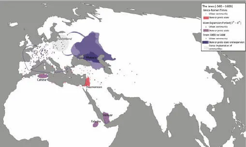
Figure 1.3. A recent historical approach to Jewish history (-300–1600) (source: map by E. Chavinier and J. Lévy in Lévy (2015, pp. 178–179))
The notion of a regime of truth, developed by Foucault (1977), can be useful in getting away from simplistic dichotomies. The hypothesis that truth is inscribed in a series of regimes does not aim, against a common belief, for a relativization of truth as such. On the contrary, it helps to show the complexity of the pathways to truth. And truth is ultimately found as the construction of a statement that maintains a clear homology, according to principles of evaluation fixed in advance, with a reality of reference external to this statement. Scientific research imposes a regime of truth on itself, based on coherence (no internal contradiction in the statement), relevance (a search for indicators ensuring an unequivocal link between the theory and the empirical), refutability and communication with all pre-existing or alternative propositions. Esthetics offer other regimes in which the discourse/actual homology is more vague, but not non-existent, and where refutability is replaced by fuzzier modes of validation, leaving room for the subjectivity of the receiver. Art and science can be considered as two cognitive modalities producing truth by being situated on a rational or on an esthetic side (Lévy and Sartoretti 2018). The technical truth regimes that can be summarized by the idea of plan, whether organizational, collective or personal, find their specificity in the fact that the judgment on the correspondence between referent and referred is the achievement of the plan itself. In the affective world, the circulation between the layers of the self (intimacy) produces situations in which the world of sensations and feelings, however autonomous it may be, interacts with the individual’s cognitive practices: self-awareness, self-lucidity or hybrids between projects and affective life are common expressions of these interactions. Finally, although the ethical, political and legal worlds do not fundamentally belong to the cognitive sphere and are not intended to produce truth, they are not totally alien to it, because of the strongly argumentative nature of public debates. Thus, a citizen cannot convince another citizen by simply asserting his/her support for one value or public policy over another. They must work to demonstrate that, if they are followed, positive effects will be felt by society as a whole. We can therefore consider that there are specific regimes of truth in the world of affects, interpersonal or ethico-political.
The crude dichotomy between true and false maps is of course still strong when it comes to factual errors or deliberate manipulation of data. For the rest, it appears to be the heir of an era when cartography belonged to the imagination of a weakly reflexive positivist engineering: it was believed that there was one “true map”, satisfying the mathematical rules of projection and geolocalization, and all of the others were false. If, on the other hand, we see all maps as true, each in their own way, as can be said, for example, of the discourses of people answering semi-structured interviews as part of scientific surveys, we have a large corpus on which we can propose statements concerning the regime of truth (intentional lying then being, unquestionably, a specific case), but also other aspects, which can unite or separate these different images according to various criteria.
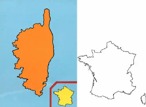
Figure 1.4. Truths of scale between Corsica and mainland France (source: postcard, Corsica, 1990s; map outline: https://www.rendlemanhome.com/carte-de-la-france-muette.html)
When we observe a map like this one (see Figure 1.4), it is not so easy to say if it is true or false at first, as the humor which is at the base of its conception plays an essential role and blurs the boundaries of simple classifications. Moreover, this map does not only belong to the universe of technical or scientific truth: it also has ethico-political dimensions (affirmation of the Corsican identity, influence of Corsica in French political life) and esthetic dimensions (effective simplicity of the information economy, effect of the scale inversion). The result is an awareness that, however elementary its design, a map conceals a wealth of meanings that researchers can work with to transform its complexity.
1.3. The new spaces of the electoral map
The above remarks may help in addressing political maps with the required openness. Geopolitics often pushes the notion of truth to its limits (Raffestin et al . 1995), and the mapping of inter-state rivalries consists more of a clash of lies, especially concerning the “historical rights” of a particular state over a particular territory, with political maps featuring the competition of truths.
The case of the mutation of electoral spaces in the West allows us to understand this difference. This new configuration, which is omnipresent and massively recurrent, is so clear that it can be formalized simply by means of two equations 1(Lévy 2020). Its legibility is improved by the use of cartograms. While a Euclidean base map relies on the geometric homology between angles, lengths or surfaces on the space to be represented and on the map, the cartogram opens up the range of possibilities by making the map surfaces correspond to any series of geolocalized variables of the reference reality – population, production, etc. – while respecting a few topological rules (each spatial unit remains well surrounded by its neighbors), which makes it possible to maintain a cartographic relationship between the image and the reality it represents.
Almost everywhere, and with very few exceptions, votes in favor of various types of openness to otherness are clearly more numerous in highly urban areas, those with a powerful combination of density and diversity, such as the centers of large cities, and become weaker as the level of urbanity decreases. This new geographical situation reverses long-standing electoral traditions that were organized more on a regional scale. The shift became visible in the early 1990s, in specific issues, such as the referendums on European construction or the questions of immigration, sexual orientation or religion. It then deepened when the tribune parties that fed on these issues gained influence. Finally, from the early 2000s in the United States, and in the following decade in Europe, it became a generalist marker: the major elections that decide on the major political choices of societies fall within this geographical model. Here, some examples are discussed (see Figures 1.5– 1.9).
The first pair (see Figures 1.5and 1.6), which concerns France, shows that the configuration of the 2017 presidential election was already present, almost identically, in that of the 1992 referendum on the Maastricht Treaty. In both cases, three different scales appear to be relevant: large regions; urban areas, with a strong opposition between cities and the suburban countryside; and, in a more complex way, city centers and part of the suburbs.
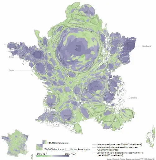
Figure 1.5. The French referendum of September 20, 1992 on the Maastricht Treaty (source: Lévy et al. 2017)
Читать дальшеИнтервал:
Закладка:
Похожие книги на «The Politics of Mapping»
Представляем Вашему вниманию похожие книги на «The Politics of Mapping» списком для выбора. Мы отобрали схожую по названию и смыслу литературу в надежде предоставить читателям больше вариантов отыскать новые, интересные, ещё непрочитанные произведения.


Обсуждение, отзывы о книге «The Politics of Mapping» и просто собственные мнения читателей. Оставьте ваши комментарии, напишите, что Вы думаете о произведении, его смысле или главных героях. Укажите что конкретно понравилось, а что нет, и почему Вы так считаете.