Helen Dunmore - The Crossing of Ingo
Здесь есть возможность читать онлайн «Helen Dunmore - The Crossing of Ingo» — ознакомительный отрывок электронной книги совершенно бесплатно, а после прочтения отрывка купить полную версию. В некоторых случаях можно слушать аудио, скачать через торрент в формате fb2 и присутствует краткое содержание. Жанр: unrecognised, на английском языке. Описание произведения, (предисловие) а так же отзывы посетителей доступны на портале библиотеки ЛибКат.
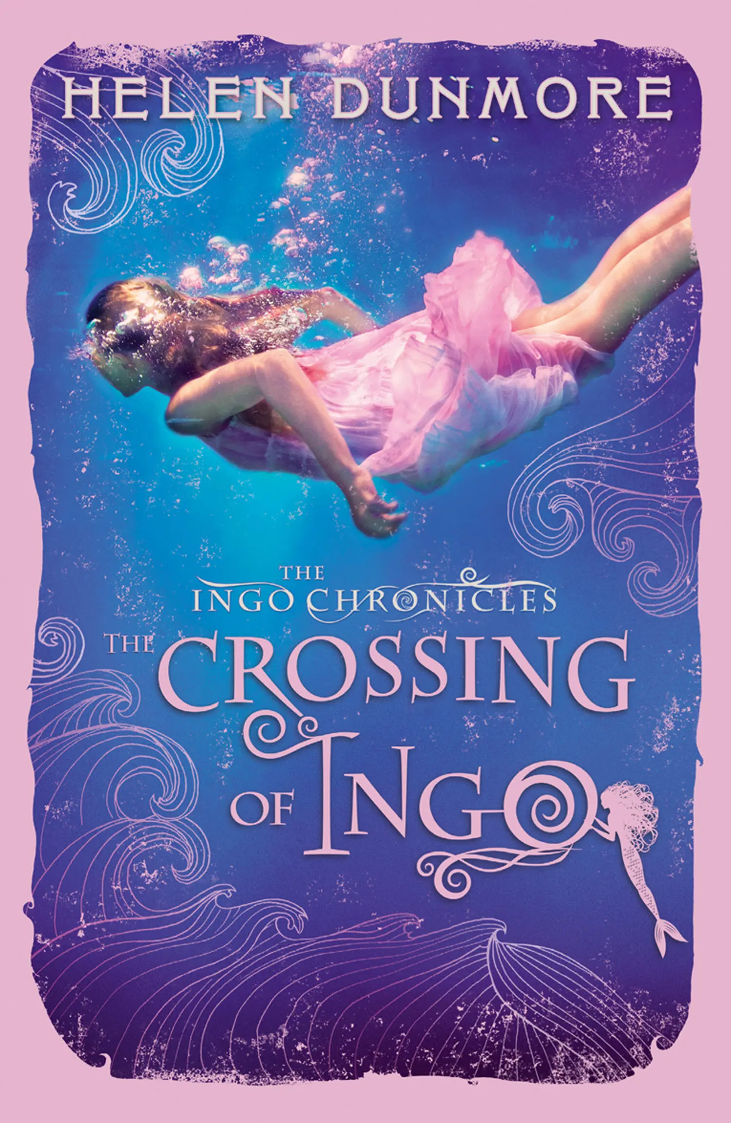
- Название:The Crossing of Ingo
- Автор:
- Жанр:
- Год:неизвестен
- ISBN:нет данных
- Рейтинг книги:5 / 5. Голосов: 1
-
Избранное:Добавить в избранное
- Отзывы:
-
Ваша оценка:
The Crossing of Ingo: краткое содержание, описание и аннотация
Предлагаем к чтению аннотацию, описание, краткое содержание или предисловие (зависит от того, что написал сам автор книги «The Crossing of Ingo»). Если вы не нашли необходимую информацию о книге — напишите в комментариях, мы постараемся отыскать её.
The Crossing of Ingo — читать онлайн ознакомительный отрывок
Ниже представлен текст книги, разбитый по страницам. Система сохранения места последней прочитанной страницы, позволяет с удобством читать онлайн бесплатно книгу «The Crossing of Ingo», без необходимости каждый раз заново искать на чём Вы остановились. Поставьте закладку, и сможете в любой момент перейти на страницу, на которой закончили чтение.
Интервал:
Закладка:
“But that’s not five oceans, Dad, that’s seven.”
“Ah well, the North and South Pacifics really only count as one, same with the Atlantics.”
If Mum was there she’d frown with annoyance. “Filling the child’s head with crazy ideas, getting her excited about things that will never happen. Why do you do it, Mathew?”
“Who’s to say what will happen and what won’t?” Dad would murmur, touching the globe again to make it spin.
I believed every word he said. The oceans seemed to belong to me already. I imagined Dad and me in the Peggy Gordon , cutting through the brilliant waves of the Southern Ocean. We’d discover a rake of tiny islands scattered across the water like stars in a deep blue sky. We would catch fish to eat and when our jerry cans were empty we’d steer for a green island to fill them up with fresh water from a little bubbling spring. We would pull the Peggy Gordon up on a beach at evening and maybe curious people would come down to talk to us. We’d eat and drink with them, and Dad would trade songs with the island singers…
Conor traces a line between Cornwall and the huge continent of Australia. His finger travels around the western bulge of Africa, past the Cape and eastwards across the Indian Ocean. How easy the journey looks when you’ve only got to turn a globe. To the bottom of the world and home again in a few seconds. But it won’t be like that for us.
“It’s so far,” I say.
“I know,” replies Conor.
“It’s quite – quite scary, isn’t it?”
“Yeah. You know that time I went climbing on the cliffs with Jack up by Godrevy, near Hell’s Mouth? I never told you what happened. We got stuck. Couldn’t go back, couldn’t go on without kind of jumping and throwing ourselves on to the next handhold. The sea was boiling down below.”
“You should have told me,” I say.
“Yeah, well, I didn’t want to scare you. In the end we had to do the jump. Jack was in front of me so he went first and I had to watch him. Worst moment of my life. Well, nearly the worst.”
“But he didn’t fall.”
“Course he didn’t, idiot. He’s still alive, isn’t he? After that bit, it was easy.”
“So once we set out it’ll be easier.”
“Maybe.”
Later, when Conor has gone up to the farm for the eggs, I go to the chest where Dad stored his prints and negatives. The chest has six long, shallow drawers which glide in or out at the touch of a finger. I go to the fifth drawer down and slide it open.
I haven’t looked in this drawer since Dad went away. Nothing’s changed. Dad’s drawers were always kept ship-shape. I slide my hand to the very back, and my fingers touch a familiar, fragile roll of parchment. It just fits the shallow drawer.
I take out Dad’s map. I don’t know why I call it “Dad’s map” really because he always called it “the Trewhella map” or “our map”. But I associate it with him because we spent so many hours together poring over it. It’s very old. A length of faded black tape ties the rolled-up map. The parchment is yellow brown and stained. I used to think the brown stains were blood, but Dad said they were just where sea water had darkened the parchment. This map has travelled the oceans, Sapphy. It’s been in our family for hundreds of years.
We can’t display the map on a wall because it has to be kept away from the light, which would quickly fade the outlines and the writing. Besides, Dad always said such a map is a private thing. You don’t want outsiders to ask questions, or tell you that it ought rightly to be in a museum. This map was made by Trewhellas, Sapphy. It’s to be kept with the Trewhellas.
I untie the black tape. I know what’s inside so well that I wait for a moment, not unrolling the map but letting every detail of it rise to my mind. It’s a map of the world, but not like any you could buy now. At each pole there is a vast prowling mass of icy land. In the centre of the Arctic mass a jagged black rock rises sharply from the whiteness. It is marked The North Pole. Our map was drawn at the time when people thought there was solid land at the North Pole, not a mass of frozen sea.
Australia doesn’t appear on the map at all. Where it should be, there’s a sheet of empty ocean. The shape of South America is wrong, much shorter and wider than it really is. California is an island. The British Isles are drawn out of proportion, and there are beautiful tiny drawings of sailing ships making way out of London and Bristol. The European part of the map is detailed and complete with rivers and mountain ranges, but the northwest of America and the east of Russia and China are vast unmarked territories, enclosed by uncertain lines. It looks as if the mapmaker was guessing at the boundaries.
When I first saw the map I didn’t question it. It was Dad’s map, so it must be correct. I even told my teacher that the world map on our classroom wall was wrong, but he said that mapmakers these days had satellite photographs to make their maps absolutely accurate. The next time Dad let me look at his map I felt as if it had tricked me. I said, “Dad, they’ve got it wrong on your map. Africa doesn’t go like that. And look, they haven’t even put Australia and New Zealand in.”
Dad said, “Those men who risked their lives to make this map weren’t stupid, Sapphy. This is their world. They drew what they knew.”
“But they’ve put sea dragons in the ocean. And look, there’s a man spouting water and blowing on a seashell.”
“That’s Neptune, Sapphy. God of the sea.”
“But maps ought to show real things. There aren’t any real dragons.” I was at the age when you’re proud of knowing that there are no such things as dragons and fairies.
Dad said, “Maybe there were dragons then. Don’t make the mistake of thinking that your ancestors knew less than you do, Sapphy.”
“The map’s wrong, though. We’ve got satellite pictures nowadays. We know what the Earth really looks like.”
Dad laughed scornfully. “You don’t learn what the world is like by looking at a picture that’s been sent from a piece of metal and plastic orbiting miles above the Earth’s atmosphere. Think of all the salt seas they fought across to make our map, and all the storms they weathered in a wooden ship that you wouldn’t believe could sail as far as France.”
The map is old and very fragile. Even the careless touch of a human hand can damage it, Dad used to say. Carefully, as he taught me, I unroll it and spread it out on the table. A piece of paper falls out. Not old parchment like the map. Twenty-first century paper, folded. My heart jumps with excitement. All at once I’m certain that this is a message, hidden by Dad for me to find. I was always the one who wanted to see the map, not Conor. I pick up the paper and unfold it, my fingers trembling. But there’s nothing to be excited about. Just a few scribbled figures.
22 30 7 6
23 00 9 6
23 15 15 6
23 30 19 6
It’s Dad’s handwriting. The sight of it hurts me. I don’t want to think about Dad’s hand picking up the pen and writing these figures. It must have been important or he wouldn’t have bothered to put the paper inside the map. I look at the figures again, trying to add them up and guess their meaning. They refuse to give up their secret.
I turn back to the map, and weigh down its corners with the smooth pebbles Dad always used for the purpose. Automatically my gaze goes to the place where we live. The coast of Cornwall is beautifully drawn by someone who knows every cove. The mapmaker has made Cornwall look a lot bigger than it really is in proportion to the rest of the British Isles. Dad said there was a reason for that too. If you’re making a map, you might make more of something that’s important to you.
Читать дальшеИнтервал:
Закладка:
Похожие книги на «The Crossing of Ingo»
Представляем Вашему вниманию похожие книги на «The Crossing of Ingo» списком для выбора. Мы отобрали схожую по названию и смыслу литературу в надежде предоставить читателям больше вариантов отыскать новые, интересные, ещё непрочитанные произведения.
Обсуждение, отзывы о книге «The Crossing of Ingo» и просто собственные мнения читателей. Оставьте ваши комментарии, напишите, что Вы думаете о произведении, его смысле или главных героях. Укажите что конкретно понравилось, а что нет, и почему Вы так считаете.