Francis Pryor - Britain in the Middle Ages - An Archaeological History
Здесь есть возможность читать онлайн «Francis Pryor - Britain in the Middle Ages - An Archaeological History» — ознакомительный отрывок электронной книги совершенно бесплатно, а после прочтения отрывка купить полную версию. В некоторых случаях можно слушать аудио, скачать через торрент в формате fb2 и присутствует краткое содержание. Жанр: unrecognised, на английском языке. Описание произведения, (предисловие) а так же отзывы посетителей доступны на портале библиотеки ЛибКат.
- Название:Britain in the Middle Ages: An Archaeological History
- Автор:
- Жанр:
- Год:неизвестен
- ISBN:нет данных
- Рейтинг книги:3 / 5. Голосов: 1
-
Избранное:Добавить в избранное
- Отзывы:
-
Ваша оценка:
Britain in the Middle Ages: An Archaeological History: краткое содержание, описание и аннотация
Предлагаем к чтению аннотацию, описание, краткое содержание или предисловие (зависит от того, что написал сам автор книги «Britain in the Middle Ages: An Archaeological History»). Если вы не нашли необходимую информацию о книге — напишите в комментариях, мы постараемся отыскать её.
Britain in the Middle Ages: An Archaeological History — читать онлайн ознакомительный отрывок
Ниже представлен текст книги, разбитый по страницам. Система сохранения места последней прочитанной страницы, позволяет с удобством читать онлайн бесплатно книгу «Britain in the Middle Ages: An Archaeological History», без необходимости каждый раз заново искать на чём Вы остановились. Поставьте закладку, и сможете в любой момент перейти на страницу, на которой закончили чтение.
Интервал:
Закладка:
It is possible to view the growth and development of individual British ‘productive’ sites in two ways. They might have sprung up as trading centres because of their location close to rivers and roads. Prehistorians have found that a safe or ‘neutral’ position at some distance from a large centre of population might help in the establishment of such a place, where trade and exchange could happen with some assurance of security. After a while the trading post would grow as a settlement and soon it would acquire other facilities, such as the provision of justice, administration and financial services – a mint, for example.
But there is another way of looking at the situation. J.D. Richards, basing his remarks on fieldwork he carried out at Cottam, a ‘productive’ site in East Yorkshire, wonders whether we are placing the cart before the horse by putting so much stress on the productiveness of ‘productive’ sites. 23 He asks whether, if they had been found by more conventional archaeological techniques, they would simply have been seen as important regional communal centres – rich settlements, in other words. Although he seems at first glance to be taking a less dramatic, and rather more conventional, view of the period, I find his ideas ring archaeologically true. His suggestion is persuasive because it helps to demystify the concept of ‘productive’ sites, which otherwise seem to lack a rationale.
It is not often that I come across an academic paper that excites me so much that its implications keep me awake at night, but it happened recently when I read Ben Palmer’s thoughts on emporia and ‘productive’ sites in southern England. 24 It happened to be the first chapter I read in Tim Pestell and Katharina Ulmschneider’s Markets in Early Medieval Europe: Trading and ‘Productive’ Sites, 650–850, a collection of essays that I have already drawn upon quite heavily and that will undoubtedly have a profound effect on the way we think about the archaeology of early medieval Europe for years to come. Palmer’s paper is original because it focuses on what used to be called inter-site (as opposed to intra-site) archaeology. Most archaeologists spend their time wondering how people led their lives or conducted ceremonies on one specific site. This inevitably follows the process of excavation, which is intensely focused and usually has the archaeologist ‘by the throat’ – I speak from personal experience. Plainly one looks at other sites for comparisons and parallels, but that tends to happen very late in the post-excavation period.
Such short-sighted introspection is discouraged if the information is coming from a number of separate places, and when detailed excavation and survey are usually not involved. The result is what the prehistorian Robert Foley termed ‘off-site archaeology’, where one studies what was happening between rather than on sites. This approach helps one to understand both what it was that held the network of sites together, and why the system appeared on the landscape in the first place. 25 Ben Palmer’s paper is an excellent example of the genre. He confines his attention to south-eastern England, the main region of rapid economic growth in the Middle Saxon period.
The first impression I had when I read Ben Palmer’s paper was of geographical ‘connectedness’. This paper could never have been written about prehistoric Britain, and it certainly did not resemble anything I knew on the archaeology of the post-Roman ‘Dark Ages’. These periods were simply too remote, and lacked the necessary information. It took just two centuries for that to change. The world he was discussing was a working, functioning trading system. We don’t know whether they had such things, but it would have been possible to compile road maps showing places where one could stay the night, get a meal and find fresh horses. It seems to me that the false emphasis on loot – on coins and ‘productive’ sites – tends to obscure the fact that Middle Saxon southern England was about more than just trade in objects from foreign parts: these networks were also about people living their daily lives – selling their wool, making their clothes and growing their food. We can now discern coherent trading landscapes where we can observe the relationship of the town to the countryside – and how each supported the other. To my eyes this paper showed the first signs of a geography that was recognisably modern.
There has been some debate as to whether the three major centres (emporia or wics) at Ipswich, Lundenwic (London) and Hamwic (Southampton) were ‘true’ towns, in the sense that they supported a large population and were self-governed. Pre-Viking York (Eoforwic) is another likely contender for wic status. Personally I’m in little doubt that these settlements were fully urban, as we would understand the term today, because I cannot see how places with such a density of settlement could survive and prosper in any other way. Further, a significant proportion of the population must have spent all their time being merchants or artisans. They would have had little or nothing to do with the production of food from the land.
But I will leave that particular discussion aside, because I’m not sure it’s either relevant or interesting. What matters is that these places are something altogether different from anything that had gone before: not only are they larger and richer, but they are positioned at key points in a much larger network of settlement, trade and communication. It cannot be a coincidence that they are all more or less the same distance apart, and straddle the south-eastern approaches, like the open mouth of a vast trawler net being slowly towed towards the North Sea. The traditional view of wics and emporia is that they were one-offs, isolated and before their time. Ben Palmer describes the old view of them as a failed experiment in kingdom-building. They owed their existence to the fact that they were ‘gateway communities’ that stood on the periphery of the developed core of western Europe, represented by Francia, the Empire of the Franks.
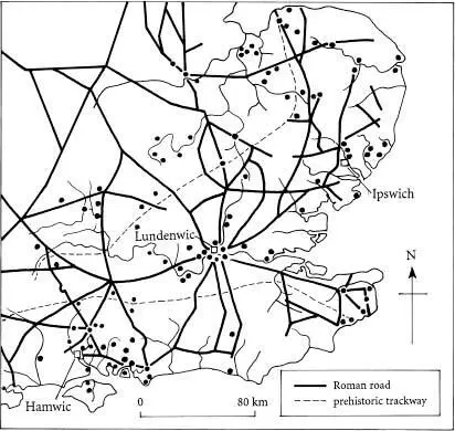
FIG 5 South-eastern England in the Middle Saxon period, showing the location of the three major centres (emporia or wics) at Ipswich, Lundenwic (London) and Hamwic (Southampton). ‘Productive’ sites and other significant settlements or trading centres are shown by dots .
Here I must briefly break off to say a few words about Charlemagne and the Franks. Charlemagne is often seen as the father of modern Europe, and his empire the true ancestor of the European Community. Jacques Le Goff takes a more sceptical view. For him, Charlemagne produced an abortive Europe that nevertheless left behind a legacy. 26 This is a view with which most archaeologists would probably agree.
The Franks were a Germanic people who expanded west across the Rhine in the late fifth and sixth centuries, under the command of their remarkable king Clovis (died c.511), to occupy most of central and eastern Gaul (France). This expansion was continued by their greatest emperor, Charles the Great, or Charlemagne (771–814). Under his leadership the Carolingian Empire was to occupy most of western Europe, excepting Spain and southern Italy. Charlemagne, who was barely literate himself, reformed and expanded the power of the Church and encouraged the development of art and letters. While he was in sole charge his empire was stable and very prosperous. The tradition of scholarship was continued by his successors Louis the Pious and Charles the Bald, but the old flair had gone, and Europe now entered a less stable period when political allegiances were shifting. By the mid-tenth century the driving force of the Carolingian Empire shifted towards Germany, with the accession of Otto I in 936.
Читать дальшеИнтервал:
Закладка:
Похожие книги на «Britain in the Middle Ages: An Archaeological History»
Представляем Вашему вниманию похожие книги на «Britain in the Middle Ages: An Archaeological History» списком для выбора. Мы отобрали схожую по названию и смыслу литературу в надежде предоставить читателям больше вариантов отыскать новые, интересные, ещё непрочитанные произведения.


Обсуждение, отзывы о книге «Britain in the Middle Ages: An Archaeological History» и просто собственные мнения читателей. Оставьте ваши комментарии, напишите, что Вы думаете о произведении, его смысле или главных героях. Укажите что конкретно понравилось, а что нет, и почему Вы так считаете.