Rosemary Parslow - The Isles of Scilly
Здесь есть возможность читать онлайн «Rosemary Parslow - The Isles of Scilly» — ознакомительный отрывок электронной книги совершенно бесплатно, а после прочтения отрывка купить полную версию. В некоторых случаях можно слушать аудио, скачать через торрент в формате fb2 и присутствует краткое содержание. Жанр: unrecognised, на английском языке. Описание произведения, (предисловие) а так же отзывы посетителей доступны на портале библиотеки ЛибКат.
- Название:The Isles of Scilly
- Автор:
- Жанр:
- Год:неизвестен
- ISBN:нет данных
- Рейтинг книги:3 / 5. Голосов: 1
-
Избранное:Добавить в избранное
- Отзывы:
-
Ваша оценка:
The Isles of Scilly: краткое содержание, описание и аннотация
Предлагаем к чтению аннотацию, описание, краткое содержание или предисловие (зависит от того, что написал сам автор книги «The Isles of Scilly»). Если вы не нашли необходимую информацию о книге — напишите в комментариях, мы постараемся отыскать её.
The Isles of Scilly — читать онлайн ознакомительный отрывок
Ниже представлен текст книги, разбитый по страницам. Система сохранения места последней прочитанной страницы, позволяет с удобством читать онлайн бесплатно книгу «The Isles of Scilly», без необходимости каждый раз заново искать на чём Вы остановились. Поставьте закладку, и сможете в любой момент перейти на страницу, на которой закончили чтение.
Интервал:
Закладка:
CLIFFS AND COASTS
Most of the coastland of St Mary’s consists of cliffs, not very high, but spectacular enough at times when gales drive the waves in onto the rocks. In places a few small bays break the coastline and there are two large promontories, the Garrison in the southwest and Peninnis Head in the south. In many places there are granite carns (tors) eroded into extraordinary, fantastical shapes: Pulpit Rock, Tooth Rock and the Loaded Camel are just a few well-known examples (Fig. 30). Above the cliffs and steep slopes along the west coast are typical maritime-cliff plant communities, dense bracken communities on the deeper soils, heather-dominated heath and short grassland on the shallower soils and over rocks. Among the shrub species growing on the coast are both common gorse Ulex europaeus and western gorse U. gallii and scattered patches of broom. Along the coastal edge the maritime grassland sometimes extends inland as a series of pastures that in summer are bright with the yellow flowers of common cat’s-ear Hypochaeris radicata amid a colourful mixture of grasses and forbs.
At Carn Morval, on the steepest part of the coast, part of the nine-hole golf course is perched on a rocky promontory above the slope. The rest of the
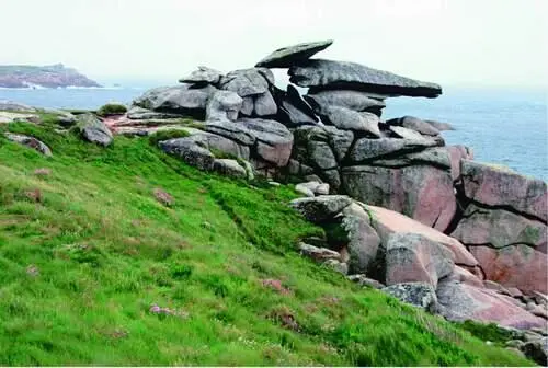
FIG 30.Pulpit Rock on Peninnis Head, St Mary’s, May 2006. (Richard Green)
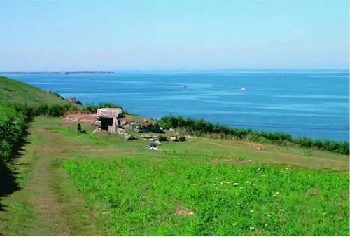
FIG 31.Bant’s Carn on Halangy Down, St Mary’s, probably the best known of the Bronze Age entrance graves in the Isles of Scilly. March 2006. (Rosemary Parslow)
golf course sits high above at the top of the slope, where its manicured greens frequently attract migrating birds. As with the airfield this can be very frustrating for the excluded birdwatchers! Beyond Carn Morval is another area of coastal heath at Halangy Down, where in a carefully tended area of grass and mown heather is an important archaeological site managed by English Heritage. These are the remains of an Iron Age/Romano-British village settlement of many small buildings, now marked only by low walls, and the ridges denoting earlier field systems on the nearby slopes. At the top of the hill is Bant’s Carn, a large Bronze Age entrance grave, one of the best examples of its type in Scilly (Fig. 31). The whole closely managed and mown site is quite species-rich, and even the walls and banks of the ancient village have an interesting flora that includes western gorse, hairy bird’s-foot-trefoil Lotus subbiflorus , subterranean clover Trifolium subterraneum growing on and among the stones. The turf is also full of chamomile Chamaemelum nobile , deliciously scenting the air as you explore. Ruts on some of the paths nearby have a miniature flora of toad rush Juncus bufonius and sometimes in spring an unusual but very inconspicuous alien called Scilly pigmyweed Crassula decumbens . This is a South African species, probably introduced accidentally with other plants to the nearby Bant’s Carn farm. Only very recently has it apparently started to spread away from the farm, and it can now sometimes be seen on the path leading up the hill towards the golf course.
Just beyond Bant’s Carn Farm the land slopes down to the sand dunes that form the northern tip of the island at Bar Point. The dune system is very disturbed. Part has been quarried and there is also a part used as a dump. Much of the dune system has become colonised by bracken and bramble Rubus agg. communities. There are areas of scattered gorse bushes, where both the rare balm-leaved figwort and Babington’s leek Allium ampeloprasum var. babingtonii can be found. Closer to the quarry and the dump some plants of garden origin have become established so that you can come upon bear’s breech Acanthus mollis , montbretia Crocosmia x crocosmiiflora , fennel Foeniculum vulgare and even the giant rhubarb plant Gunnera tinctori . Somewhere in the dunes near here the fern moonwort Botrychium lunaria used to grow under the bracken. It was last recorded by Lousley in 1940, and may have been lost when the area suffered major disturbance some time after 1954, from various activities including relaying the submarine telegraph cable, winning sand and dumping rubbish. Since then, despite much searching, there has been no further sign of the moonwort.
More areas of bracken communities follow the northern coast of the island all the way round from Bar Point to Innisidgen, Helvear Down, and right down to the narrow inlet at Watermill Cove. On this northern part of the coast there are areas of pine shelterbelts, which extend right round to the eastern side of the island, and large stretches of beautiful heathland near the coast. Patches of tall gorse with an understorey of lower heathland plants grow along the sides of the path as it continues around the coast, also appearing anywhere there are breaks in the bracken cover.
Close to the coast path are two impressive entrance graves, Innisidgen Upper Chamber and Innisidgen Lower Chamber. Around the barrows the vegetation is kept regularly mown, resulting in species-rich lawns of grasses, sedges and typical heathland plants, demonstrating the potential richness of the vegetation if the surrounding overgrown areas could be restored and perhaps maintained by grazing. Beside the path what appears to be a low wall is the remains of the former Civil War breastworks, half-buried in dense vegetation. As the path drops down the hill into Watermill Cove, the Watermill Stream runs into the sea through mats of dense hemlock water-dropwort, fool’s-water-cress Apium nodiflorum and a group of grey sallow Salix cinerea oleifolia trees. Just round the corner there are steep cliff exposures along the section of the inlet at Tregear’s Porth, an important geological site, notified as the Watermill Cove Geological Conservation Review site. From here the path continues along the coast, and another one follows the Watermill Stream inland along the heavily shaded lane lined with ferns.
The mosaic of heathland, gorse, bracken and bramble continues along the coast past Mount Todden. In places there are more sections of Civil War fortifications and much earlier archaeological sites. Below the cliffs at Darity’s Hole is a very important underwater site where many unusual marine species have been recorded. Towards Deep Point there is an area of ‘waved heath’ (see Chapter 10), and elsewhere there are patches of heather still beneath the taller bracken, as well as around rocks and paths. Where there is a freshwater seepage down one of the slopes, the understorey consists of broad buckler fern Dryopteris dilitata , occasional soft shield-fern Polystichum setiferum and marsh pennywort Hydrocotyle vulgaris . Near Deep Point in an area of short coastal turf careful searching may reveal another rare lichen, ciliate strap-lichen Heterodermia leucomela . It was at Deep Point that at one time the islanders disposed of cars and other rubbish over the cliff. Although the practice has been stopped, the remains of vehicles at the bottom of the cliff in deep water apparently now support a rich marine flora and fauna! At Porth Wreck there is a former quarry in the cliff, often the place to find unusual casual plants.
Porth Hellick Down is one of the largest areas of wind-pruned waved heath on St Mary’s. Much of the gorse among the heathers in the area is western gorse, with flowers a deeper golden colour than the yellow of common gorse. Around the Porth Hellick barrow Ancient Monument is a closely mown circle of grass starred with flowers of chamomile, tormentil Potentilla erecta and lousewort Pedicularis sylvestris , as well as stunted bell heather and other typical heathland plants. Similar vegetation covers the burial mound with a dense sward of low grasses and flowers.
Читать дальшеИнтервал:
Закладка:
Похожие книги на «The Isles of Scilly»
Представляем Вашему вниманию похожие книги на «The Isles of Scilly» списком для выбора. Мы отобрали схожую по названию и смыслу литературу в надежде предоставить читателям больше вариантов отыскать новые, интересные, ещё непрочитанные произведения.


Обсуждение, отзывы о книге «The Isles of Scilly» и просто собственные мнения читателей. Оставьте ваши комментарии, напишите, что Вы думаете о произведении, его смысле или главных героях. Укажите что конкретно понравилось, а что нет, и почему Вы так считаете.