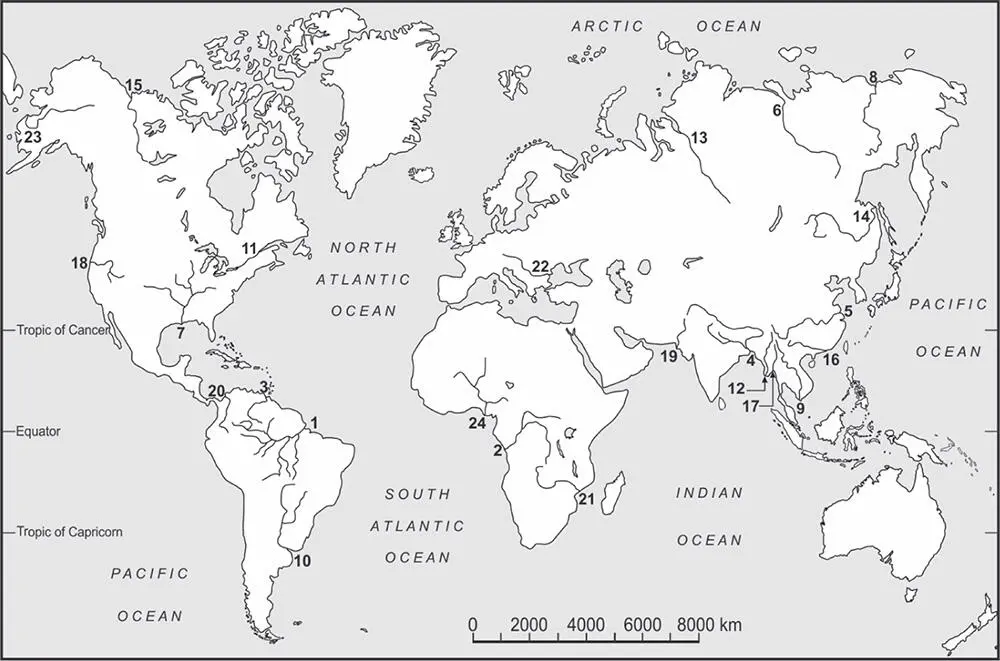
Based on the areal extent of their drainage basin, Potter (1978) examined 50 of the world's largest rivers, ranked by Inman and Nordstrom (1971), starting with the Amazon. All but one of these rivers are more than 10 3km long, and the smallest drainage basin is about 10 5km 2. These 50 rivers collectively drain about 47% of the land mass, excluding Greenland and Antarctica. The Amazon alone drains about 5% of the continental area. These rivers also have modified the physiography of a large part of the world. Table 1.1lists the top 24 large rivers ( Figure 1.1), ranked according to their average annual water discharge. Their ranks would change if the rivers were listed according to any of the other three properties.
There are other lists. Hovius (1998) tabulated the morphometric, climatic, hydrologic, transport, and denudation data for 97 river basins, all of which measured above 2.5 × 10 4km 2. Meade (1996) ranked the top 25 rivers twice: first, according to their discharge; and second, according to their suspended sediment load. The two lists do not match well. For example, large rivers such as the Zambezi or Lena carry a large water discharge but a low sediment load. Impoundments too have drastically reduced the once high sediment load of many rivers such as the Mississippi-Missouri. Over approximately the last 100 years, many rivers have been modified by engineering structures such as dams and reservoirs. The Colorado or the Huanghe (Yellow River) at present may not flow to the sea round the year. Such changes have also reduced the amount of sediment that passes from the land to the coastal waters. Large rivers such as the Nile or Indus have been associated with human civilisation for thousands of years and show expected modifications.
Table 1.1 Selected characteristics of 24 large rivers.
| River |
Average annual water discharge (10 6m 3) |
Length (km) |
Drainage basin area (km 2) |
Current average annual suspended sediment discharge (10 6t) |
| 1. Amazon |
6300 |
6000 |
5.9 |
1000–1300 |
| 2. Congo |
1250 |
4370 |
3.75 |
43 |
| 3. Orinoco |
1200 |
770 |
1.1 |
150 |
| 4. Ganga-Brahmaputra |
970 |
B-2900 G-2525 |
1.06 (B-0.63) |
900–1200 |
| 5. Changjiang |
900 |
6300 |
1.9 |
480 |
| 6. Yenisey |
630 |
5940 |
2.62 |
5 |
| 7. Mississippi |
530 |
6000 |
3.22 |
210 |
| 8. Lena |
510 |
4300 |
2.49 |
11 |
| 9. Mekong |
470 |
4880 |
0.79 |
150–170 |
| 10. Paranẚ-Uruguay |
470 |
3965 |
2.6 |
100 |
| 11. St. Lawrence |
450 |
3100 |
1.02 |
3 |
| 12. Irrawaddy |
430 |
2010 |
0.41 |
260 |
| 13. Ob |
400 |
>5570 |
2.77 |
16 |
| 14. Amur |
325 |
4060 |
2.05 |
52 |
| 15. MacKenzie |
310 |
4200 |
2.00 |
100 |
| 16. Zhujiang |
300 |
2197 |
0.41 |
80 |
| 17. Salween |
300 |
2820 |
0.27 |
About 100 |
| 18. Columbia |
250 |
2200 |
0.66 |
8 |
| 19. Indus |
240 |
3000 |
0.97 |
50 |
| 20. Magdalena |
240 |
1540 |
0.26 |
220 |
| 21. Zambezi |
220 |
2575 |
1.32 |
20 |
| 22. Danube |
210 |
2860 |
0.82 |
40 |
| 23. Yukon |
195 |
3200 |
0.83 |
60 |
| 24. Niger |
190 |
4100 |
2.27 |
40 |
These figures vary between sources, although perhaps given the dimensions, such variations are proportionally negligible. Discharge and sediment figures are from Meade (1996) and Gupta (2007) and references therein. Drainage areas are rounded off to 10 6km to reduce discrepancies between various sources. The Nile is not listed, even though it is 6500 km long. It does not qualify for this table as its water and sediment discharges are relatively low.
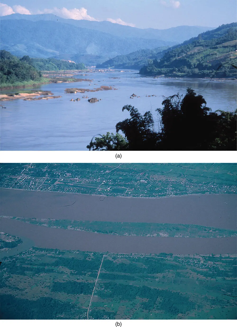
The great lengths of these rivers allow them to flow across a range of environments. The Mekong, for example, flows on both rock and alluvium, looking different ( Figure 1.2). The end part of the river needs to adjust to all such environmental variations plus the Quaternary changes in sea level.
Fluvial geomorphology generally is based on small and logistically manageable streams. A study of large rivers is necessary, although difficult, for multiple reasons. Large rivers form and modify subcontinental-scale landforms and geomorphological processes. A high number of them convey and discharge a large volume of water and sediment to the coastal seas. An understanding of modern large rivers helps us to explain past sedimentary deposits. Large rivers, such as the Amazon (Mertes and Dunne 2007), and their deposits may reveal basinal and regional tectonics, past and present climate, and sea-level fluctuations. Management of the water resources of a large river is often an essential step toward the supply of water and power to a large number of people. We need to study large rivers for many such reasons.

Figure 1.1 A sketch map showing the location of 24 large rivers in the world: 1, Amazon; 2, Congo; 3, Orinoco; 4, Ganga-Brahmaputra; 5, Changjiang; 6, Yenisei; 7, Mississippi; 8, Lena; 9, Mekong; 10, Parana-Uruguay; 11, St. Lawrence; 12, Irrawaddy; 13, Ob; 14, Amur; 15, Mackenzie; 16, Zhujiang; 17, Salween; 18, Columbia; 19, Indus; 20, Magdalena; 21, Zambezi; 22, Danube; 23, Yukon; 24, Niger.
1.2 A Book on Large Rivers
A number of individual large rivers have been studied and such studies published discretely. A collection of advanced essays on the general characteristics of large rivers, their selected case studies, and their utilisation and management is also available (Gupta 2007). In comparison, this volume is primarily an integrated textbook on large rivers and introduces the reader to the morphology and management of these huge conduits on which both the general physiography of the basins and utilisation of the resources of the rivers depend.
The discussion on large rivers starts with an account of their geological framework ( Chapter 2) that determines where they can be located and also what their physical characteristics would be. The geological framework of a large river is based primarily on large-scale tectonics commonly driven by plate movements. An uplifted zone and the adjoining subcontinental-scale water catchment area are necessary requirements for a big river. Smaller tectonic movements may further modify the basin and the channel and explain their detailed morphological characteristics.

Figure 1.2 The Mekong. (a) On rock, downstream of Chiang Saen, northern Thailand. (b) On alluvium near Savanakhet, Lao PDR, photographed from the air. Note the difference in form and behaviour between the two reaches. Large rivers commonly are a combination of a number of similar variations.
Source: A. Gupta.
The regional geology should create a drainage basin large enough to accumulate enough precipitation to support and maintain the big river. Chapter 3discusses the nature of water and sediment in a large river. The discharge in a large river is determined by various climatic criteria depending on its location: annual rainfall, seasonality in rainfall, and high episodic rain from synoptic disturbances such as tropical cyclones. The supply of water to large rivers could be from almost all parts of the watershed but the sediment supply generally is associated selectively with high mountains. For example, the discharge of the Orinoco is collected from most of the basin, irrespective of geology or relief, but its sediment supply is only from the Andes Mountains and the alluvial Llanos plains formed near the Andean foothills. In certain cases, several large rivers flow through arid landscapes without identifiable addition to their discharge but manage to sustain their flow because of the high discharge arriving from the upper non-arid parts of their drainage basins. Sediment in flood moves in large rivers both in downstream and lateral directions if large floodplains are present. The sediment grains travel a long distance to reach the sea and, in the process, become mature and sorted.
Читать дальше


