Avijit Gupta - Introducing Large Rivers
Здесь есть возможность читать онлайн «Avijit Gupta - Introducing Large Rivers» — ознакомительный отрывок электронной книги совершенно бесплатно, а после прочтения отрывка купить полную версию. В некоторых случаях можно слушать аудио, скачать через торрент в формате fb2 и присутствует краткое содержание. Жанр: unrecognised, на английском языке. Описание произведения, (предисловие) а так же отзывы посетителей доступны на портале библиотеки ЛибКат.
- Название:Introducing Large Rivers
- Автор:
- Жанр:
- Год:неизвестен
- ISBN:нет данных
- Рейтинг книги:5 / 5. Голосов: 1
-
Избранное:Добавить в избранное
- Отзывы:
-
Ваша оценка:
Introducing Large Rivers: краткое содержание, описание и аннотация
Предлагаем к чтению аннотацию, описание, краткое содержание или предисловие (зависит от того, что написал сам автор книги «Introducing Large Rivers»). Если вы не нашли необходимую информацию о книге — напишите в комментариях, мы постараемся отыскать её.
Introducing Large Rivers Introducing Large Rivers
Introducing Large Rivers — читать онлайн ознакомительный отрывок
Ниже представлен текст книги, разбитый по страницам. Система сохранения места последней прочитанной страницы, позволяет с удобством читать онлайн бесплатно книгу «Introducing Large Rivers», без необходимости каждый раз заново искать на чём Вы остановились. Поставьте закладку, и сможете в любой момент перейти на страницу, на которой закончили чтение.
Интервал:
Закладка:
The regional pattern of the channel of the Amazon depends on its changing discharge, sediment, and slope. Steep channels in bedrock and gravel characterise the valleys in the mountains. In the downwarped foreland zone with high sedimentation, rivers begin to build bars and shift smaller channels. Low-gradient meandering channels in fine material characterise the central trough of the Amazon. The channel and floodplain of the Amazon are incised into the central low trough of the basin displaying a complex pattern of channels of various size, scroll bars and levees, and lakes. Towards the east, tributaries are dammed by alluvium of the trunk river, forming characteristic river-mouth lakes. The gradient of the lower river being very gentle, tidal effects extend about 1000 km up the Amazon to Óbidos.
Beyond the Andes foreland, the floodplain of the Holocene Amazon lies below a landscape of low hills under thick forest cover. The forest is interspersed with savanna, and recent deforestation is visible towards the northern and eastern margin of the basin. The channel and the floodplain continue between discontinuous terraces which are about 5–15 m above the general flood surface. The Holocene sediment in the channel and the floodplain consists of medium sand and finer sediment, weathered to clay minerals and enriched quartz grains (Johnsson and Meade 1990).
The river tends to undercut the cohesive terrace above the floodplain at channel bends. Avulsions related to flow switching are common. A dense network of channels cut across the floodplain. Some of these channels are as big as the large tributaries, and floodplain channels about 100 m wide are seen everywhere. The Amazon, its anabranches, and floodplain channels, all shift. As a result, numerous scroll bars and depressions mark the surface of the floodplain. Mertes and Dunne (2007) summarised the Amazon as an entrenched river that is confined to its valley, remains straight, and is relatively immobile over hundreds of kilometres. Large-scale channel migrations or avulsions are common. This huge low-gradient river flows through a 40–50 km wide floodplain decorated with considerable complexity of anabranches, levees, and scroll bars. A complex mosaic of lakes, lake deposits and overbank sedimentation is commonly found on the wide floodplain. The smaller lakes could be due to small low-sediment tributaries being blocked by rapid floodplain alluviation of the Amazon. The lakes increase in size downstream ( Figure 3.4).
This general description of the morphology of the Amazon may vary in places. Although the Amazon flows on top of thick sedimentary layers along its central axis, it is still influenced by buried transverse structures ( Figure 2.2). Four major structural arches (Iquitos, Jutai, Purús and Gurupa) and the Monte Alegro Intrusion, occur underneath the sedimentary layers and modify the river near their location. The Amazon crosses the structural highs on a straightened course. The water surface steepens slightly, the floodplain narrows, the river tends to hug the foot of the terraces, scroll bars are found only at channel margins, and channel migration becomes less common. Gravity measurements for the Lower Amazon area show a change in the direction of the river and its form with gravity anomalies (Nunn and Aires 1988), indicating that the Amazon crosses its floodplain only in specific places. Structure controls even the biggest river in the world.
Many examples of tectonic control are found In the Amazon and its tributaries. For example, Franzinelli and Igreja (2002) associated the alignment of the lower Negro River (which joins the Amazon at Manaus) with a NW-SE tectonic lineament. Sunken crustal blocks and depressions have been created by intersecting a set of blocks along a half graben that is inundated to the depth of 20 m across a 20 km reach of the river. The Negro carries very little sediment and this small amount is flushed through the fault-lined depression with accumulation of only little sand bodies along river borders. The banks of the Negro are in cohesive cliffs of lacustrine deposits, and bedrock is exposed in river channels because of a shortage of sediment for cover (Franzinelli and Igreja 2002). Straight reaches of the middle Amazon have been related to recent activities along a set of NW-SE and SW-NE fractures (Latrubesse and Franzinelli 2002). These fractures were originally described in 1952 by Sternberg and Russell from river and lake alignments (Mertes and Dunne 2007). Latrubesse and Franzineli (2002) also interpreted the confluences of the Amazon as tectonically controlled, coinciding with a wide V-shaped sunken block ( Figure 4.6).
An impressive amount of sediment is deposited on the lowermost Amazonian floodplains, and in the floodplain lakes (Meade 2007). An average annual sediment discharge of 1240 (±130) million tonnes at Óbidos has been computed from a number of measurements by Dunne et al. (1998). The arrival of the turbid sediment in the sea is clearly seen in a satellite image ( Figure 3.4). About half of the sediment that passes Óbidos has been estimated to settle on the sea bed of the Amazon mouth (Kuehl et al. 1986) but a considerable amount is carried by the North Brazil Current to the northwest along the coastline and transported longshore around the northern promontory of Cabo Norte to ultimately reach the outer coastline of the delta of the Orinoco. Such sediment has travelled about 1600 km after leaving the mouth of the Amazon (Meade 2007). It is an extraordinary travelogue.
Three factors interact through the late Cenozoic, and particularly the late Quaternary, to determine the form of the Amazon and its floodplain: basin tectonic setting, climate, and sea-level fluctuations (Mertes and Dunne 2007). These factors control erosion, sediment transport and deposition in the Amazon valley and determine the morphology of its channel and floodplain. The final product is a huge river, often nearly straight, influenced by geological structural features underneath, wider between such structural features with characteristic floodplain features, and a levee-bounded main lower channel that carries sediment to the sea, leaving lakes unfilled behind the embankments.
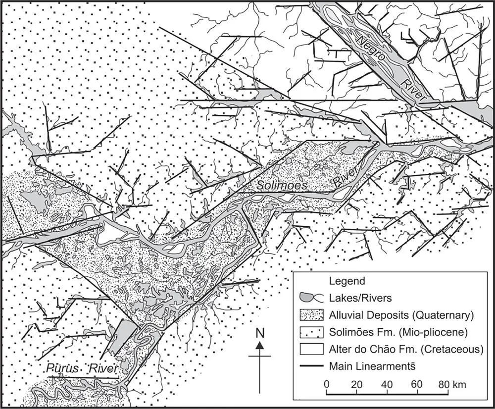
Figure 4.6 Structural control at the Amazon-Negro confluence. In Brazil the Amazon is known as the Solimoes.
Source: Adapted from Latrubesse and Franzinelli 2002.
4.4 The Ganga River
4.4.1 The Setting
Rising in the Himalaya, a convergent fold mountain range, the Ganga passes along a foredeep, joins with two other large rivers, the Brahmaputra and Meghna, and flows into the Bay of Bengal through the largest delta on Earth. The three rivers together drain over a million square kilometres, discharging the fourth highest water volume (970 × 10 km 3) and the second highest annual suspended sediment load (about 1000 million tonnes) to the sea. Such figures are reached because the river drains a high tectonic mountain range with intense monsoon rain falling over the catchment area. Unlike the Amazon, the Ganga has a long history of anthropogenic utilisation of the water of its channel and the land of its basin. The two major diversions of the Ganga happen via the upper Ganga Canal at Haridwar and Lower Ganga Canal at Narora. Part of its water is diverted down the Hugli distributary channel at the Farakka Barrage. The falling quality of the river water, transferring more and more polluted material, is probably the biggest concern in river management.
The Bhagirathi, the main headwater of the Ganga, rises at 3800 m from the Gangotri Glacier. The river is known as the Ganga from Devprayag where it is joined by the Alaknanda. After another 300 km of river distance, the Ganga descends to 290 MSL at Haridwar. Following the steep descent, the river flows parallel to the mountains along the extensive low-gradient alluvial plains of the Himalayan foreland, a subsiding continental interior setting.
Читать дальшеИнтервал:
Закладка:
Похожие книги на «Introducing Large Rivers»
Представляем Вашему вниманию похожие книги на «Introducing Large Rivers» списком для выбора. Мы отобрали схожую по названию и смыслу литературу в надежде предоставить читателям больше вариантов отыскать новые, интересные, ещё непрочитанные произведения.


Обсуждение, отзывы о книге «Introducing Large Rivers» и просто собственные мнения читателей. Оставьте ваши комментарии, напишите, что Вы думаете о произведении, его смысле или главных героях. Укажите что конкретно понравилось, а что нет, и почему Вы так считаете.