J. M. Boyd - The Hebrides
Здесь есть возможность читать онлайн «J. M. Boyd - The Hebrides» — ознакомительный отрывок электронной книги совершенно бесплатно, а после прочтения отрывка купить полную версию. В некоторых случаях можно слушать аудио, скачать через торрент в формате fb2 и присутствует краткое содержание. Жанр: unrecognised, на английском языке. Описание произведения, (предисловие) а так же отзывы посетителей доступны на портале библиотеки ЛибКат.
- Название:The Hebrides
- Автор:
- Жанр:
- Год:неизвестен
- ISBN:нет данных
- Рейтинг книги:5 / 5. Голосов: 1
-
Избранное:Добавить в избранное
- Отзывы:
-
Ваша оценка:
The Hebrides: краткое содержание, описание и аннотация
Предлагаем к чтению аннотацию, описание, краткое содержание или предисловие (зависит от того, что написал сам автор книги «The Hebrides»). Если вы не нашли необходимую информацию о книге — напишите в комментариях, мы постараемся отыскать её.
The Hebrides — читать онлайн ознакомительный отрывок
Ниже представлен текст книги, разбитый по страницам. Система сохранения места последней прочитанной страницы, позволяет с удобством читать онлайн бесплатно книгу «The Hebrides», без необходимости каждый раз заново искать на чём Вы остановились. Поставьте закладку, и сможете в любой момент перейти на страницу, на которой закончили чтение.
Интервал:
Закладка:
It is impossible to say whether or not the well-separated Mesozoic rocks on the various islands are the surviving parts of one continuous basin, or of separate basins, though the lateral continuity of the Great Estuarine rocks from Muck in the south through Eigg, Strathaird, and Raasay to Duntulm on the north point of Skye, is highly sustained. The most complete succession from the Triassic up through the Lower, Middle and Upper Jurassic to the Cretaceous occurs in Raasay and Trotternish ( Fig. 6).
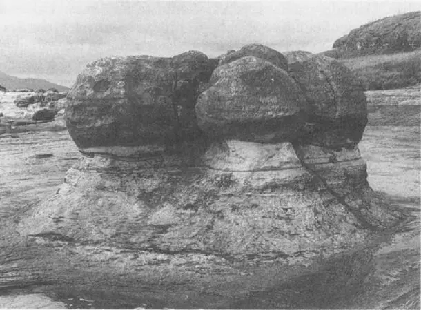
Calcareous concretions like cannon balls exposed by marine erosion of the Jurassic sandstones at Bay of Laig, Eigg (Photo British Geological Survey)
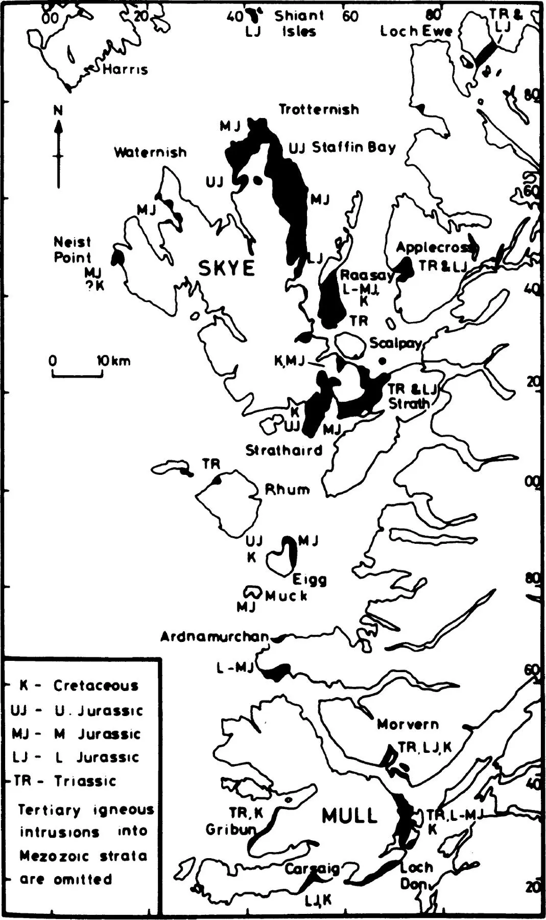
Fig. 6 Map showing the distribution of the Mesozoic rocks in the Hebrides (Hudson 1983)
The Triassic rocks are mainly sandstone and conglomerates derived from riverine and lake-bed deposits—fossil soils indicate periodic inundations in a semi-arid climate. The Jurassic rocks are by far the most extensive of the Mesozoic series above sea level. They are mostly sandstones, shales and limestones in that order of importance. However, the sandstones and shales often contain carbonate concretions which are eroded out like great cannonballs from the softer sandstone. The beds are generally fossil-bearing allowing precise correlation between strata at different sites using ammonites. The lower levels are marine and fine-grained, the middle is riverine, estuarine and deltaic in character, and the upper is again marine and fine-grained. These are the finest fossil beds in the Hebrides, and have attracted geologists since Hugh Miller so graphically described his collecting foray in Eigg and Skye in The Cruise of the Betsey (1858) (See here). Fossil sharks’ teeth and the bones of Pleisosauri and crocodiles have been found on Eigg; there are specimens of these and other Hebridean fossils in the Royal Museum of Scotland in Edinburgh. Lagoon beds were covered with mussels ( Praemytilus ) and other indicator species include brachiopods, oysters, and ostracods. Ammonites and belemnites abound in the shales and sandstones of Skye and Raasay. The Mesozoic series is capped locally with thin beds of upper Cretaceous sandstone in Skye, Raasay, Scaplay, Soay and Eigg. These have a maximum thickness of 25m but are usually less than 10m. They represent deposits in a shallow sea during a short interlude of erosion between the end of the Jurassic and the onset of the Tertiary volcanic epoch, when the Mesozoic rocks were buried under several hundred metres of lava and ash beds and cut by sills and dykes. A summary account of the Mesozoic in the Hebrides has been given by Hudson (1983), and the Jurassic and Cretaceous sediments in Scotland is reviewed by Hallam (1983).
Tertiary Rocks
During the Eocene commencing 60–65 million years ago, Europe and Greenland began moving apart. This crustal movement created the wide rift now filled by the North Atlantic, and was accompanied by much volcanic activity along the line of parting, from the south of England through Wales, Ireland, western Scotland, the Faeroes, and Iceland to Greenland. The whole segment of the earth’s crust is known as the North Atlantic or Thulean Igneous Province, of which the Hebridean Province, stretching from Ailsa Craig to St Kilda, is a part. The main centres of volcanic activity were in Arran, Mull, Ardnamurchan, Rum, Skye, St Kilda, and the submarine Blackstones Bank, all of which hold the magma chambers of large volcanoes (See here). Most of these and other islands—Treshnish, Staffa, Muck, Eigg, Canna and the Shiants—contain fragments of the laval flows and ash falls from these Eocene volcanoes. The sources of these outpourings are uncertain. One view is that they emanated from the above centres; another is that they issued from long fissures in the earth’s crust above, and stretching away from, the centres, much as occurs in the ‘shield’ volcanoes of Iceland today. The country rocks of many islands are also intruded by dykes and sills. These trend south-east to north-west and consist of both basalt and its coarser-grained relative, dolerite (See here). C.H. Emeleus (1983) has reviewed the geology of the Tertiary in Scotland and C.H. Donaldson (1983) has provided a useful summary account of the Tertiary in the Hebrides.
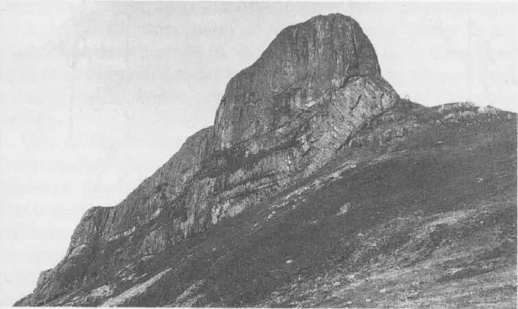
The Sgurr of Eigg (387m) is a pile of Tertiary rocks. A layer of pitchstone on the summit ridge lies unconformably on basalt lavas (Photo British Geological Survey)
There are two distinct types of igneous rocks—the fine-grained which have cooled quickly on or close to the earth’s surface, and the coarse-grained which have cooled slowly at depth in the crust. Basalts, rhyolites and pitchstones are of the former; gabbros, dolerites and granites are of the latter. In the main centres, i.e. the magma chambers of the great volcanoes, granites and gabbros predominate. The granites are rich in silica and feldspar and are grey or pink; the gabbros are dark, rich in iron, magnesium and calcium and poor in silica. Of the fine-grained volcanic rocks, basalt is by far the most important. It is a dark, fine-to-medium-grained analogue of the gabbro. Basalt is the stuff of the plateau lavas of north Skye and west Mull, and the terraced tablelands and columnar scarps of Durinish (Macleod’s Tables), Canna, Rum (Bloodstone), Eigg, Muck, Treshnish Isles, Staffa (Fingal’s Cave), and The Burg (MacCulloch’s Tree) in Mull. The Sgurr of Eigg is a layer of pitchstone overlying a conglomerate-filled valley in the basalt flows. The rock called Heisgeir off Canna has a hexagonal pitchstone pavement—a miniature Giant’s Causeway (See here). Probably basalt of over a kilometre thick was extruded over the crustal area now occupied by the Inner Hebrides. Much of this has since been removed by erosion, but the thickness of the existing basalt plateau reaches 1800m in central Mull and 600m in Skye and the Small Isles. The maximum thickness of individual flows is about 30m with the average about 8m, and the most extensive known flow stretches over 22km. An impression of the depth and extent of the Hebridean lava plateau in the late Tertiary (15 million years ago) can be obtained today in the Faeroe Islands, where a magnificent basalt plateau persists throughout most of the archipelago.
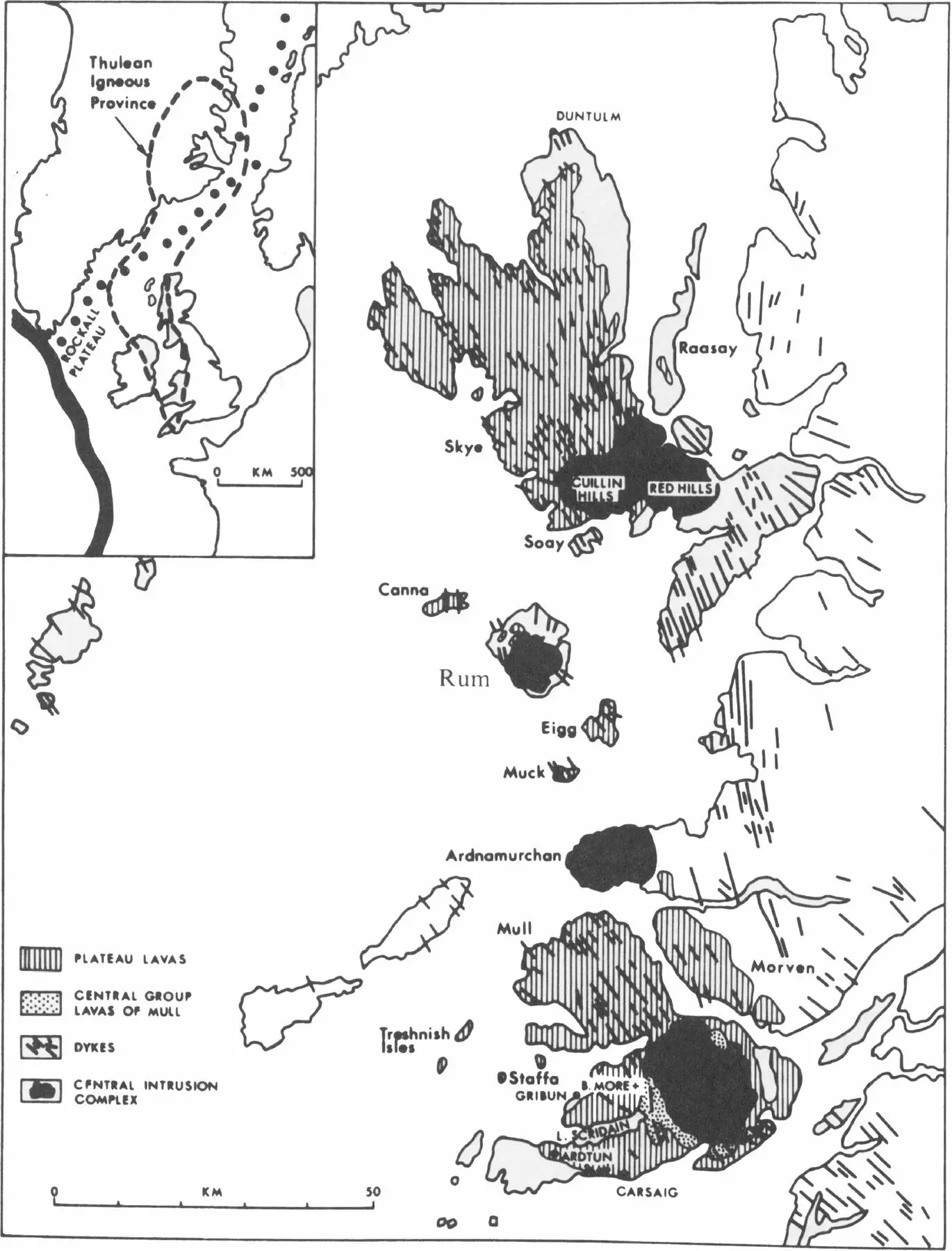
Fig. 7 Map showing the Tertiary volcanic centres and swarms of dykes in the Hebrides (Donaldson 1983)
One of the salient features of the main Tertiary centres, particularly well-displayed in central Mull, is the formation of calderas caused by crustal ring fractures. Within these fractures—which were superimposed upon each other over millions of years—the solid rock sank, and the space was filled by upwelling magma. This has caused the fairly sharp juxtaposition of great masses of granite many cubic kilometres in extent with even greater masses of gabbro. The plane of fracture is a shatter zone in which fragments of the dark gabbro became embedded in the upwelling granite, or vice-versa, to create a breccia. This is well seen in the sheer cliff of Mullach Mor at St Kilda, where the eucrite (gabbro) to the west marches with the granophyre to the east, and is deeply veined by it. (A more detailed description of the magma-chambers of Rum and St Kilda is given in Chapters 15and 16, respectively.)
Читать дальшеИнтервал:
Закладка:
Похожие книги на «The Hebrides»
Представляем Вашему вниманию похожие книги на «The Hebrides» списком для выбора. Мы отобрали схожую по названию и смыслу литературу в надежде предоставить читателям больше вариантов отыскать новые, интересные, ещё непрочитанные произведения.


Обсуждение, отзывы о книге «The Hebrides» и просто собственные мнения читателей. Оставьте ваши комментарии, напишите, что Вы думаете о произведении, его смысле или главных героях. Укажите что конкретно понравилось, а что нет, и почему Вы так считаете.