George Heritage - A Field Guide to British Rivers
Здесь есть возможность читать онлайн «George Heritage - A Field Guide to British Rivers» — ознакомительный отрывок электронной книги совершенно бесплатно, а после прочтения отрывка купить полную версию. В некоторых случаях можно слушать аудио, скачать через торрент в формате fb2 и присутствует краткое содержание. Жанр: unrecognised, на английском языке. Описание произведения, (предисловие) а так же отзывы посетителей доступны на портале библиотеки ЛибКат.
- Название:A Field Guide to British Rivers
- Автор:
- Жанр:
- Год:неизвестен
- ISBN:нет данных
- Рейтинг книги:3 / 5. Голосов: 1
-
Избранное:Добавить в избранное
- Отзывы:
-
Ваша оценка:
A Field Guide to British Rivers: краткое содержание, описание и аннотация
Предлагаем к чтению аннотацию, описание, краткое содержание или предисловие (зависит от того, что написал сам автор книги «A Field Guide to British Rivers»). Если вы не нашли необходимую информацию о книге — напишите в комментариях, мы постараемся отыскать её.
A Field Guide to British Rivers Written as a field guide to demonstrate practical examples of river types, and to highlight the pressures they experience and their often-parlous condition, this book is intended to better inform both river management approaches and the policy necessary to achieve this. Fundamentally, the authors seek to demonstrate how the hydrological, geomorphological, and ecological functions of rivers and their catchments are inexorably intertwined, and together how they generate and maintain rivers as dynamic entities.
A Field Guide to British Rivers — читать онлайн ознакомительный отрывок
Ниже представлен текст книги, разбитый по страницам. Система сохранения места последней прочитанной страницы, позволяет с удобством читать онлайн бесплатно книгу «A Field Guide to British Rivers», без необходимости каждый раз заново искать на чём Вы остановились. Поставьте закладку, и сможете в любой момент перейти на страницу, на которой закончили чтение.
Интервал:
Закладка:
This book aims to highlight the true form and function of watercourses and valley bottom areas using examples from the British Isles on which the authors have worked, either individually or together, over the last three decades. The intention is to encourage the reader to view fluvial systems, and their potential for management and restoration in a new light using examples of functional river types. The book will act as a guide to recognising these river types, and Chapter 2serves to illustrate and widen understanding of their classificationinto different functional types based on character and complexity. In Chapter 3, we illustrate the morphological unitmakeup of, and drivers and processes behind, each river type through a comprehensive photographic guide,and review the current research understanding of their form and function through a focussed review of published studies. Whilst we include examples of the science from outside the British Isles, these studies all focus on temperate rivers, and all examples of functional river types used are from the United Kingdom. Of great value to the river scientist is the ability to infer fluvial processes and probable directions of fluvial change from the current morphology of the system, and in Chapter 4, we provide a guide to “reading” rivers, describing key watercourse indicatorsthat help in this task. Finally in Chapter 5, we provide some thoughts regarding sensitive and appropriate management for British rivers going forward.

Figure 1.5 Semi‐natural multi‐channel network on the River Narr.
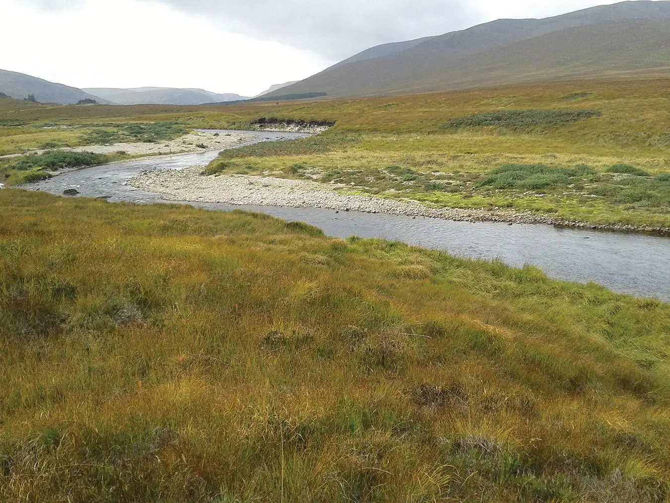
Figure 1.6 Laterally migrating active channel on the River Mallart, Syre, northern Scotland.
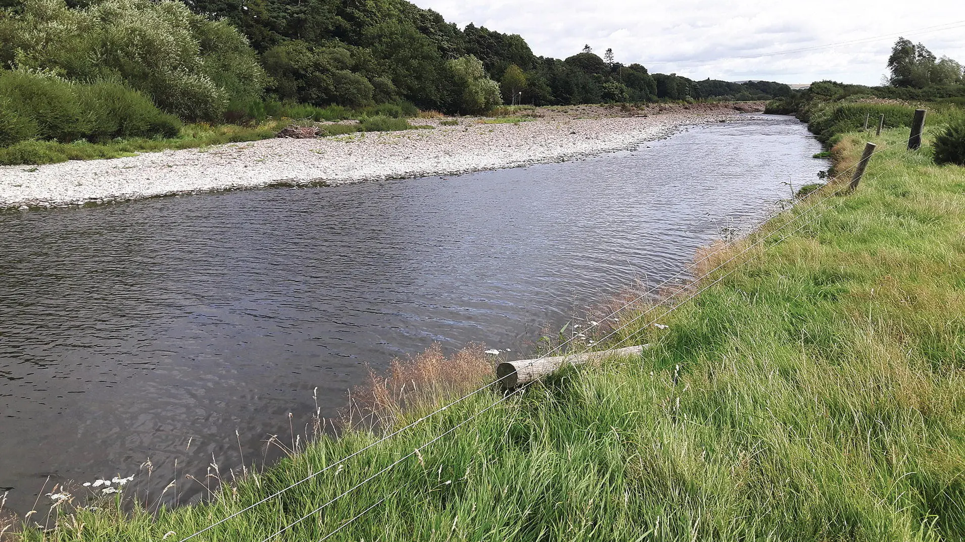
Figure 1.7 Active reach of the River Glen at Kirknewton, Northumberland, showing bank erosion and bar formation.

Figure 1.8 Wandering reach of the River South Esk, Scotland, showing sediment deposition and temporary storage.
2 River Types: A Brief Overview
2.1 Introduction
The pattern and features of any watercourse are influenced by the river type and its sediment load, as well as by the environment through which the stream flows (its catchment). Furthermore, the form of a channel both influences and reflects the processes active in the stream system. As such, the classification of channel form can help those concerned with rivers to understand the hydraulic and sediment processes acting on a watercourse and how the physical nature of the watercourse modifies local processes (Rosgen 1994). An appropriate river typology is thus a valuable tool when trying to understand and work with a watercourse and can facilitate interventions in rivers and across floodplains which work with current and restored processes to provide sustainable systems for the future. This short chapter reviews a wide variety of classifications developed for rivers.
2.2 Classification
River and floodplain systems exist on a continuum between bedrock and fully alluvial states resulting in a myriad of forms across the world. Many river classification systems have been developed to try to categorise watercourse types; initial attempts were primarily based on planform pattern. Straight, sinuous (often referred to as meandering), and braided patterns were distinguished by Leopold and Wolman (1957), and this typology was strongly linked to the slope‐discharge character identified at the same time by Lane (1957). This tripartite division for alluvial rivers has since been further developed, and Church and Rood (1983) provided an excellent précis of this research, extending to many other channel types. It was not until the early 1990s however, that the first combined river and floodplain classification was published (Nanson and Croke 1992) recognising the interlinked functionality of these two components of the wider system.
Despite these earlier research efforts, it often remains difficult to specifically categorise a watercourse. Rosgen (1994) noted this when matching observed characteristics to that anticipated from theory and how this poses significant problems when trying to understand and manage our river systems, while Kondolf and Downs (1996) have criticised regional classifications as providing little link to, or understanding of, river processes, river condition, or potential change trajectories.
Increasingly, the understanding of river and floodplain systems from a morphological perspective has facilitated development of hierarchical classification systems (e.g. Newson 1992; Montgomery and Buffington 1993; Sear 1994; Brierley 1999). In common these classifications impart heightened understanding of the interaction between the physical template of a system, dominant processes, and the ecosystems which develop as a result of these (Newson 1992; Maddock 1999). The knowledge that river form and process both interact and evolve simultaneously means that a functional classification system linked to channel morphology allows the user to predict behaviour from appearance, forecast the magnitude and directional nature of driving hydraulic and sediment controls, provide a frame of reference against which to judge degraded systems, and develop a common framework for understanding rivers.
2.3 Functional Classifications
As has already been noted, rivers display a diverse continuum of channel patterns and forms. This continuum results from complex processes of flow‐induced sediment erosion, transport, and deposition operating within the constraints imposed by the geology and terrain of the catchment landscape. River channel typologies provide a basis for ordering physical features and processes into groups based on common characteristics associated with these process controls. The Scottish Environmental Protection Agency’s (SEPA) 2012 morphological river typology ( Figure 2.1) is based on Montgomery and Buffington’s 1993 and 1997 typologies for montane streams in North America. This has been modified by SEPA to include lower gradient channels found in the United Kingdom. The typology is process‐based, i.e. channel sub‐types are grouped together according to the similar morphological processes present. As such, the channels in each of the groupings have similar sensitivity to external morphological pressures such as channel modifications. Other key features are that the types are considered “natural,” i.e. they assume the channel is unmodified and that types exist at a reach scale, with individual reaches varying considerably in length. This section briefly reviews the most common fluvial classification systems currently in use and for a variety of purposes.
2.3.1 Leopold and Wolman (1957)
Early work by Leopold and Wolman (1957) differentiated alluvial channel types based on the controlling variables of discharge and gradient ( Figure 2.2). Three classic channel types were recognised: meandering, wandering, and braided. The thresholds defining shifts between these channel types were observed to be mainly dependent on the calibre of the bed material present in the channel with braiding occurring at lower gradient/discharge values than gravel systems.
Читать дальшеИнтервал:
Закладка:
Похожие книги на «A Field Guide to British Rivers»
Представляем Вашему вниманию похожие книги на «A Field Guide to British Rivers» списком для выбора. Мы отобрали схожую по названию и смыслу литературу в надежде предоставить читателям больше вариантов отыскать новые, интересные, ещё непрочитанные произведения.


Обсуждение, отзывы о книге «A Field Guide to British Rivers» и просто собственные мнения читателей. Оставьте ваши комментарии, напишите, что Вы думаете о произведении, его смысле или главных героях. Укажите что конкретно понравилось, а что нет, и почему Вы так считаете.