George Heritage - A Field Guide to British Rivers
Здесь есть возможность читать онлайн «George Heritage - A Field Guide to British Rivers» — ознакомительный отрывок электронной книги совершенно бесплатно, а после прочтения отрывка купить полную версию. В некоторых случаях можно слушать аудио, скачать через торрент в формате fb2 и присутствует краткое содержание. Жанр: unrecognised, на английском языке. Описание произведения, (предисловие) а так же отзывы посетителей доступны на портале библиотеки ЛибКат.
- Название:A Field Guide to British Rivers
- Автор:
- Жанр:
- Год:неизвестен
- ISBN:нет данных
- Рейтинг книги:3 / 5. Голосов: 1
-
Избранное:Добавить в избранное
- Отзывы:
-
Ваша оценка:
A Field Guide to British Rivers: краткое содержание, описание и аннотация
Предлагаем к чтению аннотацию, описание, краткое содержание или предисловие (зависит от того, что написал сам автор книги «A Field Guide to British Rivers»). Если вы не нашли необходимую информацию о книге — напишите в комментариях, мы постараемся отыскать её.
A Field Guide to British Rivers Written as a field guide to demonstrate practical examples of river types, and to highlight the pressures they experience and their often-parlous condition, this book is intended to better inform both river management approaches and the policy necessary to achieve this. Fundamentally, the authors seek to demonstrate how the hydrological, geomorphological, and ecological functions of rivers and their catchments are inexorably intertwined, and together how they generate and maintain rivers as dynamic entities.
A Field Guide to British Rivers — читать онлайн ознакомительный отрывок
Ниже представлен текст книги, разбитый по страницам. Система сохранения места последней прочитанной страницы, позволяет с удобством читать онлайн бесплатно книгу «A Field Guide to British Rivers», без необходимости каждый раз заново искать на чём Вы остановились. Поставьте закладку, и сможете в любой момент перейти на страницу, на которой закончили чтение.
Интервал:
Закладка:
These statistics, although stark, should not come as a surprise. From a snap‐shot baseline sample of more than 5600 RHS reference sites across the United Kingdom and Isle of Man, Purseglove (1988) noted the following key points about the physical state of the 85 000 km of rivers and streams:
1 Very few pristine lowland channels flowing through semi‐natural landscapes remain;
2 Only 13.6% of lowland sites in England and Wales, 28% in Scotland, and 10.1% in Northern Ireland have an entirely unaltered channel;
3 3.7% of lowland sites in England and Wales, 1.7% in Scotland, and 5% in Northern Ireland can be classified as having severely modified channels;
4 Land drainage, flood defence, intensive agriculture, and urban development have significantly altered the channel shape and river landscape of many sites in the lowlands;
5 Extensive reinforcement and re‐sectioning of riverbanks, and channel impoundment can cause a significant reduction in habitat diversity;
6 Only 4.2% of sites below 50 m above sea level, with adjacent floodplain, have extensive wetlands, reflecting historical land drainage and current land‐use pressures affecting many river corridors.
Broad estimates are that some 80–90% of Europe’s river floodplains are now cultivated intensively compared to figures of 46% for North America (excluding northern Canada and Alaska) and 11% for African Rivers (Tockner and Stanford 2002). As such floodplain condition and functionality has been reported as being in a critical situation across Europe (Wenger et al. 1990; Klimo and Hager 2001). Tockner and Stanford (2002) note that in Europe and North America, up to 90% of floodplains are already “cultivated” and therefore functionally extinct; this figure is likely an underestimate for British rivers, given only 3.3% of the total river network of Britain is fully connected (Jones et al. 2019). The post‐war land drainage grants ceased in the 1980s, but the loss of wetland has continued to the present‐day and current attempts to improve watercourse form and function through restoration is having little or no measurable impact on floodplains.
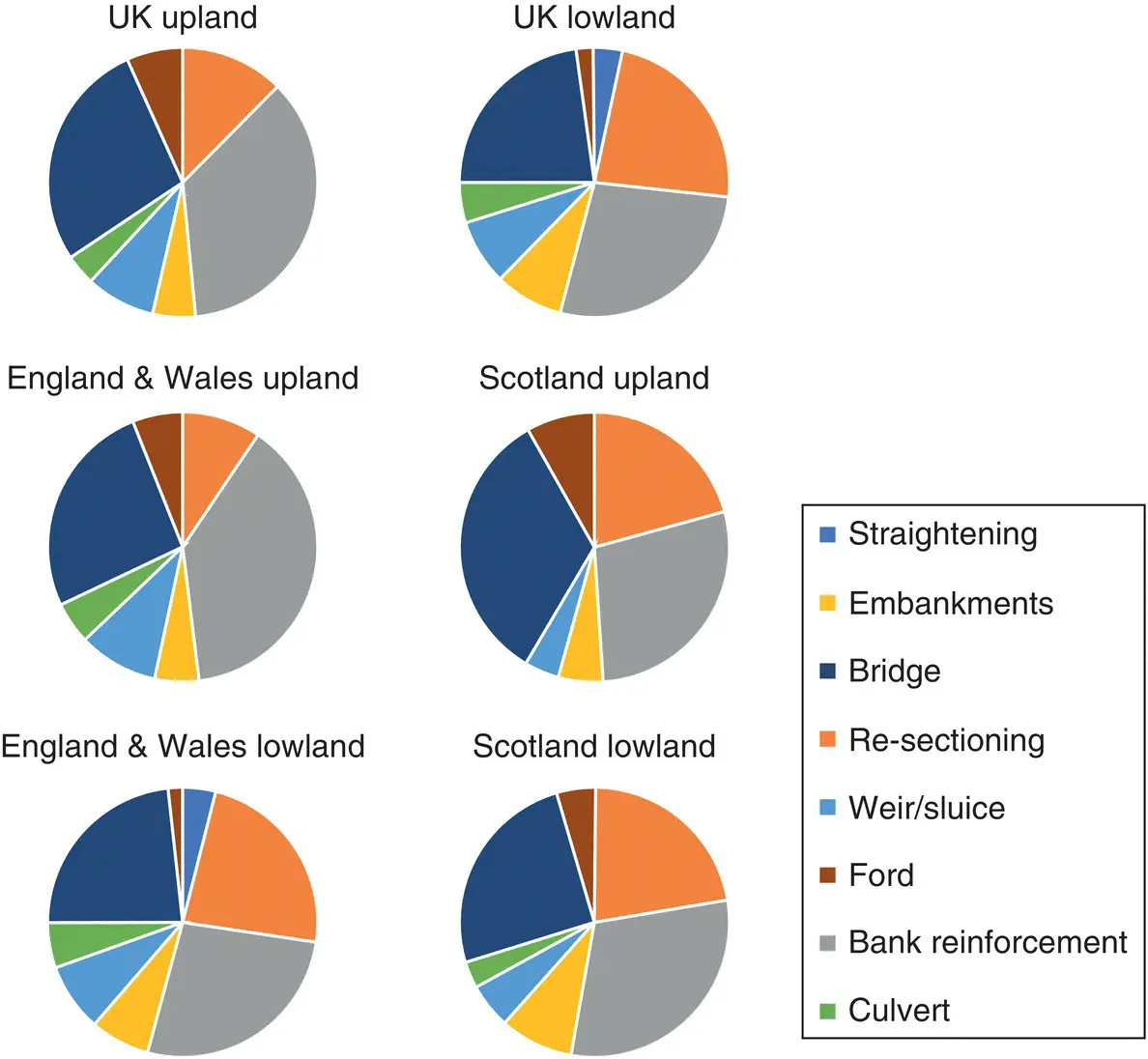
Figure 1.2 Cause of hydromorphic degradation in the UK.
Source: www.riverhabitatsurvey.org/wp-content/uploads/2012/07/RHS.pdf
It is interesting to review the figures above against the Water Framework Directive measure of river health currently being used across Europe. Entwistle et al. (2019a) used floodplain land‐use data for 2017 broken down according to current water body status generating 2975 auditable units. Water bodies presently at Good status were selected ( n = 375), arable and horticulture covers in excess of 50% of the floodplain area on around 15% of Good status water bodies, this increases to around 50% for area under improved grassland and when the two are considered together between 70 and 75% of Good Status water bodies are covered by at least 50% farmland. Around half of these water bodies are utilised over 90% by farming.
1.4 River and Floodplain Recovery
The preceding section summarises several studies relating to river and floodplain degradation; however, it remains difficult for the reader to understand exactly what has happened to watercourses and valley bottoms in England. Rivers seen in the landscape today are often regarded as “natural” systems with little regard to the actual levels of degradation they have suffered. This is perfectly understandable as we have grown up with heavily modified and managed systems, and we have few natural analogues left against which we can judge the degree of alteration. “Stability” is seen as desirable with neatness and uniformity favoured above natural functionality. Fortunately, this attitude is changing as the economics of river and floodplain management has resulted in reduced river training and a consequent increase in the influence of natural fluvial processes. Many systems are showing small but significant signs of recovery towards a better functioning system aligned with current catchment controls. Recovery has not always been back to a previous river state before human intervention as conditions in the catchment have changed significantly enough to cause a state change in our rivers, but their diversity is improving.
The situation above is best illustrated through examples. Figure 1.3illustrates a typical lowland watercourse; here historic engineering and current management has led to the development of a monotonous single‐thread watercourse devoid of in‐channel morphological units and showing no signs of any lateral movement due to revetment works and a subdued flood regime. Floodplain areas, although often extensive, display no functional morphological units with intensive land use severing hydrological and hydraulic connections, modifying, or destroying floodplain features and altering vegetative assemblages. Upland rivers have suffered similarly ( Figure 1.4). Natural flow paths have been altered to maximise valley bottom land use. Lateral activity has been suppressed through revetment and tree planting, in‐channel morphological development has been suppressed by repeat dredging and floodplain functionality has been disrupted due to a combination of bed lowering, embanking, and incision in response to human modification.
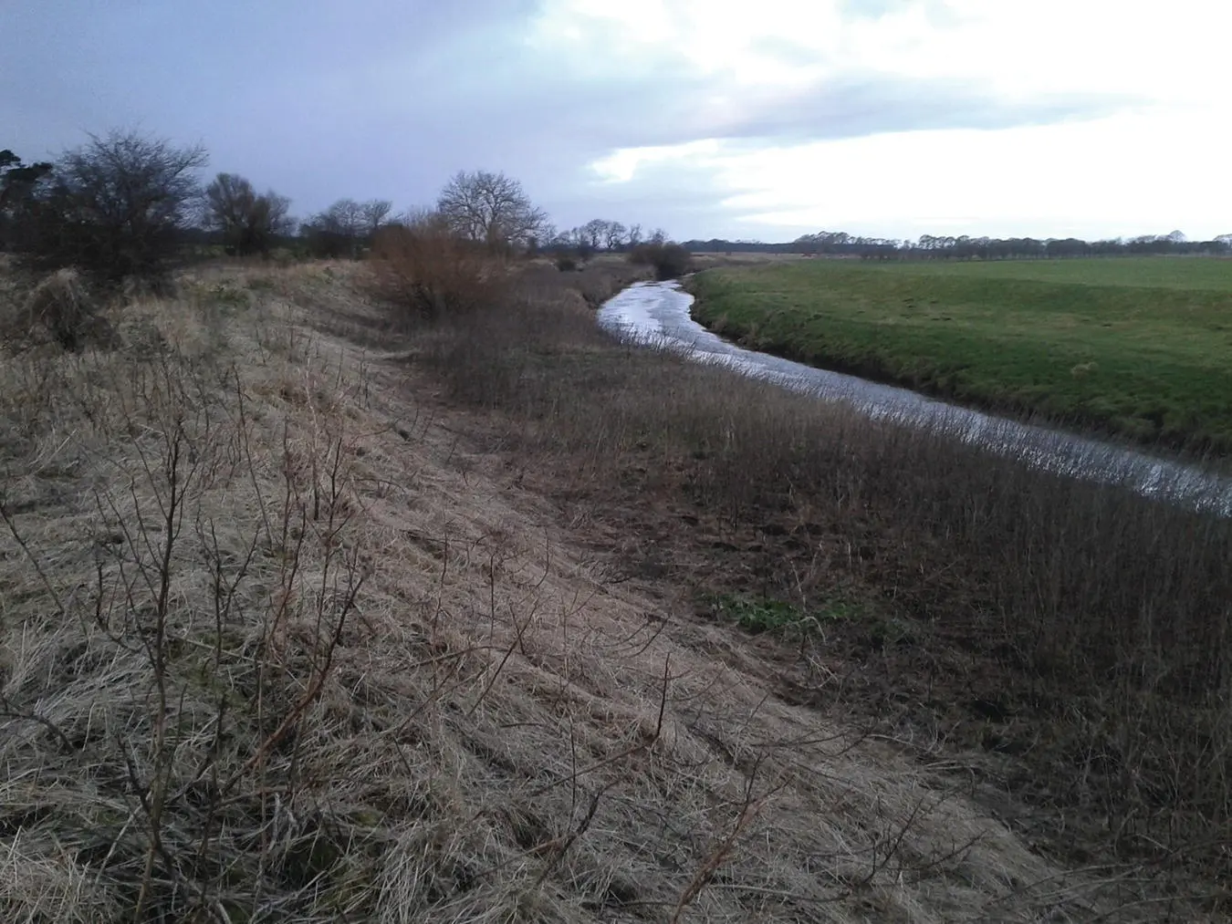
Figure 1.3 Typical heavily modified lowland system with artificial flood protection embankments, channel straightening and dredging, and removal of in‐channel and riparian vegetation. The Yorkshire Derwent at Yedingham.
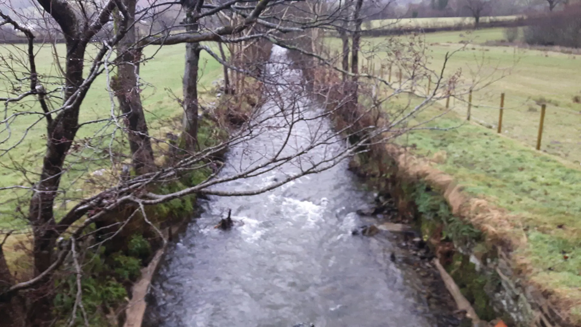
Figure 1.4 Typical heavily modified upland system, straightened, walled, and dredged. The Upper Whit Beck at Low Lorton.
Examples of naturally functioning fluvial systems are few and far between, existing only as small fragments developing because of a lack of system management. Nevertheless, these reaches offer valuable insights into how our rivers and floodplains would function when unconstrained, acting as exemplars against which we should be judging our present systems. On lowland rivers, the propensity appears to be one of the development of a low‐gradient stable multiple channel river network well connected to intervening areas of floodplain ( Figure 1.5). The recovery of such areas appears strongly influenced by vegetation which acts as the precursor to sediment deposition and consolidation and creates high levels of local morphologic, hydrologic, and hydraulic diversity. Development of such systems remains highly restricted, but their form and functionality, even at a local scale, offers clear indications of how many lowland systems should look and behave.
Upland systems appear to be naturalising most strongly through in‐channel feature re‐development leading to enhanced local bank erosion and lateral reworking of floodplain sediment, which on many rivers has created a well‐connected narrow inset floodplain ( Figure 1.6). On more energetic systems, the loss of constraints on channel movement has seen the development of strong active meandering systems ( Figure 1.7), or wandering channel networks ( Figure 1.8), both of which offer considerably higher morphologic, hydrologic, and hydraulic diversity over their previously managed state.
1.5 Purpose of This Book
Интервал:
Закладка:
Похожие книги на «A Field Guide to British Rivers»
Представляем Вашему вниманию похожие книги на «A Field Guide to British Rivers» списком для выбора. Мы отобрали схожую по названию и смыслу литературу в надежде предоставить читателям больше вариантов отыскать новые, интересные, ещё непрочитанные произведения.


Обсуждение, отзывы о книге «A Field Guide to British Rivers» и просто собственные мнения читателей. Оставьте ваши комментарии, напишите, что Вы думаете о произведении, его смысле или главных героях. Укажите что конкретно понравилось, а что нет, и почему Вы так считаете.