A Companion to the Hellenistic and Roman Near East
Здесь есть возможность читать онлайн «A Companion to the Hellenistic and Roman Near East» — ознакомительный отрывок электронной книги совершенно бесплатно, а после прочтения отрывка купить полную версию. В некоторых случаях можно слушать аудио, скачать через торрент в формате fb2 и присутствует краткое содержание. Жанр: unrecognised, на английском языке. Описание произведения, (предисловие) а так же отзывы посетителей доступны на портале библиотеки ЛибКат.

- Название:A Companion to the Hellenistic and Roman Near East
- Автор:
- Жанр:
- Год:неизвестен
- ISBN:нет данных
- Рейтинг книги:3 / 5. Голосов: 1
-
Избранное:Добавить в избранное
- Отзывы:
-
Ваша оценка:
A Companion to the Hellenistic and Roman Near East: краткое содержание, описание и аннотация
Предлагаем к чтению аннотацию, описание, краткое содержание или предисловие (зависит от того, что написал сам автор книги «A Companion to the Hellenistic and Roman Near East»). Если вы не нашли необходимую информацию о книге — напишите в комментариях, мы постараемся отыскать её.
A Companion to the Hellenistic and Roman Near East All contributors in this edited volume are leading scholars in their field, with a combination of established researchers and academics, and emerging voices. Contributors hail from countries across several continents, and work in various disciplines, including Ancient History, Archaeology, Art History, Epigraphy, Numismatics, and Oriental Studies.
In addition to furthering the integration of the Levantine lands in the classical periods into the teaching canon, the book offers readers:
The first comprehensively structured Companion and edited handbook on the Hellenistic and Roman Near East Extensive regional and sub-regional variety in the cross-disciplinary source material A way to compensate for the recent destruction of monuments in the region and the new generation of researchers’ inability to examine these historical stages in person An integration of the study of the Hellenistic and Roman Near East with traditional undergraduate teaching syllabi in the Anglo-Saxon world Perfect for undergraduate history and classics students studying the Near East,
will also earn a place in the libraries of graduate students and scholars working within Near Eastern studies, as well as interested members of the public with a passion for history.
A Companion to the Hellenistic and Roman Near East — читать онлайн ознакомительный отрывок
Ниже представлен текст книги, разбитый по страницам. Система сохранения места последней прочитанной страницы, позволяет с удобством читать онлайн бесплатно книгу «A Companion to the Hellenistic and Roman Near East», без необходимости каждый раз заново искать на чём Вы остановились. Поставьте закладку, и сможете в любой момент перейти на страницу, на которой закончили чтение.
Интервал:
Закладка:
The Peutinger Table conveys similar information as the itineraries but in visual form. It is a remarkable map of the Roman Empire drawn upon a scroll 22 feet (672 cm) long and no more than 13 inches (33 cm) high and composed of eleven parchment segments (Figure 3.1). The most recent study identifies the extant map as a late Carolingian (c. 1200) copy of a Diocletianic original (Talbert 2010: 83–84, 136). It depicts the roads and cities of the later Roman Empire, not in a geometrical projection akin to Eratosthenes’s or Ptolemy’s maps, but rather as a conception of the world with Rome at the center and Roman infrastructure highlighted, while land masses are compressed and stretched out of proportion. Segments 8 to 11 of the map depict the Near East: Palestine and Syria run along the bottom of segments 8 and 9, Antioch occupies a prominent position at the right side of segment 9, and Commagene and Mesopotamia run across segments 9 to 11. 11The Stadiasmus Maris Magni (Codex Matritensis 121) lists the harbors along the North Syrian coast, some of which appear on the Peutinger Table, including Balanea, Paltos, Gabala, Laodicia, Seleucia, and Alexandria ad Issum (Müller GGM I, 472–476, §§129–153).
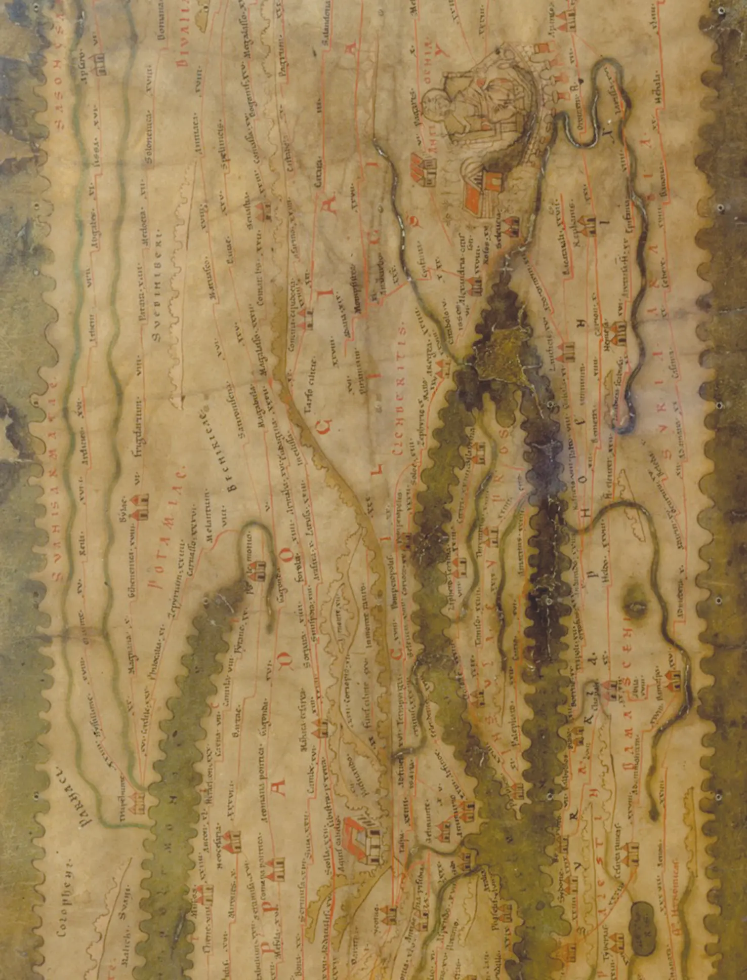
Figure 3.1 Near Eastern section from the Peutinger Table. Freely downloadable at https://www.cambridge.org/us/talbert/index.html, Map B, TP2000seg9 (detail).
The late-Roman itineraries show a significant continuity in the conception of geographia from the Hellenistic bematists, where the landscape of the Near East is made comprehensible by marking places and stations along a web of routes (cf. Parker 2001: 67; Salway 2001: 26). The Peutinger Table seems to fit in this mode, since it presents a thorough map of the same itineraries, yet its geographical form is baffling unless we understand how its original presentation was intended to impress upon viewers the centrality of Rome, the cohesion and civilized nature of the empire, and its Tetrarchic rulers’ detailed knowledge of their domains (Talbert 2010: 147–152). Its predecessor in purpose and form – if not cartographic projection – was Agrippa’s world map (Nicolet 1991: 102–103). Though we now have only later visualizations of Ptolemy’s Guide to Drawing the World , we do know that ancient geographers produced maps and debated for many centuries over how best to project the globe as a geometrical and political entity, the philosophical side to geography which is necessary to fully contextualize the sources for the Near East.
Philosophical Geographies
Writing geographia , like all intellectual pursuits in Greco-Roman antiquity, had its basis and its purpose in philosophy, and geographical theories and methods evolved in step with philosophical developments, as noted by Strabo at the outset of his work (1.1.1). This much was recognized in Agathemerus’s Survey of Geography (§§1–2), a brief historiography of pre-Ptolemean geography from Anaximander onwards. Early on, the Milesians mapped the earth in order to comprehend the nature of the cosmos and its motive forces, and their search for a reasonable governing order set the field for subsequent cartographic projections, arrangement of the continents, and studies of human inhabitants by region (Clarke 1999: 42–43). Later, the Peripatetics (see Shipley 2011: 17–18, 2012; Stevens 2016) under Aristotle and Theophrastus prioritized data collection and the summarization of what was and could be known about the world, emphasizing measurements, periploi , cataloging of peoples and places, and map-making, as evidenced by Theophrastus’s maps ( pinakes ) of places traversed by explorers (Diogenes Laertius 5.51: “the maps, in which are the circuits of the earth”). Scholars at Alexandria, such as Eratosthenes and Strabo, benefited from its repository of theoretical texts and pragmatic records. Taking a cue from their colleagues in literary criticism, they sought to establish comprehensive and authoritative geographies rooted in axiomatic wisdom, sometimes at the expense of observations of actual landscapes (Roseman 2005: 28–31, 39). Strabo (2.5.1) asserts that mathematical principles and astronomy are more reliable than on-the-ground observations of a landscape, citing a traveler on the Babylonian plain who when relying on local “notions” is ignorant of his true position on the earth, versus the geographer who is always oriented in space regardless of whatever the natives believe about his location. Ptolemy ( Geog . 1.1.5–6) took a more temperate position regarding visual representations, arguing that world cartography requires mathematical skill, but regional topography (or “chorography”) is best done by an artist ( graphikos anēr ).
Differing Methodologies
Even with cutting edge theory, geographical writers were still constrained by the empirical data, though Strabo and others severely criticized any sources whose methods and measurements were less than satisfactory. Their handling of material tended to treat geographia as a physical science or as part of historia , the enquiry into human experience in time, space, and culture (Clarke 1999: 28–29). Both approaches employed theory and logic as well as practical observation, whether theoretical physics and measurements or political principles and ethnography (Roseman 2005: 29–30). Most geographical writers used both approaches in turns. For example, Hecataeus’s Periodos gēs and Genealogiai (or Historiai ) were part of the same intellectual project and cover similar topics (Clarke 1999: 60–62), and Herodotus (4.36–40) used his research on the peoples of Asia to dispute earlier cartographers’ ideas of a circular earth divided evenly between Europe and Asia. Both Pseudo-Skylax and Agatharchides of Cnidus followed the Peripatetic school, and their Periploi combine distance measurement with sometimes oddly chosen but detailed topographic, ethnographic, botanic, or zoologic descriptions (Pseudo-Skylax: Shipley 2011: 77–81, 2012: 15–17; Agatharchides: Burstein 1989: 13; Strabo 14.2.15). Even Alexander’s bematists followed the prevailing intellectual trend and added to their measurements some local details to edify their Aristotelian-trained king.
Until the Latin texts of Pomponius Mela’s Chorographia (43 CE) and Pliny the Elder’s Natural History , Greek scholarship provided the only documentary geographies on the Near East (Mela: Romer 1998; Pliny: cf. Murphy 2004). Historians such as Livy supplied some information, but not as part of a larger geographical project. For most Romans knowledge of Near Eastern geography arrived in the form of triumphal paintings, images including allegorical personifications of conquered cities to topographies, cityscapes, and panoramas depicting notable features or historical narratives of the victorious generals’ expeditions (Nicolet 1991: 69; Holliday 1997: 137ff; Murphy 2004: 154ff). Livy (37.59.3–5) reports that Scipio Asiaticus paraded 134 representations of captured Asian towns ( oppidorum simulacra ) in his 188 BCE triumph, and in his triumph of 61 BCE Pompey is said to have had inscriptions listing conquered regions and cities from Pontus to Arabia, alongside images (possibly geographical), and a trophy of the entire oikoumenē or orbis terrarum (Plut. Pomp . 45.1–3; Appian Mith . 17.117; Dio 37.21.2). Even Ovid ( Ars Am . 1.213–228) recommended explaining the triumphal geographic paintings as an aid to flirtation, listing Mesopotamia, Armenia, and Persia, regions taken in Augustan campaigns, though the allegorical captive Persia was only ever anticipated of Gaius Caesar’s unrealized campaign (Nicolet 1991: 44). Agrippa’s world map was a grandiose version of the triumphal paintings, representing the world now conquered by Roman forces and the oikoumenē subjected to Roman imperium (cf. Holliday 1997: 137). He and his colleagues on the project mapped the world with a system similar to Eratosthenes’s sphragides (see below), using twenty-four regions each with length and width dimensions (Nicolet 1991: 101–102). 12
Читать дальшеИнтервал:
Закладка:
Похожие книги на «A Companion to the Hellenistic and Roman Near East»
Представляем Вашему вниманию похожие книги на «A Companion to the Hellenistic and Roman Near East» списком для выбора. Мы отобрали схожую по названию и смыслу литературу в надежде предоставить читателям больше вариантов отыскать новые, интересные, ещё непрочитанные произведения.


Обсуждение, отзывы о книге «A Companion to the Hellenistic and Roman Near East» и просто собственные мнения читателей. Оставьте ваши комментарии, напишите, что Вы думаете о произведении, его смысле или главных героях. Укажите что конкретно понравилось, а что нет, и почему Вы так считаете.