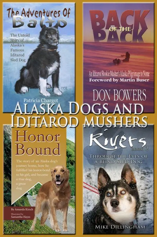
Mike Dillingham - Alaska Dogs and Iditarod Mushers - The Adventures of Balto, Back of the Pack, Honor Bound, Rivers
Здесь есть возможность читать онлайн «Mike Dillingham - Alaska Dogs and Iditarod Mushers - The Adventures of Balto, Back of the Pack, Honor Bound, Rivers» весь текст электронной книги совершенно бесплатно (целиком полную версию без сокращений). В некоторых случаях можно слушать аудио, скачать через торрент в формате fb2 и присутствует краткое содержание. Жанр: Природа и животные, на английском языке. Описание произведения, (предисловие) а так же отзывы посетителей доступны на портале библиотеки ЛибКат.
- Название:Alaska Dogs and Iditarod Mushers: The Adventures of Balto, Back of the Pack, Honor Bound, Rivers
- Автор:
- Жанр:
- Год:неизвестен
- ISBN:нет данных
- Рейтинг книги:3 / 5. Голосов: 1
-
Избранное:Добавить в избранное
- Отзывы:
-
Ваша оценка:
Alaska Dogs and Iditarod Mushers: The Adventures of Balto, Back of the Pack, Honor Bound, Rivers: краткое содержание, описание и аннотация
Предлагаем к чтению аннотацию, описание, краткое содержание или предисловие (зависит от того, что написал сам автор книги «Alaska Dogs and Iditarod Mushers: The Adventures of Balto, Back of the Pack, Honor Bound, Rivers»). Если вы не нашли необходимую информацию о книге — напишите в комментариях, мы постараемся отыскать её.
Back of the Pack: An Iditarod Rookie Musher’s Alaska Pilgrimage to Nome
Rivers: Through the Eyes of a Blind Dog
Honor Bound: The story of an Alaska dog’s journey home, how he fulfilled his honor-bond to his girl, and became a true dog, a great dog
Alaska Dogs and Iditarod Mushers: The Adventures of Balto, Back of the Pack, Honor Bound, Rivers — читать онлайн бесплатно полную книгу (весь текст) целиком
Ниже представлен текст книги, разбитый по страницам. Система сохранения места последней прочитанной страницы, позволяет с удобством читать онлайн бесплатно книгу «Alaska Dogs and Iditarod Mushers: The Adventures of Balto, Back of the Pack, Honor Bound, Rivers», без необходимости каждый раз заново искать на чём Вы остановились. Поставьте закладку, и сможете в любой момент перейти на страницу, на которой закончили чтение.
Интервал:
Закладка:
The moon finally rises after midnight but sheds no illumination on the endless country through which we are traveling. If anything, the moonlight distorts reality and further frustrates our efforts to orient ourselves. The trail is a faint line cutting through trees and across tundra, ever arrowing toward the northeast. At least the Big Dipper and the North Star are constant above me; everything else seems to be a strange, dimly lit dream.
At one point I crest a hill and see a string of faint lights strung out over the ridges ahead like ancient Druidic hilltop beacons. They are campfires and headlights of mushers who have stopped to rest for a few hours before resuming the trek. These few nights of the race are the only time this particular constellation will shine all year — actually two years, because the northern route is only used in even-numbered years.
Again the Tolkienesque images of mysterious fairy lights and murky wilderness and epic journeys flood my increasingly fatigued mind. I usually dust off Lord of the Rings every few years, but from now on it will always remind me of this voyage through a half-imagined landscape far removed from reality as I previously thought it existed.
Finally I stop the team and climb on to the sled bag for a nap. The temperature is surprisingly moderate but still I wake up shivering in an hour. This seems to be a practical natural alarm clock and many mushers use it. I rouse the dogs and we slowly pull on up the trail as the first hint of dawn outlines the low mountains to the east.
An hour or two later we cross a major stream I assume is the North Fork of the Innoko, which means we’re making measurable progress. I’m reasonably certain we’re within 20 miles of Sulatna Crossing and the Holy Grail of the hospitality tent and I decide to keep pushing until we get there.
After another uphill slog and a haul across upland woods and meadows, including a stretch where the trail perilously skirts the edge of a 50-foot cliff, we enter the old mining district. The main signs of human activity are huge piles of tailings from placer mining.
At one point we climb up to a snow-covered runway lined with shuttered buildings. I’ve seen this from the air; it dates to pre-World-War-II days but is still used occasionally in the summer. For now it’s completely deserted, with doors hanging forlornly open and abandoned 1940s-vintage trucks buried under snowdrifts.
Leaving the runway we climb up a ridge toward what’s left of Poorman. In the glory days of the Ruby mining district 80 years ago Poorman was a boom-town; this trail was a bustling thoroughfare for thousands of miners year-round. Now, a few old cabins lie half-hidden in the trees, all abandoned. No one has lived here for many years and my sleep-deprived mind can easily imagine the ghosts of departed miners lurking in the shadows.
We cross a number of old ditches used to drain diggings and channel water to the hydraulic nozzles which could wash a whole cliff into the sluices in a few days. Some gullies are 10 or 15 feet deep with near-vertical sides. To cross them the trail makes abrupt dives and climbs with little warning. In my less-than-alert state I spill the sled more than once.
The dogs are starting to show signs of fatigue but I don’t want to stop them until we get to the tent and can have a good, long rest. Eventually we start down the long grade to the Sulatna River and the decrepit steel bridge at Sulatna Crossing. Just before the bridge we pick up the 1920s-era mining road leading 50 miles north to Ruby and the Yukon River. Like the road to Ophir, part of it is state-maintained but only a few miles around Ruby are plowed in the winter.
We trundle up to the bridge and I see the old plank decking has long since rotted away; in its place is a four-foot-wide pathway of modern plywood laid across the rusted girders with a 20-foot drop to the river yawning below. More than a few teams would balk at this kind of obstacle, but Socks casually leads us on across without hesitation; he never ceases to amaze me.
On the other side of the river I start to look for the tent. I don’t see it in the immediate vicinity of the bridge, so I assume it’s a couple of miles further on where the old checkpoint used to be located. By this time I can’t wait to get the dogs fed and bedded down and have a good rest myself in the tent. I’m surprised when I don’t see anything at the old checkpoint site, but assume it’s got to be close.
We press on for another mile or two and then I see half a dozen teams parked along the trail ahead, obviously intending to camp out for the remainder of the day. Linda Joy walks over and says this is the hospitality tent, whether the tent is here or not. No one else knows where it is and nobody wants to go any farther up the road chasing what now seems to be a mirage. It’s getting hot and everyone has had a rugged trip up from Cripple. I can either stop here or thread my way past the bivouacked teams and continue what seems to be a wild goose chase for the elusive tent.
With a sigh I stop the team and prepare for a camp out. It’s late morning and the temperature must be pushing 40 in the warm sun. There’s no way I’m going to drive the dogs through the afternoon in this heat after what we’ve just survived. I chat with Lisa Moore and Linda Joy while I’m melting snow for the dogs’ lunch. We declare this an official meeting of the back-of-the-pack club and compare notes on the trail. We all admit to getting derailed in the Maze and have seen so much overflow we’re worried the dogs will grow webbed feet.
And we all agree we’re beat, mushers and teams alike; this has been a far tougher run up from Ophir and Cripple than we ever imagined. It’s been almost 30 hours since we left Ophir yesterday morning and the brief rest at Cripple didn’t do much good, nor did the quick naps along the trail.
Everyone plans to spend at least six hours here before pushing the last stretch to Ruby. It’s only 50 miles and it’s all on the old mining road, but it includes a lot of heavy-duty climbing as the right-of-way skips from valley to valley over 1,000-foot ridges. It will definitely be better this evening when the dogs can keep cool.
I busy myself feeding the dogs and checking feet, which are in surprisingly good shape considering the glacier’s worth of ice on the trail. After a lazy nap in the sun I wake up to find most of the other teams gone. It’s about four o’clock and the shadows are starting to lengthen. I get the dogs up and off the snow at the side of the trail where they’ve made their nests.
In the process Silvertip and Bear, who have run happily together for several hundred miles, get into a snapping match. I pull Silvertip away and Bear decides to get in his licks while he can. Unfortunately he misses and chomps my left hand, with which I’m trying to extract Silvertip.
I react instinctively by flailing my right arm for support, but I hit something very hard with an unintended full-force karate chop. I don’t know if I’ve smashed a nearby six-inch birch trunk or the sled, but I instantly know I’ve done something bad to my hand. Even Bear and Silvertip suddenly quiet down as they realize I’m no longer in a very playful mood.
Within minutes the area around my fifth metacarpal between the little finger and the wrist is starting to swell and turn an ugly yellow and brown. If it’s not broken, it’s a good imitation. I try to flex it and find I have no strength left for many movements I normally take for granted.
I stare at it and can’t believe I’ve done something this stupid: I’ve disabled my hand in the middle of a two-week ordeal in which I already don’t have enough hands. Worse, it’s my right hand, and I’m right-handed. And just for good measure the back of my left hand shows a perfect impression of the arc of Bear’s front teeth; there are several puncture wounds and more than a little blood but I can still move all my fingers so I don’t think he’s hit any tendons.
Читать дальшеИнтервал:
Закладка:
Похожие книги на «Alaska Dogs and Iditarod Mushers: The Adventures of Balto, Back of the Pack, Honor Bound, Rivers»
Представляем Вашему вниманию похожие книги на «Alaska Dogs and Iditarod Mushers: The Adventures of Balto, Back of the Pack, Honor Bound, Rivers» списком для выбора. Мы отобрали схожую по названию и смыслу литературу в надежде предоставить читателям больше вариантов отыскать новые, интересные, ещё непрочитанные произведения.


Обсуждение, отзывы о книге «Alaska Dogs and Iditarod Mushers: The Adventures of Balto, Back of the Pack, Honor Bound, Rivers» и просто собственные мнения читателей. Оставьте ваши комментарии, напишите, что Вы думаете о произведении, его смысле или главных героях. Укажите что конкретно понравилось, а что нет, и почему Вы так считаете.