Mike Dillingham - Alaska Dogs and Iditarod Mushers - The Adventures of Balto, Back of the Pack, Honor Bound, Rivers
Здесь есть возможность читать онлайн «Mike Dillingham - Alaska Dogs and Iditarod Mushers - The Adventures of Balto, Back of the Pack, Honor Bound, Rivers» весь текст электронной книги совершенно бесплатно (целиком полную версию без сокращений). В некоторых случаях можно слушать аудио, скачать через торрент в формате fb2 и присутствует краткое содержание. Жанр: Природа и животные, на английском языке. Описание произведения, (предисловие) а так же отзывы посетителей доступны на портале библиотеки ЛибКат.
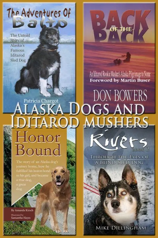
- Название:Alaska Dogs and Iditarod Mushers: The Adventures of Balto, Back of the Pack, Honor Bound, Rivers
- Автор:
- Жанр:
- Год:неизвестен
- ISBN:нет данных
- Рейтинг книги:3 / 5. Голосов: 1
-
Избранное:Добавить в избранное
- Отзывы:
-
Ваша оценка:
Alaska Dogs and Iditarod Mushers: The Adventures of Balto, Back of the Pack, Honor Bound, Rivers: краткое содержание, описание и аннотация
Предлагаем к чтению аннотацию, описание, краткое содержание или предисловие (зависит от того, что написал сам автор книги «Alaska Dogs and Iditarod Mushers: The Adventures of Balto, Back of the Pack, Honor Bound, Rivers»). Если вы не нашли необходимую информацию о книге — напишите в комментариях, мы постараемся отыскать её.
Back of the Pack: An Iditarod Rookie Musher’s Alaska Pilgrimage to Nome
Rivers: Through the Eyes of a Blind Dog
Honor Bound: The story of an Alaska dog’s journey home, how he fulfilled his honor-bond to his girl, and became a true dog, a great dog
Alaska Dogs and Iditarod Mushers: The Adventures of Balto, Back of the Pack, Honor Bound, Rivers — читать онлайн бесплатно полную книгу (весь текст) целиком
Ниже представлен текст книги, разбитый по страницам. Система сохранения места последней прочитанной страницы, позволяет с удобством читать онлайн бесплатно книгу «Alaska Dogs and Iditarod Mushers: The Adventures of Balto, Back of the Pack, Honor Bound, Rivers», без необходимости каждый раз заново искать на чём Вы остановились. Поставьте закладку, и сможете в любой момент перейти на страницу, на которой закончили чтение.
Интервал:
Закладка:
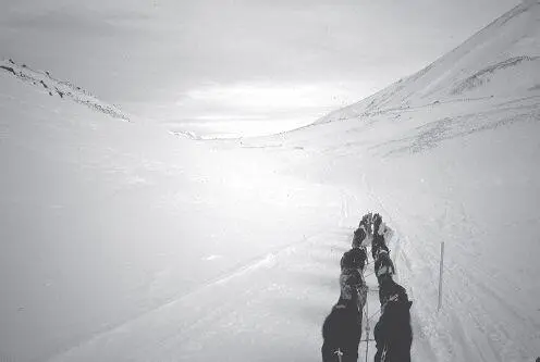
Today the scenery is magnificent in the rich afternoon light as we work our way toward the branch canyon leading to Rainy Pass. We’re in the heart of the Alaska Range; ridges on both sides tower to 6,000 feet or more. Fifteen miles to the north, and visible up every side valley, are the breathtaking granite pinnacles of the Cathedral Spires, their sheer rock walls rising as much as a mile above the glaciers at their feet. Mount McKinley — Denali — is more than 80 miles northeast, but its skyscraping 20,000-foot height lets us catch a glimpse or two of it and its 17,000-foot neighbor Mount Foraker despite the intervening terrain.
I’ve flown this route more times than I can count, at all altitudes and in all flavors of weather. I recognize the landmarks and know exactly where I am from a purely geographical standpoint, but being here on the ground is a totally different reality. There is something much more three-dimensional about surface travel, looking up at the mountains which lose much of their impact from the cockpit of an airplane. And the trail is far from the direct route afforded by a plane, varying from mile to mile and even step to step in a way the pilot can never experience.
The barren, often windswept summit of Rainy Pass in the Alaska Range is more than 3,000 feet above sea level, the highest point on the race.
As the shadows of the ridges creep over the valley through which we are running, the dogs pull steadily up into the pass. After we leave the open tundra, we follow a stream bed for a few miles, and then skirt a small lake. Parts of the trail are over open rocks the size of bowling balls; there may have been snow covering them for earlier mushers, but there’s nothing now but raw stone.
Finally we shoot straight up a forbidding slope. After 15 steep minutes, most of which sees me walking beside the sled or even pushing it, we crest the pass. I can’t help but be reminded of our crowning climb in the Copper Basin last year. Now as then, I stop the team for a brief rest and a survey of our hard-won domain.
It’s just past sunset. To the west, the series of rugged ridges descending to the broad Kuskokwim Valley is suffused with luminous golden backlight from the just-vanished sun. The mountaintops on either side and behind me are a radiant violet in the alpenglow. The full moon is already up in the east, a robust globe of weathered ivory hovering over the snow-mantled peaks.
There is no wind, and the absolute silence is broken only by the quiet breathing of the dogs. We are the only living creatures in this elemental universe of light and sky and snow and rock and shadow. In a journey laden with too many hours of work, pain, anxiety, and discouragement, this is one of the treasured rewards, one of the jewels beyond price which makes distance mushing in general, and the Iditarod in particular, worth all the sweat and worry.
However, it’s all downhill from here, and that means my Light Brigade must now charge into the Valley of Death, culminating in the Dalzell Gorge. With some trepidation I give Socks the okay and we plummet down the open snowfield toward the Pass Fork valley, which will join Dalzell Creek in a couple of miles. After that, it’s only a few miles through the Gorge, then five easy miles to the haven of the checkpoint cabin at Rohn.
Enough light remains for me to get the lay of the land as we careen into the narrowing valley and cross the timberline (in this case, more properly the brush line). This proves fortuitous because the steeply descending trail down Pass Fork turns out to be a nasty piece of work.
There isn’t enough snow for my brake to be really effective and all I can do is dig it in hard when we’re crossing a patch of crusty snow or even bare dirt. The trail twists and turns through narrow rocky ravines and across half-collapsed ice bridges over Pass Fork itself, mercifully only a few inches deep in most places. At one point an avalanche has partially blocked the canyon; the trail plows directly up and across the jumble of hardened snow and rocks.
In the deepening dusk I’m worried I’ll miss something and wreck. The dogs are full of energy and charge on as I brake and swerve and lean behind them. Despite the cool temperatures and downhill run I’m soaked in sweat from manhandling the sled. We bang more than a few rocks and sideswipe more trailside willow bushes than I can count.
Eventually the trail begins to level out as we merge with the main valley of Dalzell Creek. The gorge is still a few miles ahead and we’ve got some fairly straight and level running between here and there. At one point the marked trail makes an abrupt detour for no apparent reason. By the time we bounce up and over a bank and through the hinterland and rejoin the beaten path, I’m convinced the trailbreakers were imbibing something stronger than coffee.
Not too much farther on, the trail makes another excursion 100 feet or more directly up the south wall of the valley. We then run along a wooded, ever-narrowing bench hung on the side of the mountain for a half-mile until I see another of the now-infamous yellow warning signs: “Dangerous Trail Conditions Ahead.” This is the Dalzell Gorge.
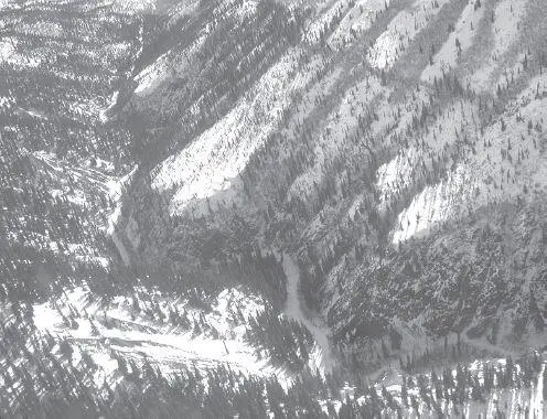
The Dalzell Gorge is one of the most infamous stretches on the entire Iditarod. The original trail high on the slope above the canyon is unusable, and the race now runs through the very bottom of the gorge. There is always open water and treacherous ice and more than a few mushers come to grief here every year.
Based on advice from race veterans, I stop the team at the top of the precipice and disconnect four tuglines in the rear of the team. I don’t want too much power for the maze we’re about to enter. After all, it’s mostly downhill and excess energy can only be dissipated in unhealthy ways, of which the Gorge provides more than enough.
With a deep breath and a transfusion of Tums, I give Socks an “Easy, easy, easy!” which he interprets as a green light for the Indianapolis 500. Thankful I’ve disabled at least four cylinders of my supercharged motor, I hang on for dear life as we surge into the abyss.
The grand entrance to the Gorge is a plummeting descent of 200 feet that seems like 1,000. It takes every bit of my strength to keep the brake stomped into the churned-up trail. Even so the dogs reach a dangerous velocity before the bottom and it’s all I can do to keep the sled upright. Suddenly the trail flattens out and we’re moving along an eerily quiet, shadowy, forested tunnel.
I can sense we’re in a deep cleft in the mountains. The moonlight doesn’t reach this far down so I can only probe upward occasionally with my headlight to glimpse the rock walls looming overhead in the darkness. The narrow valley floor is a maze of huge spruce trees, seemingly far too large for this part of Alaska. As we work our way deeper into the canyon, it seems ominously like a page lifted directly from J.R.R. Tolkien’s Lord of the Rings , one of his dank mountain chasms inhabited by goblins and orcs and other things I don’t want to think about.
Shortly I can also hear water rushing very close by — too much water for my peace of mind. I know Dalzell Creek is open in many places but the trail is allegedly dry, provided I can stay on it. It’s small comfort, given everything I’ve heard about this place.
Soon enough the trail begins to jump back and forth across the stream on ice bridges not much wider than the sled. The creek bed is marked by collapsed ice ledges and holes which must go down six or eight feet, with flowing water at the bottom. I’ve been told the water isn’t more than a foot or so deep, but I don’t think anyone could easily recover from a plunge into one of the icy pits yawning a few feet beyond the shoulder of the trail.
Читать дальшеИнтервал:
Закладка:
Похожие книги на «Alaska Dogs and Iditarod Mushers: The Adventures of Balto, Back of the Pack, Honor Bound, Rivers»
Представляем Вашему вниманию похожие книги на «Alaska Dogs and Iditarod Mushers: The Adventures of Balto, Back of the Pack, Honor Bound, Rivers» списком для выбора. Мы отобрали схожую по названию и смыслу литературу в надежде предоставить читателям больше вариантов отыскать новые, интересные, ещё непрочитанные произведения.


Обсуждение, отзывы о книге «Alaska Dogs and Iditarod Mushers: The Adventures of Balto, Back of the Pack, Honor Bound, Rivers» и просто собственные мнения читателей. Оставьте ваши комментарии, напишите, что Вы думаете о произведении, его смысле или главных героях. Укажите что конкретно понравилось, а что нет, и почему Вы так считаете.