Richard Happer - Abandoned Places - 60 stories of places where time stopped
Здесь есть возможность читать онлайн «Richard Happer - Abandoned Places - 60 stories of places where time stopped» — ознакомительный отрывок электронной книги совершенно бесплатно, а после прочтения отрывка купить полную версию. В некоторых случаях можно слушать аудио, скачать через торрент в формате fb2 и присутствует краткое содержание. Жанр: unrecognised, на английском языке. Описание произведения, (предисловие) а так же отзывы посетителей доступны на портале библиотеки ЛибКат.
- Название:Abandoned Places: 60 stories of places where time stopped
- Автор:
- Жанр:
- Год:неизвестен
- ISBN:нет данных
- Рейтинг книги:4 / 5. Голосов: 1
-
Избранное:Добавить в избранное
- Отзывы:
-
Ваша оценка:
Abandoned Places: 60 stories of places where time stopped: краткое содержание, описание и аннотация
Предлагаем к чтению аннотацию, описание, краткое содержание или предисловие (зависит от того, что написал сам автор книги «Abandoned Places: 60 stories of places where time stopped»). Если вы не нашли необходимую информацию о книге — напишите в комментариях, мы постараемся отыскать её.
Abandoned Places: 60 stories of places where time stopped — читать онлайн ознакомительный отрывок
Ниже представлен текст книги, разбитый по страницам. Система сохранения места последней прочитанной страницы, позволяет с удобством читать онлайн бесплатно книгу «Abandoned Places: 60 stories of places where time stopped», без необходимости каждый раз заново искать на чём Вы остановились. Поставьте закладку, и сможете в любой момент перейти на страницу, на которой закончили чтение.
Интервал:
Закладка:
Later explorers found a factory-quarry where the moai were cut out of tuff, a compressed volcanic ash. There were dozens of incomplete moai half cut from the rock. Stone tools littered the quarry floor. Several completed moai stood outside the quarry ready for transport to their destination. Had a creative, determined and accomplished people just upped and vanished?
Easter Island is unique among deserted settlements in that it presented its abandonment as a mystery to be solved.
Brave new world
One of the most remarkable things about Easter Island is that it was ever inhabited in the first place. It is one of the most remote populated islands in the world: the nearest inhabited place is Pitcairn Island 2,075 km (1,289 miles) away, while the closest point on the Chilean mainland is 3,512 km (2,182 miles) away.
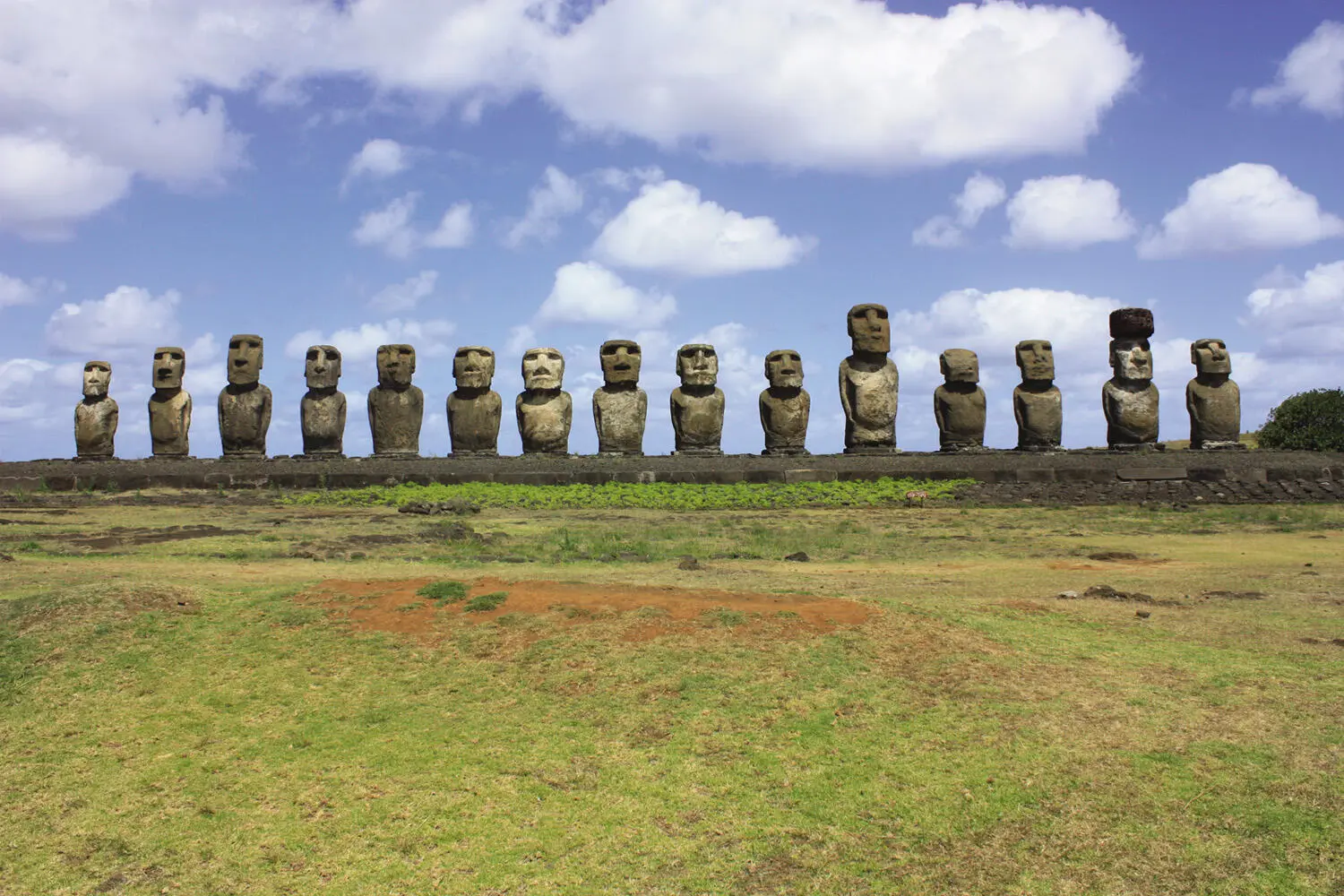
Moai lined up on their ahu – they face inland.
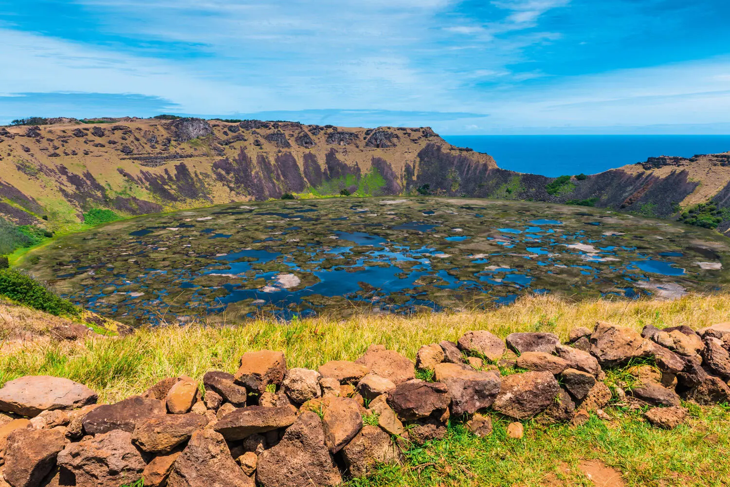
The only source of fresh water on the island: a volcanic crater.
Humanity first arrived here by canoe from the Marquesas Islands, 3,200 km (2,000 miles) to the west, in AD 1200. At first, life was good for the Rapa Nui, as the inhabitants were known. Pollen analysis has shown that the island was once thickly wooded, and had at least three tree species that grew up to 15 m (49 ft) high. Palms could be felled for the building of large canoes, and the hauhau tree could be used to make ropes. There was an abundance of nesting seabirds and fish. Sturdy canoes enabled the fishermen to take porpoises, which became a vital part of the islanders’ diet.
With ample food for survival the population surged as high as 15,000–20,000. The Rapa Nui had spare time, which they spent making moai . This process was not easy and required great organization: the best stone to carve figures from was found at one site; the preferred rock for the headpieces in a different quarry. The tools were made in yet another location.
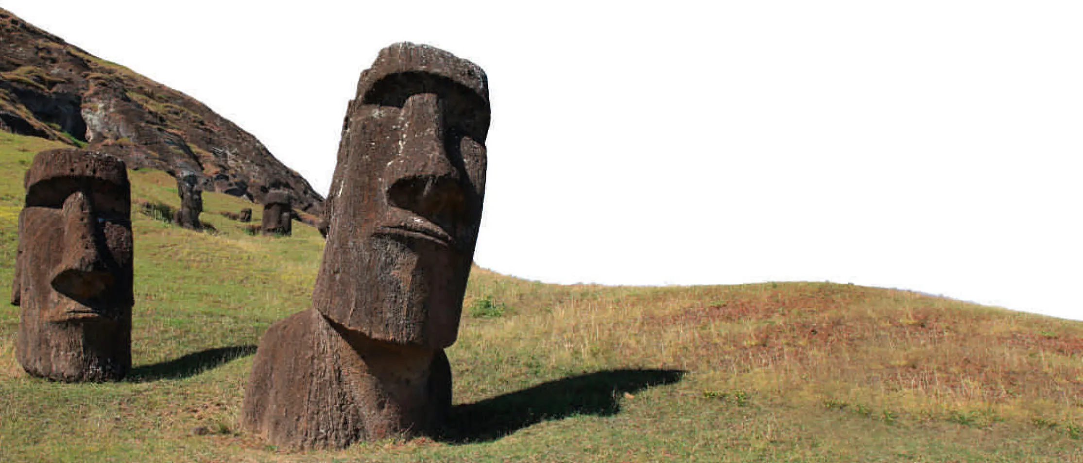
Moai abandoned before they reached their ahu (coastal platforms).
Images of the dead
The Rapa Nui sculpted 887 moai . The completed figures were transported over rough, hilly ground to sites all around the island’s coast. There are competing theories about how this was done. The prevailing thinking was that great numbers of trees were felled to create rollers. The moai were then placed on skids or sleds and pulled across the rollers. Other studies maintain that they were walked to their destinations using a rocking technique controlled by teams using ropes.
At their destination they were placed on stone platforms and aligned to face the island’s interior. They were erected to represent the spirits of ancestors, watching over their descendants.
The tallest moai that the islanders erected stood 10 m (33 ft) high and weighed 82 tonnes; but a partially carved sculpture, found abandoned in the quarry, would have stood 21 m (69 ft) high and weighed 270 tonnes.
The island’s population was organized into clans, and moai creation became an artistic battle for tribal bragging rights: the clan that erected the largest and greatest number of moai could claim the highest status.
As moai production spiralled into a virtual frenzy, huge numbers of mature trees must have been brought down. Trees were also being used as fuel for fires and being felled to create fields. The consumption of natural resources began to exceed the rate at which those resources could be regrown. Around the year 1500, the shortage of trees meant many people were living in caves rather than huts. A century later the island was almost completely deforested.
There will have been a point when the islanders realized they were in trouble. The island is only 20 km (12 miles) across and its central peak has a commanding view. It would have been easy to see where the remaining groves of trees were. The man who felled the last tree must have known the irreversible step he was taking.
Now no more moai could be erected. No more canoes could be built, so there would be no more porpoise to eat and no exodus to a promised land.
The loss of the trees also led to the depletion of nutrients in the soil, which reduced crop yield. Food became scarce. Society could no longer afford the luxury of statue-building and so it stopped. With its resources stripped, the island could not support 15,000 people. The Rapa Nui began to die.
A hard lesson to learn
The mysterious abandonment found by the Europeans was therefore more of a slow suicide – and a sobering example of how devastating a man-made ecological disaster can be. In just 400 years a fertile island paradise had been stripped to a husk.
Unfortunately for the Rapa Nui, life was about to get even worse. Slave raids from Peru, diseases brought by visitors and maltreatment all reduced the population further. By 1877 there were only 111 people on the island.
The island’s history since then has been far from straightforward, but today there are 5,800 inhabitants with descendants of the Rapa Nui accounting for around 60 per cent of the population.
Modern-day visitors make the five hour plane trip out into the Pacific to find a strikingly beautiful island with dramatic cliffs, plunging headlands and rolling swards of grass.
They also marvel at the abandoned moai , the physical remains of a ghost culture. The sculptors left testaments to their industry and ingenuity, but precious few explanations for their actions. For the strange irony of the Rapa Nui is that they adapted to live in relative ease so far from other cultures as to be in another world, and yet they couldn’t live with themselves.
Will future civilizations wonder where we went?
ANI
DATE ABANDONED: Eighteenth century
TYPE OF PLACE: Medieval city
LOCATION: Turkey
REASON: Political
INHABITANTS: c. 200,000
CURRENT STATUS: Ruined
A MILLENNIUM AGO THIS WAS THE CAPITAL CITY OF AN EMPIRE THAT STRETCHED FOR HUNDREDS OF KILOMETRES ACROSS EURASIA. IT SURVIVED VIOLENT CENTURIES OF CLASHING KINGS ONLY TO BE FORGOTTEN WHEN THOSE EMPIRES THEMSELVES FADED. NOW IT LIVES ON IN RUINS, FAR FROM THE TOURIST ATTRACTIONS OF TURKEY, A GILDED SHADOW OF ITS FORMER POWER AND GLORY.
The medieval megacity
There were few more magnificent cities anywhere in the world in AD 1000. Perhaps Baghdad could boast the same architectural majesty, and maybe Constantinople had a similar wealth of international trade. But Rome was in ruins, London was a mere Saxon market town and New York was a wooded island. This is Ani: the key military stronghold, the capital city and the cultural heart of a mighty Armenian empire.
Ani lies deep in eastern Turkey, over 1,450 km (900 miles) from Istanbul. Even the nearest town, Kars, is 48 km (30 miles) away. There is precious little in the hinterland but sheep and goats. The plains here roll on and on in every direction, only ended at last by a horizon of slumbering mountains. This feels a long way from civilization; yet a millennium ago it was the centre of one.
Читать дальшеИнтервал:
Закладка:
Похожие книги на «Abandoned Places: 60 stories of places where time stopped»
Представляем Вашему вниманию похожие книги на «Abandoned Places: 60 stories of places where time stopped» списком для выбора. Мы отобрали схожую по названию и смыслу литературу в надежде предоставить читателям больше вариантов отыскать новые, интересные, ещё непрочитанные произведения.


Обсуждение, отзывы о книге «Abandoned Places: 60 stories of places where time stopped» и просто собственные мнения читателей. Оставьте ваши комментарии, напишите, что Вы думаете о произведении, его смысле или главных героях. Укажите что конкретно понравилось, а что нет, и почему Вы так считаете.