Andrew Taylor - The World of Gerard Mercator - The Mapmaker Who Revolutionised Geography
Здесь есть возможность читать онлайн «Andrew Taylor - The World of Gerard Mercator - The Mapmaker Who Revolutionised Geography» — ознакомительный отрывок электронной книги совершенно бесплатно, а после прочтения отрывка купить полную версию. В некоторых случаях можно слушать аудио, скачать через торрент в формате fb2 и присутствует краткое содержание. Жанр: unrecognised, на английском языке. Описание произведения, (предисловие) а так же отзывы посетителей доступны на портале библиотеки ЛибКат.
- Название:The World of Gerard Mercator: The Mapmaker Who Revolutionised Geography
- Автор:
- Жанр:
- Год:неизвестен
- ISBN:нет данных
- Рейтинг книги:5 / 5. Голосов: 1
-
Избранное:Добавить в избранное
- Отзывы:
-
Ваша оценка:
The World of Gerard Mercator: The Mapmaker Who Revolutionised Geography: краткое содержание, описание и аннотация
Предлагаем к чтению аннотацию, описание, краткое содержание или предисловие (зависит от того, что написал сам автор книги «The World of Gerard Mercator: The Mapmaker Who Revolutionised Geography»). Если вы не нашли необходимую информацию о книге — напишите в комментариях, мы постараемся отыскать её.
The World of Gerard Mercator: The Mapmaker Who Revolutionised Geography — читать онлайн ознакомительный отрывок
Ниже представлен текст книги, разбитый по страницам. Система сохранения места последней прочитанной страницы, позволяет с удобством читать онлайн бесплатно книгу «The World of Gerard Mercator: The Mapmaker Who Revolutionised Geography», без необходимости каждый раз заново искать на чём Вы остановились. Поставьте закладку, и сможете в любой момент перейти на страницу, на которой закончили чтение.
Интервал:
Закладка:
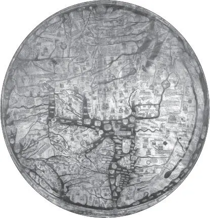
The Hereford mappamundi
Hereford Cathedral Library, Hereford, England
The worldview of the mappaemundi encompassed the soul as well as time and space. The Hereford map, for example, shows not only the towns of the Holy Land but also the expulsion of Adam and Eve from Eden and Noah riding on the waters of the Flood. It admits no conflict between geographic accuracy and religious faith: The holy city of Jerusalem stands unchallenged at the center of the world, while Paradise itself is shown far away in the apparently unreachable East, a round island circled by flames that warn the importunate traveler not to dare too much.
The mappaemundi may have been used for planning journeys from town to town across Europe – marks over the great central city of Paris on the Hereford map suggest that fingernails may have traced a route through it at various times – but it mattered little to the mapmaker that the shape of the coastlines should be so inaccurate, or that the whole map should have been shoehorned so ruthlessly into an all-embracing circle of ocean. Much more important, from his standpoint, God had to be shown overseeing the whole of his kingdom, and the fabulous creatures described by the ancients, such as the bonnacan, with its bull’s head, horse’s mane, and ram’s horns, the screaming mandrake plant, and the death-dealing cockatrice, needed to be faithfully represented to demonstrate the awesome variety of his Creation.
The Hereford mappamundi laid out a world at once mysterious and threatening, where the only hope of safety was to be found in the majestic figure of Christ that dominates the map. To criticize it for inaccuracy would be as foolish as to find fault with Picasso’s famous painting as a street guide to Guernica. Yet for the rapidly growing world of the fifteenth and sixteenth centuries, the mappaemundi were quickly proved inadequate. A new geography was needed to enable sailors to plot a reliable course across the oceans and to represent the world they were revealing.
Three events in the half century or so before Mercator’s birth made his achievement as a cartographer both possible and necessary. The first was the rediscovery of the geographic writings of Ptolemy, brought back into Europe after hundreds of years; the second was the development of printing, which meant that Ptolemy’s ideas could be spread more quickly and efficiently than the monks who had copied them by hand could ever have dreamed; and the third was the voyage of Christopher Columbus, who, looking for Asia, discovered America.
Other explorers had made great discoveries around the coast of Africa and in Asia about lands that were already dimly known about, but Columbus’s voyage proved that there really was a world elsewhere. The looming shadows that had marked the boundaries of geographic knowledge ever since man first looked about him were beginning to part, to reveal a reality far different from anything the ancient scholars had imagined.
Chapter Two Forgotten Wisdom
FOR THE SCHOLARS of fifteenth–and sixteenth-century Europe, who looked on the past with reverence, the rediscovery of Ptolemy’s writing in the early fifteenth century was a revelation and an inspiration. The task of translating the Geographia into Latin from an original Greek manuscript in Byzantium was begun by the Byzantine scholar Manuel Chrysoloras and finished in 1406 by his pupil Jacobus Angelus in Tuscany.
In the Arab world, the Almagest and the Geographia had both been known by then for some five hundred years, and practically every Islamic cartographer either mentioned, quoted, or silently borrowed from what they called the Kitab gagrafiya (Book of Geography). However, not until the fall of Byzantium to the Turks in 1453 did refugees bring the manuscripts to the West in any numbers. Monks in Florence translated them from Greek into Latin and wrote them out painstakingly by hand, making copies available over the following years, first without maps, then with regional maps, and finally with world maps drawn according to Ptolemy’s recommendations. At the time of Mercator’s birth, they were still fresh and exciting – a philosophical framework into which the new discoveries about the extent and shape of the world could be incorporated.
Ptolemy’s books had been copied and copied again in the Arab world for centuries prior to the time they resurfaced in Europe; by then, they almost certainly included the additions and amendments of generations of nameless and unknown thinkers. Nonetheless, however much or little of them had actually been written by Ptolemy himself, they were a virtual synthesis of classical scientific knowledge.
The Geographia concentrated on the arts and skills of mapmaking, discussing the comparative merits of flat maps and globes, and arguing through the mathematics of how a map should be constructed and how the world could be divided into the three continents of Europe, Asia, and northern Africa. The great undiscovered continent that Ptolemy believed lay to the south turned the Indian Ocean into an inland sea, and in the East, the known world petered out in the unexplored lands beyond the Ganges. West of the Pillars of Hercules, at the mouth of the Mediterranean, of course, he described nothing but sea and a few scattered islands.
Fresh versions appeared year by year, with cartographers adapting and expanding Ptolemy’s work. An edition was printed in Cologne in 1475 without maps; only two years later, the interest and the technology existed to prepare a version in Bologna that included twenty-six copper engravings based on Ptolemy’s text. By the time Mercator was working, the book’s reputation was established among scholars, even though the great voyages of the fifteenth and sixteenth centuries were already demonstrating its limitations.
For all the dedicated work of the monastic copyists, it was the development of printing that allowed Ptolemy’s work to be widely read in Europe. The impact of Johannes Gutenberg’s first press with movable type in the 1450s is hard to exaggerate. In the Low Countries alone, more than four thousand different books were produced in the first decades of the sixteenth century; there were in excess of 130 printers there, half of them in the thriving city of Antwerp.
Ptolemy’s Geographia was only one of a range of classical works that flooded off the new presses to feed the public’s apparently insatiable appetite. As these books were shipped around the continent, they invigorated and inspired learning not just in the palaces, monasteries, and great houses that had always collected rare and expensive manuscripts, but also in the studies of poor students. Without the explosion of printing, Mercator would never even have seen many of the books that enthused him at Leuven. He would certainly never have gathered around him the personal library in which he delighted in the German city of Duisburg.
However, for all the excitement that the rediscovery of Ptolemy’s Geographia stirred up, his three continents soon could no more be accepted as they stood than could the old T-O maps or the mappaemundi. There had been rumors for centuries of scattered islands far away to the west, but no one had any idea of the vast extent of the newly discovered land. Just twenty years before Mercator was born, the discovery of America had revealed a new world of which Ptolemy and his predecessors never dreamed, confounding the ancient view that the Earth was limited to the three continents of Europe, Asia, and the strange and mysterious Africa.
Читать дальшеИнтервал:
Закладка:
Похожие книги на «The World of Gerard Mercator: The Mapmaker Who Revolutionised Geography»
Представляем Вашему вниманию похожие книги на «The World of Gerard Mercator: The Mapmaker Who Revolutionised Geography» списком для выбора. Мы отобрали схожую по названию и смыслу литературу в надежде предоставить читателям больше вариантов отыскать новые, интересные, ещё непрочитанные произведения.


Обсуждение, отзывы о книге «The World of Gerard Mercator: The Mapmaker Who Revolutionised Geography» и просто собственные мнения читателей. Оставьте ваши комментарии, напишите, что Вы думаете о произведении, его смысле или главных героях. Укажите что конкретно понравилось, а что нет, и почему Вы так считаете.