J. Steers - The Sea Coast
Здесь есть возможность читать онлайн «J. Steers - The Sea Coast» — ознакомительный отрывок электронной книги совершенно бесплатно, а после прочтения отрывка купить полную версию. В некоторых случаях можно слушать аудио, скачать через торрент в формате fb2 и присутствует краткое содержание. Жанр: unrecognised, на английском языке. Описание произведения, (предисловие) а так же отзывы посетителей доступны на портале библиотеки ЛибКат.
- Название:The Sea Coast
- Автор:
- Жанр:
- Год:неизвестен
- ISBN:нет данных
- Рейтинг книги:4 / 5. Голосов: 1
-
Избранное:Добавить в избранное
- Отзывы:
-
Ваша оценка:
The Sea Coast: краткое содержание, описание и аннотация
Предлагаем к чтению аннотацию, описание, краткое содержание или предисловие (зависит от того, что написал сам автор книги «The Sea Coast»). Если вы не нашли необходимую информацию о книге — напишите в комментариях, мы постараемся отыскать её.
The Sea Coast — читать онлайн ознакомительный отрывок
Ниже представлен текст книги, разбитый по страницам. Система сохранения места последней прочитанной страницы, позволяет с удобством читать онлайн бесплатно книгу «The Sea Coast», без необходимости каждый раз заново искать на чём Вы остановились. Поставьте закладку, и сможете в любой момент перейти на страницу, на которой закончили чтение.
Интервал:
Закладка:
In England and Wales the relation of coast to the structure of the interior of the country is perhaps less impressive. Geological maps emphasise the strike of the Jurassic and Cretaceous beds, and the scarps of the Cotswolds and Chiltern Hills, but in eastern England the influence of either the trend or of the rocks composing these formations is small indeed. In the coastal parts of Holderness and Lincolnshire the Cretaceous beds are completely hidden by boulder clay, and in north Norfolk, apart from an outcrop at Hunstanton, the Chalk lies behind a wide fringe of salt marsh, and only makes a final appearance on the foreshore at and near Sheringham.
From the Border to Flamborough Head, rock type locally has a great effect on the coastal scenery (see here), although the connection between the coastal scenery and the structure of both coast and interior is not striking. On the coast itself this is partly because the extensive sandy beaches and long lines of dunes on the Northumberland coast hide it. The Carboniferous rocks of Northumberland and Durham are roughly concentric around The Cheviot, and for many miles south of Berwick they (including the Calciferous sandstone series) outcrop on the coast in such a way as to give rapidly alternating beds of usually thin sandstones, shales, and limestones locally intruded by the Whin Sill, which produces the most interesting features, including the Farne Islands. The Millstone Grit and Coal Measures follow to the south, and form the coastline of the southern part of Northumberland. The Magnesian limestone, of Permian age, makes nearly the whole of the Durham coast.
In the Cleveland district of Yorkshire, the Jurassic rocks are gently folded along an east and west axis, but near the coast, local anticlines and synclines modify the major trend. The low ground near the Tees mouth is clearly related to the soft Permian and Triassic rocks thereabouts.
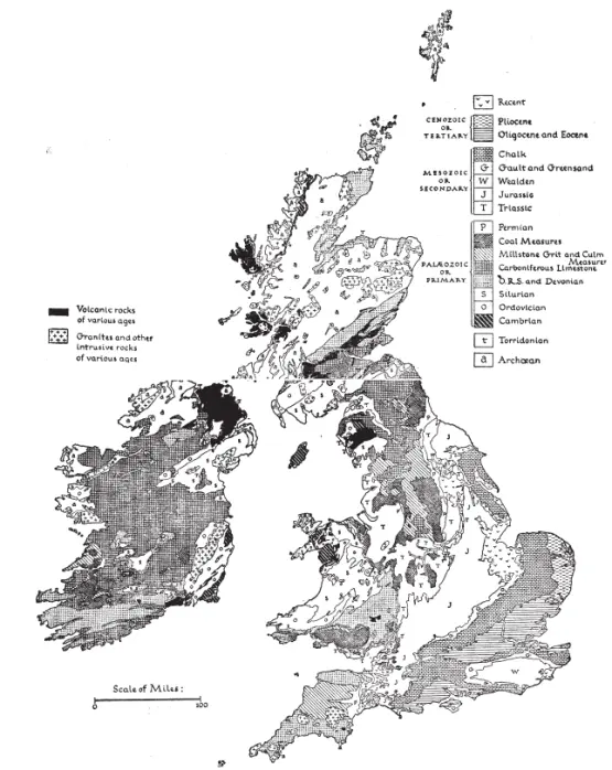
FIG. 1—A simplified Geological map of the British Isles. (Based on Geological Survey)
The north-east and south-west trend so characteristic of Scotland reappears in the Lake District and in Wales. In the Lakes the older rocks—the Skiddaw Slates, Borrowdale Volcanics, and Upper (Silurian) Slates—are approximately parallel with the folds in the Southern Uplands, but they do not reach the coast. The history of the Lake District is long and complicated; suffice it to say that before the final doming which immediately preceded its present form, Carboniferous and newer rocks had been deposited over the older Palaeozoics. As a result of the doming in Tertiary time, the newer rocks have been worn away from the centre of the district, but remain as a girdle on the coast and in the Eden valley.
North and central Wales show the Caledonian trend to advantage. The orientation of the Lleyn peninsula conforms to it, as also do the major outcrops in Anglesey. Between, approximately, Aberystwyth and Pembrokeshire, the coast of Cardigan Bay runs in the same direction, but the exact significance of this is uncertain, although the coast may conform to a structural line parallel with the central Wales syncline and the Teifi and Towy anticlines. North and central Wales are built around the dome of Cambrian rocks, the outcrop of which coincides fairly closely with Merionethshire.
There is no need to enquire in detail into the structure of central England, but the significance of a line running from Carmarthen Bay to Church Stretton, and then northwards to the great faults that border the western side of the Pennines, and perhaps as far as the Solway, needs brief mention. The line separates to the west a tract in which prolonged sedimentation went on throughout Lower Palaeozoic times. There were many movements of the sea floor, and at times, especially in the Ordovician, there was a great deal of vulcanicity, which has given us the characteristic scenery of Cader Idris, much of the Lleyn peninsula, and the Borrowdales in the Lake District. But from the early part of the Cambrian until the close of the Silurian this western sea was an area in which thousands of feet of sediment slowly accumulated. To the east of this long line there was a continental area on the margins of which the sea occasionally spread and laid down sediments. The contrast between the slowly subsiding western region and the continental areas to the east is of great significance in the formation of the Caledonian mountains.
In the region now called the Southern Uplands of Scotland, there was also a sea in early Palaeozoic times, and in the waters more distant from the coast, thin and fine shales slowly accumulated. In the more coastal parts, sedimentation was far more rapid. A comparison of the rocks in the Hawick and Girvan districts soon reveals the difference of conditions.
In the North-west Highlands region there was also an early Palaeozoic sea. The Cambrian rocks of that area were deposited in it, but its later history is obscure.
In all three regions there was great tectonic activity at the close of Silurian times. For whatever may have been the reason, the sediments which had accumulated in the seas were violently squeezed and folded, and later raised into mountain ranges. The details vary from place to place, but the general direction of movement was from the south-east, and it is this which has produced the marked north-east and south-west grain so noticeable in these regions of Caledonian folding.
In South Wales and in southern England the trend of the rocks is more nearly east and west. This is exemplified with great clarity in the coalfield of South Wales, and the adjacent folding in the Tenby and Gower peninsulas. It occurs in the Mendips, and in Cornwall and Devon. Farther east it gives rise to the characteristic scenery of the Isles of Purbeck and Wight, and of the Weald. The main direction of the syncline of the London Basin is in accord, and so also is that of the lower Bristol Channel.
The east-west trend in the south of Britain is the result of folding movements of two distinct and long separated periods of time. The folding of the coalfield and adjacent parts of South Wales took place at the end of Carboniferous times, and is named the Armorican folding. The much newer folding of the Tertiary period, the Alpine folding, followed the same east and west direction, but also involved much newer rocks. In Kent the surface folding, which is the key to so much of the scenery, is generally parallel to the underlying folds which have been studied in the deeply buried Kent coalfield. This ancient folding is probably continuous below the surface with that of South Wales on the one side, and the Boulonnais, Belgian coalfield, and the Ruhr on the other.
The Armorican and Alpine folds are largely responsible for the major pattern of our southern coasts. The Chalk headlands of the North and South Forelands, and Beachy Head, the sweeping curves in the softer Wealden and Tertiary beds of the Hampshire basin, the lozenge-shape of the Isle of Wight, the intricate relation of structure and coastal scenery in Purbeck, the disposition of the rocks in Cornwall on either side of the Watergate anticline, the arrangement of the beds in the Ilfracombe district, the beautiful symmetry of the coasts of Gower and Tenby, and the final meeting in western Pembrokeshire of the Armorican and Caledonian folds—the latter almost east and west at this point—all illustrate this.
North of the Thames the main direction of strike is north-east and south-west, but in Norfolk and Lincolnshire it becomes nearly north and south. The escarpments of the Cotswolds and Chilterns and of the adjacent hills indicate that the Mesozoic rocks of which they are formed, at one time extended much farther to the north-west. The occurrence of Jurassic rocks in the Western Isles of Scotland, and of Chalk beneath the basalts of County Antrim, imply that a great blanket of Mesozoic rocks formerly spread over most of Britain. It was on these that our present river systems originated. Whether the present south-west and north-east trend of scarplands is the direct outcome of erosive processes, or whether it is in part the result of tectonic movement need not concern us here.
Читать дальшеИнтервал:
Закладка:
Похожие книги на «The Sea Coast»
Представляем Вашему вниманию похожие книги на «The Sea Coast» списком для выбора. Мы отобрали схожую по названию и смыслу литературу в надежде предоставить читателям больше вариантов отыскать новые, интересные, ещё непрочитанные произведения.


Обсуждение, отзывы о книге «The Sea Coast» и просто собственные мнения читателей. Оставьте ваши комментарии, напишите, что Вы думаете о произведении, его смысле или главных героях. Укажите что конкретно понравилось, а что нет, и почему Вы так считаете.