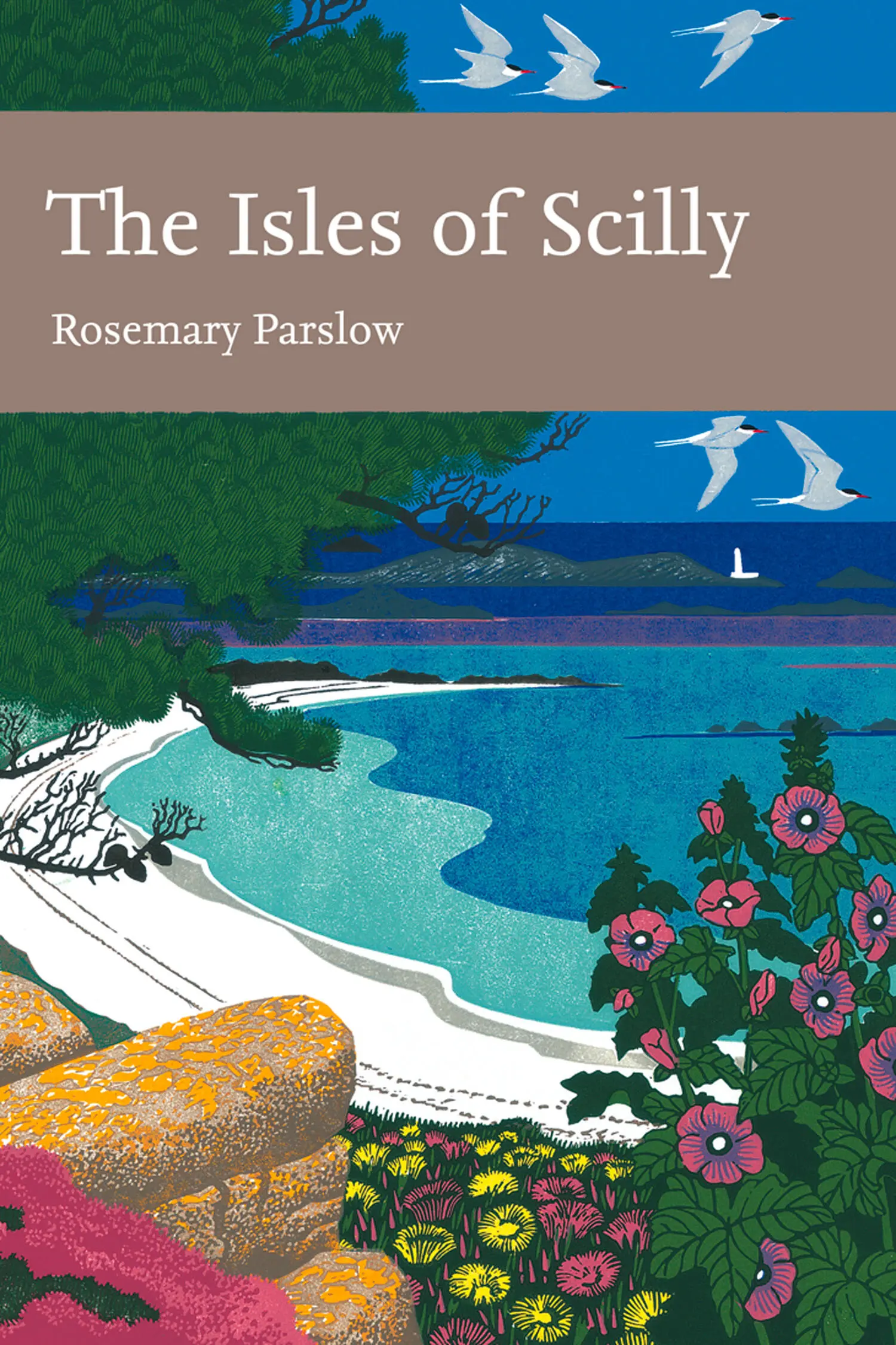
Rosemary Parslow - The Isles of Scilly
Здесь есть возможность читать онлайн «Rosemary Parslow - The Isles of Scilly» — ознакомительный отрывок электронной книги совершенно бесплатно, а после прочтения отрывка купить полную версию. В некоторых случаях можно слушать аудио, скачать через торрент в формате fb2 и присутствует краткое содержание. Жанр: unrecognised, на английском языке. Описание произведения, (предисловие) а так же отзывы посетителей доступны на портале библиотеки ЛибКат.
- Название:The Isles of Scilly
- Автор:
- Жанр:
- Год:неизвестен
- ISBN:нет данных
- Рейтинг книги:3 / 5. Голосов: 1
-
Избранное:Добавить в избранное
- Отзывы:
-
Ваша оценка:
The Isles of Scilly: краткое содержание, описание и аннотация
Предлагаем к чтению аннотацию, описание, краткое содержание или предисловие (зависит от того, что написал сам автор книги «The Isles of Scilly»). Если вы не нашли необходимую информацию о книге — напишите в комментариях, мы постараемся отыскать её.
The Isles of Scilly — читать онлайн ознакомительный отрывок
Ниже представлен текст книги, разбитый по страницам. Система сохранения места последней прочитанной страницы, позволяет с удобством читать онлайн бесплатно книгу «The Isles of Scilly», без необходимости каждый раз заново искать на чём Вы остановились. Поставьте закладку, и сможете в любой момент перейти на страницу, на которой закончили чтение.
Интервал:
Закладка:
NATURE CONSERVATION DESIGNATIONS
Currently the Isles of Scilly are covered by a plethora of designations relating in some way to nature conservation.
The whole coastline of the Isles of Scilly was designated a Heritage Coast in 1974.
Scilly is a candidate Special Area of Conservation (cSAC) under the European Habitats Directive.
A Special Protection Area (SPA) (for birds) covers 4.09km2.
Scilly is a Ramsar site, an international important-wetland designation.
Scilly was designated a Conservation Area in 1975.
Twenty-six sites have been designated Sites of Special Scientific Interest (SSSI) by English Nature. Of these five are geological sites.
The Isles of Scilly has been a Voluntary Marine Park since 1987 – this includes the whole area within the 50m depth contour line.
Scilly was designated an Area of Outstanding Natural Beauty (AONB) in 1975 – it includes ‘all the islands and islets above mean low water that together form the Isles of Scilly’. The total area covered is 16km2. Scilly is the smallest AONB in the country; also the only one under a single local authority. The Management Plan for the AONB was published in 2004.
STUDYING THE FLORA AND FAUNA OF THE ISLES OF SCILLY
Although many of the visitors to the Isles of Scilly over the centuries have commented on the natural history of the islands, most of what has been written has concentrated on the most obvious groups. Authoritive books have covered plants, birdlife, butterflies and moths, but many of the marine species, insects and more difficult groups are the subject of papers in scientific journals or rather inaccessible unpublished reports held by English Nature and other bodies. Recently there has been a resurgence of interest in these other groups, especially invertebrates and marine life, which had otherwise been left to a small number of specialists.
For many years botanists have been well served by a Flora (Lousley, 1971), but it is now due for an update as there is a great deal of new botanical information available. Some plant hunters whose aim is to record rare plants, and especially alien species, are regular visitors to the islands.
Birds have tended to attract the lion’s share of attention since the late 1950s, when the St Agnes Bird Observatory became a focus for birdwatchers hoping to see rare and unusual migrant and vagrant species. October is still the most popular month for birdwatchers to visit Scilly. This is an extraordinary phenomenon; it has to be seen to be believed. Hundreds of enthusiasts, bristling with telescopes, pagers and binoculars, arrive in Scilly intent on seeing rare migrant birds. These birders mostly have well-defined patterns of behaviour, usually travelling en masse to wherever there is news of some exciting bird. So it is not unusual to see them all gathered in one place, behind lines of telescopes waiting patiently for a glimpse of their quarry. In the evenings many will attend the ‘count’, when the tally of the day’s finds are recorded.
The marine habitat might seem to be rather neglected. Although there are organised field trips to Scilly to study marine ecology, most of the information stays in student dissertations. But for every child visiting the islands half the fun is exploring rock pools. Now, with plenty of opportunities to dive or snorkel, the underwater life is becoming much better known. Underwater safaris, glass-bottomed boats and swimming with seals and seabirds are making this fascinating medium much more accessible to the general public.
Some of these visitors to Scilly are going to take more than a casual interest in what they see. Hopefully they will contribute records and notes that will lead to further expansion of our knowledge of the natural history of the islands. Since its inception the Isles of Scilly Bird Group has produced a report that also includes notes, short papers and reports on natural history subjects other than birds – the Isles of Scilly Bird & Natural History Review . Perhaps this book too will encourage an interest in the fascinating natural history of the Isles of Scilly.
The chapters that follow are arranged to give an overview of the geology, something of the history, the people who contributed to our knowledge of the natural history of the islands, the individual islands, the main habitats, and the major groups of flora and fauna. Descriptions of some of the plant communities are included as an appendix.
CHAPTER 2 Geology and Early History
There are signs of Bronze Age man on every island in Scilly.
Charles Thomas (1985)
GEOLOGY
AT FIRST GLANCE the Ordnance Survey’s geological map of the Isles of Scilly appears to be something of a disappointment: almost the whole of the land shown on the map is coloured in the same shade of red-brown, representing granite. A granite batholith, the Cornubian batholith, extends as a series of cupolas or bosses along the Southwest Peninsula from Dartmoor to Land’s End and the Isles of Scilly, ending at the undersea mass of Haig Fras 95km further on and slightly out of line, presumably due to faulting (Edmonds et al., 1975; Selwood et al., 1998). Originally the rocks were a softer, slatey rock called killas; this was altered by pressure from the granite boss as it was extruded and pushed up into the killas, which was later eroded and now only exists as rock called tourmalised schist, found as a narrow dyke-like patch on the northwest of St Martin’s (Anon., Short Guide to the Geology of the Isles of Scilly ).
The Scilly granite is very similar to that found in Cornwall, and was classified by Barrow (1906) into different types, the main ones being the older, coarse-grained G1, which is found mainly around outer the rim of the islands, and G2, which is finer-grained and is mostly in the central part of the islands and has often been intruded into G1. The two types of granite merge into each other without any obvious line of demarcation. Characteristically the granites are made up of quartz and crystals of feldspar, muscovite mica, biotite mica and other
FIG 7.Loaded Camel Rock at Porth Hellick, St Mary’s, May 2006. (Richard Green)
minerals. Much of the rock is beautifully striped through with veins and dykes, mostly narrow and usually white or black according to the infilling; white quartz or black tourmaline crystals can be found in these dykes, and rarely larger crystals of amethyst quartz. A vein of beautiful amethyst quartz that runs through some of the rocks to the north of St Agnes at one time had large, visible crystals, but most have since been taken by collectors. It is still possible to find smaller veins of crystals, and some beach pebbles have small layers of crystals running through them.
Another characteristic of the granite is the weathering along the veins and softer areas in the rock. The cooling and pressures have already formed these into very distinctive vertical and horizontal cracks, and erosion by weather and the sea then combine to produce the most extraordinary natural sculptures. Some of the most impressive examples can be seen on Peninnis Head and along the east coast of St Mary’s, but all the islands have examples. Some of these rocks have been given fanciful names: Pulpit Rock, Monk’s Cowl, Tooth Rock, Loaded Camel (Fig. 7). A curious type of formation seen frequently in Scilly is a rock basin in the top of a granite boulder where rainwater has weakened feldspar and released quartz crystals, which apparently have blown round and round to form a natural bowl.
Surface geology
When the granite weathers it eventually becomes reduced to sand. Blown sand is an important constituent of the soils of all the islands as well as forming the beautiful white beaches and the sand bars that link many of the higher parts of the islands. Ram (also known as head or rab) is a cement-like material formed by the breakdown of periglacially frost-shattered granite fragments that forms deposits around the bases of granite carns, in valleys and especially in the cliffs (Fig. 8). It is often excavated from ‘ram pits’ to be used by the islanders as a mortar in building work and sometimes as a road surface. Alluvium is found under the Porthloo fields, and at Lower and Higher Moors. Small patches of gravel found near the daymark on St Martin’s and at a few other places are probably of glacial origin – see below.
Читать дальшеИнтервал:
Закладка:
Похожие книги на «The Isles of Scilly»
Представляем Вашему вниманию похожие книги на «The Isles of Scilly» списком для выбора. Мы отобрали схожую по названию и смыслу литературу в надежде предоставить читателям больше вариантов отыскать новые, интересные, ещё непрочитанные произведения.

Обсуждение, отзывы о книге «The Isles of Scilly» и просто собственные мнения читателей. Оставьте ваши комментарии, напишите, что Вы думаете о произведении, его смысле или главных героях. Укажите что конкретно понравилось, а что нет, и почему Вы так считаете.