K. Edwards - Collins New Naturalist Library
Здесь есть возможность читать онлайн «K. Edwards - Collins New Naturalist Library» — ознакомительный отрывок электронной книги совершенно бесплатно, а после прочтения отрывка купить полную версию. В некоторых случаях можно слушать аудио, скачать через торрент в формате fb2 и присутствует краткое содержание. Жанр: unrecognised, на английском языке. Описание произведения, (предисловие) а так же отзывы посетителей доступны на портале библиотеки ЛибКат.
- Название:Collins New Naturalist Library
- Автор:
- Жанр:
- Год:неизвестен
- ISBN:нет данных
- Рейтинг книги:4 / 5. Голосов: 1
-
Избранное:Добавить в избранное
- Отзывы:
-
Ваша оценка:
Collins New Naturalist Library: краткое содержание, описание и аннотация
Предлагаем к чтению аннотацию, описание, краткое содержание или предисловие (зависит от того, что написал сам автор книги «Collins New Naturalist Library»). Если вы не нашли необходимую информацию о книге — напишите в комментариях, мы постараемся отыскать её.
Collins New Naturalist Library — читать онлайн ознакомительный отрывок
Ниже представлен текст книги, разбитый по страницам. Система сохранения места последней прочитанной страницы, позволяет с удобством читать онлайн бесплатно книгу «Collins New Naturalist Library», без необходимости каждый раз заново искать на чём Вы остановились. Поставьте закладку, и сможете в любой момент перейти на страницу, на которой закончили чтение.
Интервал:
Закладка:
The open breezy highlands of the Peak District are remnants of the peneplain then produced. The features described above are best exemplified in the limestone uplands where the rock is almost uniform in quality. An excellent viewpoint from which to see them in profile is from the summit of Thorpe Cloud. In the moorland areas in the north the alternating grits and shales have produced a rugged surface (Plate 1, see here). Upstanding peaks were absent, but even in those far-off days the plateaux and ridges rose above the general level of that ancient peneplain. Ancient indeed, for it dates back to early Pliocene times, when for several million years land and sea remained relatively stable with only small oscillations of level. The denuding processes continued their work without serious interruption until it was accomplished. At that time the Peak District did not rise above the surrounding country as it does now, for its surface was only a small part of an extensive peneplain that sloped away gently towards the far distant sea, the sea whose nearly constant level had for so long a time exerted a controlling influence that was felt along the whole length of every river and stream and across the breadth of the whole countryside.
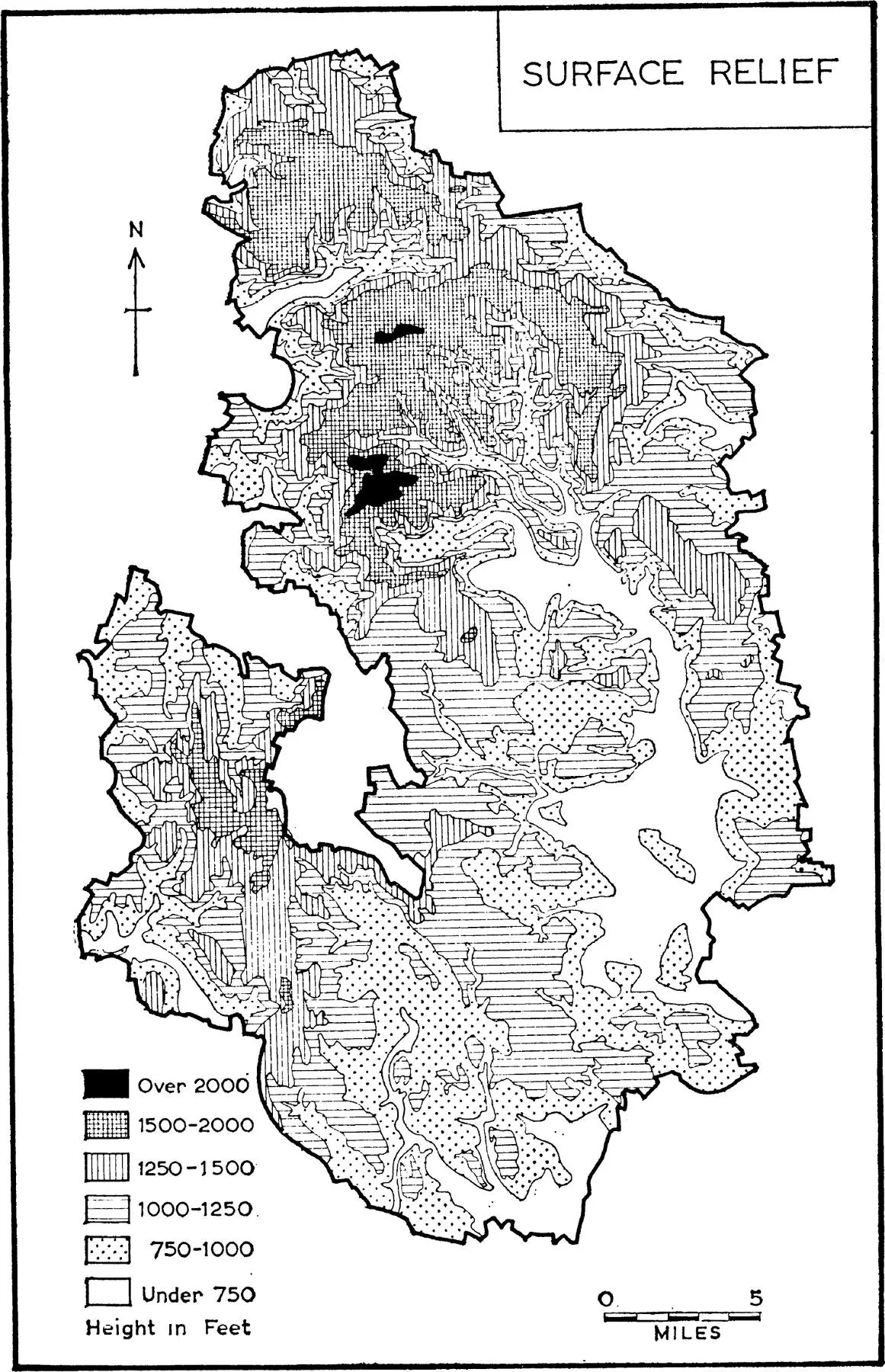
Fig. 5. Surface relief of the Peak National Park
BEYOND THE DALES
For many tourists the word Derbyshire spells “dales.” It is the dales they love to explore. It is up the dales they hike. When eventually they emerge into the upland, as for instance out of Lathkill Dale they lose interest for “there is nothing to see,” nothing but stone walls and tame pastures. Nevertheless, for a full appreciation of the more exciting vistas within the dales the story of these uplands must be told.
The sequence of events detailed in the last section is known as a cycle of erosion . Whenever the level of the land rises or that of the sea sinks, the current “cycle” is interrupted or even ended. A general movement of this kind took place about the middle of the Pliocene period. The whole landscape was uplifted about 300 feet and remained at the new level for a long time. The rivers were rejuvenated and recommenced excavating their channels, first of all in their lower reaches. The point near which the steep new bed joins up with the gently sloping old one is commonly called the knick point . Below this the newly formed valley was at first a narrow gorge and ran like a trench along the floor of the broad, open, ancient valley of the former cycle. Above the knick point that valley remained unchanged. The river continued excavating its channel and the knick point receded upstream along nearly the whole length of the former valley.
Meanwhile the sides of the gorge were worn by weathering agencies into steep and then gentle slopes. The gorge was thus slowly converted into a wide valley lying within the limits of the old one. Along its margin where the steeper side of the new valley merged into the floor of the old one there was a “break of slope,” essentially a greatly elongated extension of the knick point. Had this widening process been carried on to its utmost limit all traces of the older landscape would have been destroyed. Fortunately this cycle of erosion was interrupted in late Pliocene times and consequently relics of the earlier landscape survive in the loftiest portions of this upland.
The late Pliocene uplift raised the general level another 200 feet and all the weathering machinery was set going once more. Through out the Pleistocene and later times, river channels were worn deeply once more and thus the dales as now seen came into being as the youngest features in the Derbyshire scenery.
That, then, in rapidly drawn outline is the general story of this limestone scenery in the Peak District. Further details must now be considered and these vary from dale to dale mainly in association with the size of the streams.
The Lathkill, though only a small stream, provides a pocket edition of the whole story. In the centre of its basin lies Monyash surrounded by a broad open valley formed mainly in mid-Pliocene times. The high ground enclosing this basin bears the last traces of the early Pliocene peneplanation. Downstream from Monyash the floor of the valley is gashed by the dale, the excavation of which was begun in late Pliocene times and continued until now.
The survival of so many traces of the early phases in the development of the landscape is largely due to the fact that it lies wholly within the limestone region. Apart from the Lathkill there are no surface streams. Had such streams been present they would have inscribed an intricate pattern of new valleys and in doing so would have removed still further and larger portions of the ancient surface. The rain, however, instead of flowing off along the surface descended down cracks and joints in the rock and dissolved out underground channels along which it journeyed to the newly forming dale. Thus many of the dales are now dry at the surface, Gratton Dale being a good example (Plate VIIb, see here).
It must not be supposed that the relics of the more ancient landscape have survived the passage of ages without undergoing change. On the contrary the whole of the limestone area is like a marble statue which has been exposed to the weather for a long time. Every fall of rain which has washed its surface has dissolved away some of the marble and gradually destroyed the finer details of the carving. But the major features of the face, chin, nose and eyes can still be recognised as such. So though the limestone of this upland has been washed by rain for 5, 10 or 15 million years, the major features originally carved upon its surface can still be recognised.
The water which disappears underground is by no means idle. It finishes its downward journey when it reaches the water-table, that is to say the surface below which all cracks and joints are already filled with water. This surface differs from that of a lake in that it is not flat and horizontal but has a general slope roughly parallel to that of the surface of the countryside above it. The water newly arrived from above now flows along this watery surface, dissolving the limestone away on either side of the crack which forms its path. The level of the water-table rises and falls according as the season is wet or dry and consequently the crack is widened into a tunnel or cave within the limits of that rise and fall. Such a cave may be seen soon after entering the dale from its upper end. In a rainy season the water-table rises above the floor of the dale and the stream is then seen issuing from the cave as a surface stream. In times of drought the water-table sinks and the stream, finding that its underground channel is enough, disappears from the surface and continues its course below ground. With this alternating rise and fall of the water the roof of the underground channel is being gradually dissolved away and ultimately collapses and thus a new and romantic addition is introduced into the floor of the dale. This type of deepening has been going on in all the dales since late Pliocene times.
The limestone varies in quality from place to place throughout the uplands. Sometimes it is rich in fossils which are slightly less soluble than the rock itself. This is particularly the case where coral or shelly reefs existed on the floor of the Carboniferous sea. At such places the rock is less rapidly dissolved than is the surrounding limestone and so it stands up as a more or less prominent hill known as a reef knoll. Thorpe Cloud, Bunster, Wetton and Gratton Hills are examples of such knolls.
One important result accruing from the solvent action of rainwater upon the limestone is that the insoluble residue remains on the surface and accumulates to form soil. This is particularly the case where the surface is almost level, for then rain-wash and soil creep have only slight effect. The soil is then said to be stationary. Where the surface has a marked slope these two factors come into action more vigorously and the soil is transported downhill. On such slopes the soil covering is thin but in the adjoining valley it is deep. These differences from place to place exert an important influence upon the agriculture of the upland.
Читать дальшеИнтервал:
Закладка:
Похожие книги на «Collins New Naturalist Library»
Представляем Вашему вниманию похожие книги на «Collins New Naturalist Library» списком для выбора. Мы отобрали схожую по названию и смыслу литературу в надежде предоставить читателям больше вариантов отыскать новые, интересные, ещё непрочитанные произведения.


Обсуждение, отзывы о книге «Collins New Naturalist Library» и просто собственные мнения читателей. Оставьте ваши комментарии, напишите, что Вы думаете о произведении, его смысле или главных героях. Укажите что конкретно понравилось, а что нет, и почему Вы так считаете.