W. Finden - The Ports, Harbours, Watering-places and Picturesque Scenery of Great Britain (Vol. 1&2)
Здесь есть возможность читать онлайн «W. Finden - The Ports, Harbours, Watering-places and Picturesque Scenery of Great Britain (Vol. 1&2)» — ознакомительный отрывок электронной книги совершенно бесплатно, а после прочтения отрывка купить полную версию. В некоторых случаях можно слушать аудио, скачать через торрент в формате fb2 и присутствует краткое содержание. Жанр: unrecognised, на английском языке. Описание произведения, (предисловие) а так же отзывы посетителей доступны на портале библиотеки ЛибКат.
- Название:The Ports, Harbours, Watering-places and Picturesque Scenery of Great Britain (Vol. 1&2)
- Автор:
- Жанр:
- Год:неизвестен
- ISBN:нет данных
- Рейтинг книги:4 / 5. Голосов: 1
-
Избранное:Добавить в избранное
- Отзывы:
-
Ваша оценка:
The Ports, Harbours, Watering-places and Picturesque Scenery of Great Britain (Vol. 1&2): краткое содержание, описание и аннотация
Предлагаем к чтению аннотацию, описание, краткое содержание или предисловие (зависит от того, что написал сам автор книги «The Ports, Harbours, Watering-places and Picturesque Scenery of Great Britain (Vol. 1&2)»). Если вы не нашли необходимую информацию о книге — напишите в комментариях, мы постараемся отыскать её.
The Ports, Harbours, Watering-places and Picturesque Scenery of Great Britain (Vol. 1&2) — читать онлайн ознакомительный отрывок
Ниже представлен текст книги, разбитый по страницам. Система сохранения места последней прочитанной страницы, позволяет с удобством читать онлайн бесплатно книгу «The Ports, Harbours, Watering-places and Picturesque Scenery of Great Britain (Vol. 1&2)», без необходимости каждый раз заново искать на чём Вы остановились. Поставьте закладку, и сможете в любой момент перейти на страницу, на которой закончили чтение.
Интервал:
Закладка:
About the time of the Conquest, the manors of Hart and Hartness belonged to Fulk de Panell; and, upon the marriage of his daughter Agnes with Robert de Brus, one of the Norman followers of William I., they came, with other rich manors in Yorkshire and in Durham, into the possession of that family. Upon Robert Bruce, a descendant of the above-named Robert de Brus, succeeding to the crown of Scotland in 1306, all his English estates were confiscated by Edward I., who granted the manor of Hart and the borough of Hartlepool to Robert de Clifford, "saving the rights of the Bishops of Durham," under whom, since 1189, the property had been held.
In 1201, King John granted a charter to Hartlepool, conferring upon the burgesses the same privileges as those of Newcastle-upon-Tyne; and in 1230, Richard le Poor, Bishop of Durham, granted another charter, appointing a mayor and other officers for the government of the town. In 1593, Queen Elizabeth granted a new charter, under which the affairs of the borough have been since regulated.
From the reign of King John to that of James I., Hartlepool was the most considerable port in the county of Durham; but from the latter period till about seven years ago, its importance as a place of trade appears to have greatly declined: and from 1730 to 1832, its condition was that of a small fishing town, scarcely visited by any ships, except colliers belonging to Sunderland and Newcastle, which occasionally sought refuge in its harbour during a storm. In 1832, a bill was obtained for the purpose of improving the harbour and forming a dock at Hartlepool; and since that period a considerable portion of the projected works have been finished. A railway has since been formed, by which coals are brought to the town; and a considerable quantity are now shipped there for the London and other markets; and from the advantageous situation of the harbour, and the facility with which vessels can be loaded, there seems great probability of Hartlepool becoming, in a few years, one of the principal ports for the shipment of coals in the county of Durham.
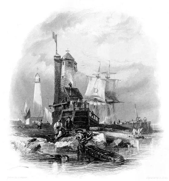 SUNDERLAND. THE LIGHT HOUSE ON THE SOUTH PIER.
SUNDERLAND,
THE LIGHTHOUSE ON THE SOUTH PIER.
Table of Contents
The view of the Lighthouse on Sunderland South Pier is taken from the south-east. The entrance to the harbour lies beyond the pier-head, to the right, on which a crane, and a capstan used in warping out ships, are perceived. The large D on the fore-topsail of the collier lying within the pier is a distinguishing mark adopted by the owner that his vessels may be more readily known. To the left is seen the higher lighthouse, of stone, which stands on the north pier, on the opposite side of the river.
The erection of a pier on each side of the entrance to Sunderland harbour has been rendered necessary in consequence of the constant tendency of the bar of sand at its mouth to accumulate. The piers, by contracting the channel of the river, have deepened the water, and increased the velocity of the current at ebb tide, which thus scours the entrance to the harbour, and prevents the accumulation of sand upon the bar.
In 1669, Charles II. granted letters patent to Edward Andrew, Esq., empowering him to build a pier, erect lighthouses, and cleanse the harbour at Sunderland, and also to raise funds for these purposes by a tonnage-duty on ships. At a subsequent period, commissioners were appointed for the same purposes by an act of parliament; and under their authority three hundred and thirty-three yards of the north pier were built, between 1716 and 1746. From a report of the commissioners made in 1765, it appears that £50,000 had been expended on the south pier up to that time, and it was estimated that to finish it would cost as much more. It is now extended to the length of six hundred and twenty-five yards. The north pier, which is entirely of stone, was commenced about 1785, but additions have been recently made to its eastern extremity.
The lighthouse on the north pier was erected in 1803. The light, which is stationary, is exhibited from sunset to sunrise, and is visible in clear weather at the distance of twelve miles. The light on the south pier is a tide light, and is only shown when there is sufficient depth of water on the bar for ships to enter. This light is of a red colour. By day a flag is hoisted during tide-time.
Since the year 1200—and probably from a much earlier period—the harbour at the mouth of the Wear appears to have been generally known as that of Sunderland, the present name of the port and of the parliamentary borough. "Various conjectures," says Mr. Surtees, "have been formed as to the derivation of this name; the simplest and most obvious seems to be, that it marked the original situation of the place on a point of land almost insulated by the Wear and by the sea, which has probably flowed much higher than at present up some of the deep gullies on the coast, particularly Hendon-Dene, which, it seems, contained, as late as 1350, water sufficient for vessels to ride at anchor in the bay."
In 1719 an express distinction was made by an act of parliament, which constituted Sunderland a separate parish from that of Bishop-Wearmouth, in which it had formerly been included. This act was passed on the petition of the inhabitants of Sunderland, who, between 1712 and 1719, had built a new church. The old church of Bishop-Wearmouth—which was pulled down and rebuilt in 1808—was probably founded shortly after the date of Athelstan's grant. The rectory of Sunderland is but slenderly endowed; that of Bishop-Wearmouth is one of the richest in the kingdom, and was at one period held by the Rev. Dr. Wellesley, a brother of the Duke of Wellington. Dr. Paley—whose "pigeon illustration," in his Moral Philosophy , of the basis of political authority, is said to have kept him out of a bishopric—was rewarded by Dr. Barrington, bishop of Durham, with the rectory of Bishop-Wearmouth, where he died in 1805.
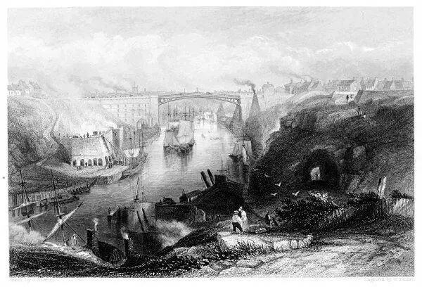 SUNDERLAND. (THE BRIDGE FROM THE WESTWARD.)
SUNDERLAND.
THE BRIDGE FROM THE WESTWARD.
Table of Contents
Under the general name of Sunderland, the three townships of Monk-Wearmouth, Bishop-Wearmouth, and Sunderland are usually comprised. Monk-Wearmouth is situated on the north side of the river Wear, at a short distance from its mouth. Sunderland and Bishop-Wearmouth, which form one continuous town, lie on the south side of the river; Sunderland, properly so called, extending from the line of junction of the two parishes, eastward to the sea; and Bishop-Wearmouth extending towards the west. Sunderland—which has given its name to the port and to the borough—is 269 miles distant from London; fourteen from Durham; and thirteen from Newcastle-on-Tyne.
The great boast of Sunderland is the beautiful iron bridge, of a single arch, which connects it with Monk-Wearmouth. This noble structure, which is at once highly ornamental and useful, was projected by Rowland Burdon, Esq., of Castle Eden, who in 1792, he being then M.P. for the county of Durham, obtained an act of parliament empowering him to raise money for its erection; the sums advanced to be secured on the tolls, with five per cent. interest, and all further accumulation to go in discharge of the capital. The abutments, from which the arch springs, are nearly solid masses of masonry, twenty-four feet thick, forty-two feet broad at bottom, and thirty-seven feet broad at top. That on the south side is founded on a solid rock, which rises above the level of the Wear; the foundation of that on the north side, owing to the unfavourable nature of the ground, was obliged to be laid ten feet below the level of the river. The arch, which is a segment of a large circle, is of 236 feet span, and its centre is ninety-four feet above the level of the river at low water. From the height of the arch and its comparative flatness—its versed sine, or perpendicular height from its centre to a line joining its extremities, being only thirty-four feet—ships of 300 tons burden can pass underneath not only directly below the centre, but also to the extent of fifty feet on each side. The navigation of the river thus remains unobstructed—for many vessels proceed to the staiths above the bridge for the purpose of taking in their coals—while the inhabitants on each side enjoy all the advantages of facilitated intercourse. The breadth of the bridge at the top is thirty-two feet including the footpaths on each side; and the carriage-way is formed of lime, marl, and gravel, above a flooring of timber, which is laid across the iron ribs of the arch. The iron ribs and blocks were cast and prepared at the foundry of Messrs. Walker, at Rotherham, near Sheffield. The whole weight of the iron is 260 tons; of which 46 tons are malleable, and 214 cast. The foundation-stone[4] was laid on the 24th September, 1793, and the bridge opened to the public on the 9th August, 1796, having been completed under the superintendence of Mr. Thomas Wilson, of Bishop-Wearmouth, in less than three years. The total expense was £26,000, of which sum £22,000 was subscribed by Mr. Burdon.[5]
Читать дальшеИнтервал:
Закладка:
Похожие книги на «The Ports, Harbours, Watering-places and Picturesque Scenery of Great Britain (Vol. 1&2)»
Представляем Вашему вниманию похожие книги на «The Ports, Harbours, Watering-places and Picturesque Scenery of Great Britain (Vol. 1&2)» списком для выбора. Мы отобрали схожую по названию и смыслу литературу в надежде предоставить читателям больше вариантов отыскать новые, интересные, ещё непрочитанные произведения.


Обсуждение, отзывы о книге «The Ports, Harbours, Watering-places and Picturesque Scenery of Great Britain (Vol. 1&2)» и просто собственные мнения читателей. Оставьте ваши комментарии, напишите, что Вы думаете о произведении, его смысле или главных героях. Укажите что конкретно понравилось, а что нет, и почему Вы так считаете.