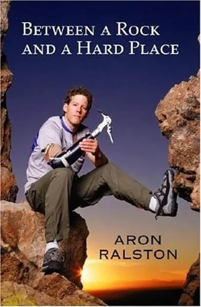
Aron Ralston - Between a Rock and a Hard Place
Здесь есть возможность читать онлайн «Aron Ralston - Between a Rock and a Hard Place» весь текст электронной книги совершенно бесплатно (целиком полную версию без сокращений). В некоторых случаях можно слушать аудио, скачать через торрент в формате fb2 и присутствует краткое содержание. Жанр: Триллер, на английском языке. Описание произведения, (предисловие) а так же отзывы посетителей доступны на портале библиотеки ЛибКат.
- Название:Between a Rock and a Hard Place
- Автор:
- Жанр:
- Год:неизвестен
- ISBN:нет данных
- Рейтинг книги:3 / 5. Голосов: 1
-
Избранное:Добавить в избранное
- Отзывы:
-
Ваша оценка:
Between a Rock and a Hard Place: краткое содержание, описание и аннотация
Предлагаем к чтению аннотацию, описание, краткое содержание или предисловие (зависит от того, что написал сам автор книги «Between a Rock and a Hard Place»). Если вы не нашли необходимую информацию о книге — напишите в комментариях, мы постараемся отыскать её.
And so began six days of hell for Aron Ralston.
Between a Rock and a Hard Place — читать онлайн бесплатно полную книгу (весь текст) целиком
Ниже представлен текст книги, разбитый по страницам. Система сохранения места последней прочитанной страницы, позволяет с удобством читать онлайн бесплатно книгу «Between a Rock and a Hard Place», без необходимости каждый раз заново искать на чём Вы остановились. Поставьте закладку, и сможете в любой момент перейти на страницу, на которой закончили чтение.
Интервал:
Закладка:
Afternoon sunlight turned the snow to mush on our descent back to my truck. The day’s warming temperatures had turned the parking lot and the road to mud. My truck wheels slopped around in the tracks I’d made on our way in, threatening to pitch us off the narrow road and adding more excitement to the day. Almost past the last pit of slushy snow, a steering mistake bounced us out of the ruts, and I barely brought the vehicle to a stop before sliding sideways into the sodden forest. Brad speculated that my four-wheel drive wasn’t working correctly; otherwise, I would have been able to drive out of the predicament. As it was, soft mud and snow on top of thick ice left us stranded, tires spinning, for an hour and a half until-thank God for cell phones-Brad’s girlfriend, Leah, arrived with a tow rope. We put my chains on Brad’s tires, hooked up the tow rope, and, gunning our engines simultaneously, freed my truck.
With a plan for me to call Brad’s cell phone on Saturday to get final directions to the Goblin Valley party, Brad and Leah left for Silverton over McClure Pass, and I drove down to Glenwood Springs, westward-bound. I drove three hours down the highway, reading in my canyoneering guidebook about the slot canyons near Moab and Green River. I pondered the possible itineraries and figured that I’d go mountain biking in the morning on the Slick Rock Trail down by Moab, then go for a canyon hike on Saturday that would put me in range of the desert party at Goblin Valley. Five miles along I-70 past Thompson Springs, Utah, I pulled off the interstate at a large rest area and backed my truck up into the darkest parking spot between two sixty-foot-high light poles illuminating the half-dozen landscaped mesquite trees near the picnic shelters. I laid out my sleeping bag in the bed of my pickup and crawled in, with just enough sense left in me to take out my contacts before falling into a well-earned sleep.
Friday morning, I drove the thirty miles south into Moab for an all-day mountain-biking excursion on the Slick Rock Trail. Slick Rock is one of Utah’s most popular biking trails because of its twelve miles of technical sandstone challenges with only a few sand traps; its numerous viewpoints with expansive vistas of the Colorado River canyons; and its proximity to the center of Moab. I laughed at the sight of my truck in the bike trailhead parking lot, with skis on the roof rack and not a snowflake to be seen for fifty miles.
Heading out on my own, I soon caught up to a group of four proficient bikers and tailed them through the warm-up problems. Shortly thereafter, they ascended a technical challenge that was beyond my ability. Running headlong into a ten-foot-high slab of seemingly vertical rock, I toppled off the side of my bike, clipping out of my pedals in time to avoid a humiliating spill. It was my first time riding sandstone, and I found out how much I had to learn as the first dozen problems harder than a six out of ten on the local scale of difficulty thwarted me. Thankfully, each time, I safely escaped my bucking bike.
I focused on developing my skills, tackling some problems three and four times each to get them right. Mimicking some of the better bikers’ techniques on a steep fifty-foot-high sandstone dome, I stood up on my pedals and thrust my weight all the way over my handlebars, compressing the shock on my front fork. I couldn’t believe my tires didn’t skid out and force yet another abortive dismount. Cranking hard in my lowest gear, I hammered my way up the sandstone, knowing that a slip would plant my crotch squarely on the bent neck of my handlebars. Gasping for oxygen, I felt my momentum dissipate as my legs screamed in fury, but I pumped out the last few revolutions and collapsed in my seat at the top of the dome.
By mile eight, I was able to cleanly ride the sixes, sevens, and even an eight without coming out of my toe clips. Predictably, right as I was getting confident with my riding, I got a full-on ego check in the return portion of the loop when I descended into a sand trap with my weight too far forward. I blinked, and the next time I opened my eyes, I was flat on my belly, nose deep in the sand. My bike was piled on top of my legs, back, and neck, with the handlebar pressing my head down. I squirmed and wriggled, but my legs were twisted up behind my butt, with my right foot still attached to the pedal of the upturned bike. I’d been pinned by a two-wheeled wrestling champion in a startling takedown. The airburst of my laugh blew sand up around my face, pasting grit onto my sweaty cheeks. I couldn’t decide if I was more relieved that no one had seen my over-the-handlebars wreck, or disappointed that there was no one to laugh with me at my utter discombobulation. Back at the beginning of the circuit, I re-attempted the problem that had first ejected me and cleaned it in front of a group of other bikers who had all dismounted to walk up the slab.
Excited and exhausted by the day, I sat at my truck and consulted my canyon guidebook about Negro Bill Canyon. A two-mile hike would take me into a natural bridge with the sixth longest span in the United States. I had enough time to drive around to the trailhead and jog in to the bridge before twilight, when the light would be best for photography.
In past excursions to Utah, I mountain-biked hundred-mile-long routes and traversed forty-mile-long canyons in a single day on foot. While I found the obvious physical challenge of these excursions an attraction in itself, I always carried my camera equipment to capture images of the Martian landscapes, surreal shapes, alluring colors, and hidden treasures of petroglyphs and kivas from cultures long disappeared. The hike in Negro Bill Canyon produced a half-dozen image sets from the streamside hiking route, as well as the natural bridge. My favorite was a picture of the azure skies and auburn desert walls reflected in a mirror-still pool surrounded by green reeds and grasses. While I was happy that I’d made the hike, my photographic appetite was only whetted. I wanted to get out to a slot canyon and see some petroglyphs.
I’d already identified the Robbers Roost area east of Hanksville for my Saturday adventure, but I hadn’t picked out a specific canyon. I wanted to position myself for the Saturday-night rendezvous, and the Roost was ideal-two hours from Moab and two hours from Goblin Valley. Since I wouldn’t be back in the vicinity of a grocery or convenience store for two days, I needed to stock up on water and food before I left civilization for the weekend. So I wouldn’t have to carry the entire guidebook with me, I photocopied the pages of three canyons in the Robbers Roost that offered the best opportunities for narrow slots and petroglyphs. Topping off my gas tank, I was ready for an extended desert foray. I left Moab in the late evening, driving north to the interstate. I set the cruise control and read through the canyon-guide photocopies. Piecing together two descriptions of adjoining canyons, I created a unique loop that would take me on a fifteen-mile bike ride from my truck at the Canyonlands National Park trailhead to the head of Blue John Canyon, through two narrow and deep slots, over a twenty-meter rappel, and out to the confluence with Horseshoe Canyon, past the petroglyph alcoves of the Great Gallery, finally returning to my vehicle. A thirty-mile day. I figured if I started by nine A.M., I would be out by five P.M.
At mile 162 on I-70, I exited for Green River, recognizing the sign warning travelers that the next available gas and food services were 110 miles to the west. I stopped at a convenience store in Green River and considered whether to call Brad and Leah for a final confirmation on the Goblin Valley party. Because of the late hour, I deferred the call, thinking I would get in touch the next afternoon from Hanksville. Brad would be getting up early in the morning to ski, and I didn’t want to wake them. I bought two bottles of Gatorade in the store and then made a lap up and down Green River’s main street until I found the Bureau of Land Management access road heading south out of town.
Читать дальшеИнтервал:
Закладка:
Похожие книги на «Between a Rock and a Hard Place»
Представляем Вашему вниманию похожие книги на «Between a Rock and a Hard Place» списком для выбора. Мы отобрали схожую по названию и смыслу литературу в надежде предоставить читателям больше вариантов отыскать новые, интересные, ещё непрочитанные произведения.


Обсуждение, отзывы о книге «Between a Rock and a Hard Place» и просто собственные мнения читателей. Оставьте ваши комментарии, напишите, что Вы думаете о произведении, его смысле или главных героях. Укажите что конкретно понравилось, а что нет, и почему Вы так считаете.